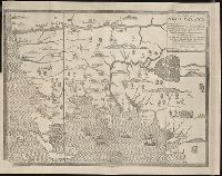
The present state of New-England ; being a narrative of the troubles with the Indians in New
Image Count:
2
Description:
Imperfect: map wanting and supplied in facsimile; only a remnant of original map remains. This copy has what is considered the correct map for this edition, the mound immediately beneath the title being designated as "The Wine Hills", the Boston editi...
Subject (Geographic):
New England --History --Colonial period, ca. 1600-1775
Subject (Topic):
Indians of North America --New England, King Philips War, 1675-1676., and Pequot War, 1636-1638.
[Atlas nouveau contenant toutes les parties du monde ou sont exactement marques les empires
Image Count:
1
Resource Type:
Maps, Atlases & Globes
Abstract:
Factitious collection of about 549 maps taken from the atlases of the 17th and the beginning of the 18th century, put together with the title "Atlas" and bound in 6 volumes. These volumes originally bore the imprint: Amstelaedamii apvd Reiniervm & Jos...
Description:
Verso blank.
Subject (Geographic):
British Isles --Maps --Early works to 1800
Subject (Name):
Leth, Hendrik de, 1703-1766, Reiner et Josua Ottens (Firm), Schenck, Peter, 1661-1715, Schenck, Peter, ca. 1698-1752, Valck, G. (Gerard), 1651 or 2-1726, and Wit, Frederik de
Subject (Topic):
Atlases --Early works to 1800
Collection Created:
[A Amsterdam, chez J. Covens & C. Mortier, ca. 1730-ca. 1800]