Skip to search
Skip to main content
Skip to first result
Search
You Searched For
Date
1700 - 1799
Extent of Digitization
Partially digitized
Format
cartographic
Date Created
1700 to 1799
New Search
Search Results
Creator:
Published / Created:
1756
Call Number:
Efd 726S
Collection Title:
A new voyage to Guinea: describing the customs, manners, soil, climate, habits, buildings
Image Count:
1
Resource Type:
Maps, Atlases & Globes
Publisher:
J. Nourse
Collection Created:
London, J. Nourse, 1744
Found in:
Beinecke Rare Book and Manuscript Library > A General Map of Senegal, Corrected and Improved with several particulars by Mr. Adanson, correspondent of the Royal Academy of Sciences. Drawn and executed by Philip Buache, 1756
Published / Created:
1704
Call Number:
Cxb e678ge
Collection Title:
The history of the bucaniers of America : from the first original down to this time; written in
Image Count:
1
Resource Type:
Maps, Atlases & Globes
Alternative Title:
[Piratas de América. English]
Publisher:
Printed for T. Newborough [etc.]
Collection Created:
London : Printed for T. Newborough [etc.],
Found in:
Beinecke Rare Book and Manuscript Library > A Map of the Countrey and Citty of Panama. Part 3: Chap: 5.
Published / Created:
1719
Call Number:
Defoe 50 719db 1
Collection Title:
The life and strange surprizing adventures of Robinson Crusoe, of York, mariner : who lived eight
Image Count:
1
Resource Type:
Maps, Atlases & Globes
Description:
Map facing p. [1]
Subject (Topic):
Voyages and travels, Voyages around the world, and World maps --Early works to 1800
Collection Created:
London : Printed for W. Taylor, 1719
Found in:
Beinecke Rare Book and Manuscript Library > A Map of the world, on wch is delineated the voyages of Robinson Cruso
Published / Created:
1704
Call Number:
1973 Folio 70
Collection Title:
A new sett of maps, both of antient and present geography ... Together with a Geographical treatise
Image Count:
1
Resource Type:
Maps, Atlases & Globes
Publisher:
Printed at the Theater
Collection Created:
Oxford, Printed at the Theater, 1704
Found in:
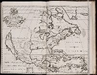
Beinecke Rare Book and Manuscript Library > A New Map of North America Shewing its Principal Divisions, Chief Cities, Townes, Rivers, Mountains &c. Dedicated to His Highness William Duke of Glocester
Published / Created:
1704
Call Number:
1973 Folio 70
Collection Title:
A new sett of maps, both of antient and present geography ... Together with a Geographical treatise
Image Count:
1
Resource Type:
Maps, Atlases & Globes
Publisher:
Printed at the Theater
Collection Created:
Oxford, Printed at the Theater, 1704
Found in:
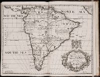
Beinecke Rare Book and Manuscript Library > A New Map of South America; Shewing its General Divisions, Chief Cities, Towns; Rivers, Mountains &c. Dedicated to His Highness William Duke of Gloucester
Published / Created:
1704
Call Number:
1973 Folio 70
Collection Title:
A new sett of maps, both of antient and present geography ... Together with a Geographical treatise
Image Count:
1
Resource Type:
Maps, Atlases & Globes
Publisher:
Printed at the Theater
Collection Created:
Oxford, Printed at the Theater, 1704
Found in:
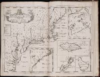
Beinecke Rare Book and Manuscript Library > A New Map of the Most Considerable Plantations of the English in America. Dedicated to His Highness William Duke of Glocester
Published / Created:
1739
Call Number:
WeInd Ehc 739
Collection Title:
A description of the Windward Passage, and Gulf of Florida, with the course of the British trading
Image Count:
1
Resource Type:
Maps, Atlases & Globes
Description:
Facing p. 20
Subject (Geographic):
Latin America --Commerce and West Indies --Description and travel
Subject (Topic):
Windward Passage
Collection Created:
London : Printed and sold by J. Applebee [etc.], 1739
Found in:
Beinecke Rare Book and Manuscript Library > A chart of the Bahamas Islands with a description of the Gulf of Florida and Windward passage &c. referr'd from the figures here set down, to the general index annexed ... by J.C
Creator:
Published / Created:
1776
Call Number:
1977 +300
Collection Title:
A voyage towards the South pole, and round the world. Performed in His Majesty’s ships the
Image Count:
1
Resource Type:
Maps, Atlases & Globes
Subject (Geographic):
Antarctica --Maps --Early works to 1800 and Southern Hemisphere --Maps
Subject (Name):
Furneaux, Tobias, 1735-1781 and Hodges, William, 1744-1797
Subject (Topic):
Oceania --Discovery and exploration and Voyages around the world
Collection Created:
London, Printed for W. Strahan and T. Cadell, 1777
Found in:
Beinecke Rare Book and Manuscript Library > A chart of the southern hemisphere; shewing the tracks of some of the most distinguished navigators
Creator:
Published / Created:
[1732]
Call Number:
E1015 M66 1732
Collection Title:
Atlas minor: or a set of sixty-two new and correct maps, of all parts of the world. All composed
Image Count:
1
Description:
Autograph of Gravely. Autograph of Baldock. Autograph of Aston. Autograph of W. Alington. and Teaching resource: Professor John Mack Faragher, History 141: The American West.
Subject (Geographic):
America--Maps--Early works to 1800 and Fundy, Bay of--Maps
Subject (Topic):
Atlases--Early works to 1800
Collection Created:
London :
Found in:
Beinecke Rare Book and Manuscript Library > A description of the Bay of Fundy showing ye coast, islands, harbours, creeks, coves, rocks, sholes, soundings & anchorings &c... Observed by Nat. Blackmore in ye yeare 1711 and 1712 ...
Creator:
Published / Created:
1773
Call Number:
1979 Folio 59
Image Count:
2
Resource Type:
Maps, Atlases & Globes
Publisher:
Printed for Robert Sayer, map and printseller, at no. 53, in Fleet-Street,
Subject (Geographic):
Scotland --Maps --Early works to 1800
Subject (Name):
Sayer, Robert, 1725-1794
Found in:
Beinecke Rare Book and Manuscript Library > A general atlas, describing the whole universe. Being a compleat and new collection of the most approved maps extant; corrected with the utmost care, and augmented from the latest discoveries: the whole being an improvement of the maps of d'Anville and Robert ... By Thomas Kitchen, senior, and others ...
Branch:v1.61.6 ,Deployed:2024-06-12T09:55:36-04:00