
You Searched For
1 - 7 of 7
Search Results
- Creator:
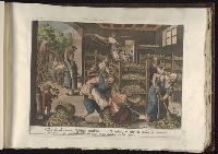
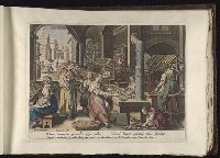
- Mallery, Karel van, 1571-ca. 1635
- Call Number:
- Folio 101
- Collection Title:
- Vermis sericus / Ioannes Stradanus inuentor DD
- Image Count:
- 1
- Resource Type:
- Prints & Photographs
- Subject (Topic):
- Sericulture--Pictorial works--Early works to 1800, Silkworms--Pictorial works--Early works to 1800, and Women--Employment--Pictorial works--Early works to 1800
- Collection Created:
- [Antwerp :
- Found in:
- Beinecke Rare Book and Manuscript Library > 6. Hinc vermium permulta saepe millia/ Simul legunt, parantq. telas feminae
3.
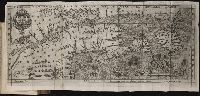
- Creator:
- Lescarbot, Marc
- Published / Created:
- [1609]
- Call Number:
- Pequot L56
- Collection Title:
- Histoire de la Nouvelle France : contenant les navigations, decouvertes, & habitations faites par
- Image Count:
- 1
- Alternative Title:
- Figure de la terre neuve, grande ri
- Description:
- Bound in after p. 236., Depicts coat of arms of Henry IV of France., In pencil on verso: 236., Map has one small hole along fold of second panel at the top., Map has several small brown marks, most notably on the verso., and Scale [ca. 1:9,428,600].
- Subject (Geographic):
- Acadia --Early works to 1800, America --Discovery and exploration --French --Early works to 1800, New France --Discovery and exploration --Early works to 1800, and New France --Maps --Early works to 1800
- Subject (Name):
- Millot, Jean, b. 1582, printer, Swelinck, Jan, engraver , and Villegaignon, Nicolas Durand de, 1510-1571?
- Subject (Topic):
- Indians of North America --Early works to 1800 and Indians of North America --Nova Scotia --Early works to 1800
- Collection Created:
- A Paris, Chez Iean Milot,
- Found in:
- Beinecke Rare Book and Manuscript Library > Figure de la terre neuue, grande riuiere de Canada, et cotes de l’ocean en la Nouuelle France / Ian Swelinc fecit ; I. Millot excudit ; Marcus Lescarbot nunc primum delineauit, publicauit, donauit. Auec priuilege du Roy
4.
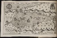
- Creator:
- Lescarbot, Marc
- Published / Created:
- 1609
- Call Number:
- Pequot L56
- Collection Title:
- Histoire de la Nouvelle-France : contenant les navigations, decouvertes, & habitations faites par
- Image Count:
- 1
- Description:
- Bound in after p. 496., In pencil in upper left corner: 497., Map has three or four small brown marks on verso, the largest of which is on the right margin., and Scale not given.
- Subject (Geographic):
- America --Discovery and exploration --French --Early works to 1800, New France --Discovery and exploration --Early works to 1800, and New France --Maps --Early works to 1800
- Subject (Name):
- Millot, Jean, b. 1582, printer, Swelinck, Jan, engraver, and Villegaignon, Nicolas Durand de, 1510-1571?
- Collection Created:
- A Paris, Chez Iean Milot,
- Found in:
- Beinecke Rare Book and Manuscript Library > Figure du Port Royal en la Nouuelle France / par Marc Lescarbot ; Jan Swelinck sculp. ; I. Millot excudit

- Published / Created:
- Undated
- Call Number:
- Taylor 232
- Collection Title:
- Mecometrie de leymant, cest a dire La maniere de mesvrer les longitudes par le moyen de l’eymant
- Image Count:
- 1
- Description:
- Bound in preceding t.p. for pt. [2] (Premier livre de la Mecometrie arithmetique de l’eymant)., Imperfect: map rubbed, with some loss of map and text., Map has small tear on left edge at gutter., and Scale [ca. 1:100,000,000].
- Subject (Topic):
- Longitude --Early works to 1800 and World maps --Early works to 1800
- Collection Created:
- [France] Imprime a Venes ches l’autheur, 1603-04
- Found in:
- Beinecke Rare Book and Manuscript Library > Orbis terrae compendiosa descriptio ex peritis simorum totius orbis gaeographorum tabulis et novissimis observationibus desumpta

- Published / Created:
- 1612
- Call Number:
- Pequot G325
- Collection Title:
- Descriptio ac delineatio geographica detectionis freti, sive, transitus ad occasum supra terras
- Image Count:
- 1
- Abstract:
- Map depicts the Coat of Arms of the United Kingdom (era of the Union of the Crowns), reigning between the years 1603-1707.
- Alternative Title:
- Tabula nautica, qua repraesentantur orae maritimae, meatus, ac freta, noviter a H. Hudsono Anglo ad Caurum supra Novam Franciam
- Description:
- Bound in after p. [2]., In pencil on recto: 170., Map cut and folded irregularly., Map has multiple small stains on both the recto and verso., and Scale [ca. 1:9,000,000].
- Subject (Geographic):
- North Atlantic Ocean --Maps --Early works to 1800
- Subject (Name):
- Hudson, Henry, d. 1611
- Collection Created:
- Amsterodami Ex officina Hesse lij Gerardi. Anno
- Found in:
- Beinecke Rare Book and Manuscript Library > Tabula nautica ...

- Creator:
- Cóvens et Mortier
- Published / Created:
- ca. 1730-ca. 1800]
- Call Number:
- 1973 Folio 71
- Image Count:
- 1
- Resource Type:
- Maps, Atlases & Globes
- Description:
- All volumes bound to match 1973 Folio 72. Factitious collection of about 549 maps taken from the atlases of the 17th and the beginning of the 18th cent., put together with the title "Atlas" and bound in 6 volumes. These volumes originally bore the imprint: Amstelaedamii apvd Reiniervm & Josvam Ottens. Over these words on the title-pages of v. 1-2, 4-6 is the name of Henrik de Leth who painted them. Volume 3 has only the erased imprint of Ottens., For fuller description see Phillips 3448 and C. Koeman's Atlantes Neerlandici, bibliography of terrestrial, maritime and celestial atlases and pilot books, published in the Netherlands up to 1800, Amsterdam c1967-71, v. 2, p. 63-83., and Maps by P. Schenck and son, G. Valck, F. de Wit, N. Visscher and others.
- Publisher:
- chez J. Covens & C. Mortier,
- Subject (Geographic):
- Denmark --Maps --Early works to 1800
- Subject (Name):
- Reiner et Josua Ottens (Firm), Schenk, Peter, 1660-1718 or 1719., and Valck, G. (Gerard), 1651 or 1652-1726.
- Subject (Topic):
- Atlases--Early works to 1800.
- Found in:
- Beinecke Rare Book and Manuscript Library > [Atlas nouveau contenant toutes les parties du monde ou sont exactement marqués les empires, monarchies, royaumes, états, republiques &c. Le tout recueilli par les meilleurs geógraphes.]