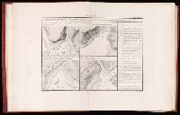
1. Environs de Brest.--2. Les côtes occidentales, depuis la pointe de Penmarc'h jusqu'à l'île d'Yeu.--3. Les côtes occidentales, depuis l'île d'Yeu jusqu'à la côte d'Espagne.--4. Les côtes septentrionales depuis l'île Bréhat jusqu'à Barfleur.--5. Les côtes septentrionales depuis Barfleur jusqu'à Dunkerque.--6. Les côtes septentrionales depuis les roches de Porsal jusqu'àu phare des Heaux de Bréhat. and Imperfect: v.3-6 wanting; t.-p. of v. 2 wanting.
Publisher:
Au Dépot-général de la Marine,
Subject (Name):
France. Service hydrographique. and Karpinski, Louis Charles,--1878-1956--Stamp.
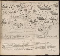
Les voyages dv sievr de Champlain Xaintongeois, capitaine ordinaire pour le Roy, en la marine
Image Count:
1
Description:
Bound in after p. 132.
Subject (Geographic):
Chatham (Mass.), Massachusetts --Pictorial works, and New France --Discovery and exploration
Subject (Name):
Pelletier, David
Subject (Topic):
Indians of North America --Canada
Collection Created:
A Paris : Chez Iean Berjon, rue S. Iean de Beauuais, au Cheual volant, & en sa boutique au Palais, a la gallerie des prisonniers, MDCXIII [1613]. Avec privilege dv Roy
Descriptio ac delineatio geographica detectionis freti, sive, transitus ad occasum supra terras
Image Count:
1
Abstract:
Map depicts the Coat of Arms of the United Kingdom (era of the Union of the Crowns), reigning between the years 1603-1707.
Alternative Title:
Tabula nautica, qua repraesentantur orae maritimae, meatus, ac freta, noviter a H. Hudsono Anglo ad Caurum supra Novam Franciam
Description:
Bound in after p. [2]., In pencil on recto: 170., Map cut and folded irregularly., Map has multiple small stains on both the recto and verso., and Scale [ca. 1:9,000,000].
All volumes bound to match 1973 Folio 72. Factitious collection of about 549 maps taken from the atlases of the 17th and the beginning of the 18th cent., put together with the title "Atlas" and bound in 6 volumes. These volumes originally bore the imprint: Amstelaedamii apvd Reiniervm & Josvam Ottens. Over these words on the title-pages of v. 1-2, 4-6 is the name of Henrik de Leth who painted them. Volume 3 has only the erased imprint of Ottens., For fuller description see Phillips 3448 and C. Koeman's Atlantes Neerlandici, bibliography of terrestrial, maritime and celestial atlases and pilot books, published in the Netherlands up to 1800, Amsterdam c1967-71, v. 2, p. 63-83., and Maps by P. Schenck and son, G. Valck, F. de Wit, N. Visscher and others.
Publisher:
chez J. Covens & C. Mortier,
Subject (Geographic):
Denmark --Maps --Early works to 1800
Subject (Name):
Reiner et Josua Ottens (Firm), Schenk, Peter, 1660-1718 or 1719., and Valck, G. (Gerard), 1651 or 1652-1726.
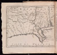
Histoire de la Louisiane : contenant la decouverte de ce vaste pays ; sa description geographique
Image Count:
1
Subject (Geographic):
Louisiana --Description and travel, Louisiana --History --To 1803, Louisiana --Maps --Early works to 1800, Mexico, Gulf of --Discovery and exploration --French, and Mexico, Gulf of --Maps --Early works to 1800
Subject (Topic):
Indians of North America --Mississippi River Valley and Natural history --Louisiana