[Atlas factice of 96 maps by Blaeu, Visscher, Jansson, Hondius and others]
Image Count:
2
Description:
Imperfect: lower left corner [imprint] cut-out and replaced with ms. ill.; edges reinforced with ms waste. Sheet measures 38.5 x 48.9 cm. No. 67 of 92 maps bound together. and Numbered 72 on verso.
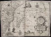
Nauigatio ac itinerarium Iohannis Hugonis Linscotani in Orientalem siue Lusitanorum Indiam
Image Count:
1
Description:
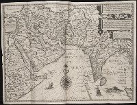
[Scale ca. 1:19,000,000]., Bound in following page 36., In pencil on bottom left panel of right verso: 36 sec(?) [upside down when unfolded; upright orientation when folded]., In pencil on middle right panel of right verso: 34-2., Map has several small tears now repaired on verso., and Map has two burn holes just to the right of the island of Cuba.
Subject (Geographic):
Brazil --Maps --Early works to 1800, Chile --Maps --Early works to 1800, Peru --Maps, and South America --Maps --Early works to 1800
Subject (Name):
Claesz, Cornelis, ca. 1546-1609, Elzevier, Gillis, bookseller, and Hendricksz, Aelbrecht, fl. 1573-1605, printer
Subject (Topic):
Voyages and travels --Early works to 1800
Collection Created:
Hagae-Comitis : Ex officina Alberti Henrici, impensis authoris & Cornelii Nicolai, prostantque apud Aegidium Elseuirum, anno
Nauigatio ac itinerarium Iohannis Hugonis Linscotani in Orientalem siue Lusitanorum Indiam
Image Count:
1
Description:
[Scale ca. 1:13,500,000]., Bound in following page 8., In pencil on bottom right panel of left verso: 8., In pencil on middle left panel of left verso: x., In pencil on middle right panel of left verso: 7-1., and Map has several tears along folds now repaired on verso.
Subject (Geographic):
Africa --Maps --Early works to 1800, Africa, East --Maps, and Madagascar --Maps --Early works to 1800
Subject (Name):
Claesz, Cornelis, ca. 1546-1609, publisher, Elzevier, Gillis, bookseller, and Hendricksz, Aelbrecht, fl. 1573-1605, printer
Subject (Topic):
Voyages and travels --Early works to 1800
Collection Created:
Hagae-Comitis : Ex officina Alberti Henrici, impensis authoris & Cornelii Nicolai, prostantque apud Aegidium Elseuirum, anno 1599
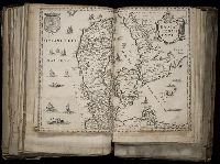
Nauigatio ac itinerarium Iohannis Hugonis Linscotani in Orientalem siue Lusitanorum Indiam
Image Count:
1
Description:
[Scale ca. 1:13,500,000]., Bound in following page 14., In pencil on middle left panel of left verso: 13-1., In pencil on middle left panel of right verso: 13., and Map has small tear along top center fold.
Subject (Geographic):
Afghanistan --Maps, Egypt --Maps --Early works to 1800, India --Maps, Iran --Maps --Early works to 1800, Iraq --Maps, Pakistan --Maps, and Saudi Arabia --Maps
Subject (Name):
Claesz, Cornelis, ca. 1546-1609, publisher, Elzevier, Gillis, bookseller, and Hendricksz, Aelbrecht, fl. 1573-1605, printer
Subject (Topic):
Voyages and travels --Early works to 1800
Collection Created:
Hagae-Comitis : Ex officina Alberti Henrici, impensis authoris & Cornelii Nicolai, prostantque apud Aegidium Elseuirum, anno 1599
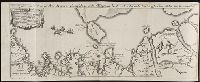
Barentsz, Willem, ca. 1550-1597. Deliniatio cartae trium navagationum Claesz, Cornelis, ca. 1546-1609 Duetecum, Baptista
Published / Created:
1598
Call Number:
Pequot +L65
Collection Title:
Nauigatio ac itinerarium Iohannis Hugonis Linscotani in Orientalem siue Lusitanorum Indiam
Image Count:
1
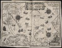
Description:
Bound in following page 16., In pencil on bottom left panel of right verso: 91 1 [upside down when unfolded; upright orientation when folded]., In pencil on middle right panel of left verso: 17-2., In pencil on top right panel of right verso: +., Map has several tears now repaired on verso., and Scale not given.
Subject (Geographic):
Arctic Ocean --Maps, Finland --Maps --Early works to 1800, Greenland --Maps --Early works to 1800, Iceland --Maps --Early works to 1800, Norway --Maps --Early works to 1800, and Sweden --Maps
Subject (Name):
Elzevier, Gillis, bookseller, Hendricksz, Aelbrecht, fl. 1573-1605, printer, and Langren, Arnold Florent van, 1580-1644
Subject (Topic):
Voyages and travels --Early works to 1800
Collection Created:
Hagae-Comitis : Ex officina Alberti Henrici, impensis authoris & Cornelii Nicolai, prostantque apud Aegidium Elseuirum, anno 1599
Engraved t.-p., within ornamental border., Errata: p. [1] at end., Imperfect: 2 p.l. and first map, "Orbis terrarum," wanting; autograph of Amadeus Canalius; unidentified bookplate: Sc. 8. D N. 28., and Signatures: [*]⁴ A-Aa⁴.
Publisher:
Tijpis Iohannis Bogardi,
Subject (Geographic):
America--Discovery and exploration., America--Early accounts to 1600., and America--Maps--Early works to 1800.
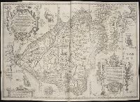
Nauigatio ac itinerarium Iohannis Hugonis Linscotani in Orientalem siue Lusitanorum Indiam
Image Count:
1
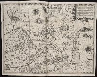
Description:
[Scale ca. 1:13,500,000]., Bound in following page 22., In pencil on middle left panel of left verso: 23., In pencil on middle right panel of left verso: 22-1., and Map has several areas of staining most noticeably along the top verso.
Subject (Geographic):
Borneo --Maps, China --Maps --Early works to 1800, Indonesia --Maps, Japan --Maps --Early works to 1800, Java (Indonesia) --Maps --Early works to 1800, and Philippines --Maps
Subject (Name):
Claesz, Cornelis, ca. 1546-1609, publisher, Elzevier, Gillis, bookseller, and Hendricksz, Aelbrecht, fl. 1573-1605, printer
Subject (Topic):
Voyages and travels --Early works to 1800
Collection Created:
Hagae-Comitis : Ex officina Alberti Henrici, impensis authoris & Cornelii Nicolai, prostantque apud Aegidium Elseuirum, anno 1599