Search
You Searched For
Search Results
- Call Number:
- 1977 +250
- Collection Title:
- Geografia; cioe, Descrittione vniversale della terra. Partita in due volumi, nel primo de’ quali si
- Image Count:
- 1
- Resource Type:
- Maps, Atlases & Globes
- Found in:
- Beinecke Rare Book and Manuscript Library > Descrittione dell'America, odell'India Occidentale. America
- Call Number:
- 1977 +250
- Collection Title:
- Geografia; cioe, Descrittione vniversale della terra. Partita in due volumi, nel primo de’ quali si
- Image Count:
- 1
- Resource Type:
- Maps, Atlases & Globes
- Found in:
- Beinecke Rare Book and Manuscript Library > Descrittione di tvtto'l mondo, secondo la prattica de Marinari. Vniversi orbis descriptio ad vsvm navigantivm
- Call Number:
- 1977 +392
- Collection Title:
- A survey of the cities of London and Westminster : containing the original, antiquity, increase
- Image Count:
- 1
- Resource Type:
- Maps, Atlases & Globes
- Found in:
- Beinecke Rare Book and Manuscript Library > Portsoken ward being part of the parish of St. Buttolphs Aldgate, taken from the last survey, with corrections and additions
- Call Number:
- 1977 +392
- Collection Title:
- A survey of the cities of London and Westminster : containing the original, antiquity, increase
- Image Count:
- 1
- Resource Type:
- Maps, Atlases & Globes
- Found in:
- Beinecke Rare Book and Manuscript Library > The Custom House
- Call Number:
- 1977 +392
- Collection Title:
- A survey of the cities of London and Westminster : containing the original, antiquity, increase
- Image Count:
- 1
- Resource Type:
- Maps, Atlases & Globes
- Found in:
- Beinecke Rare Book and Manuscript Library > Aldgate Ward with its division into parishes. Taken from the last survey, with corrections & additions
- Call Number:
- 1977 +392
- Collection Title:
- A survey of the cities of London and Westminster : containing the original, antiquity, increase
- Image Count:
- 1
- Resource Type:
- Maps, Atlases & Globes
- Found in:
- Beinecke Rare Book and Manuscript Library > Part of Aldgate Ward
- Call Number:
- 1977 +392
- Collection Title:
- A survey of the cities of London and Westminster : containing the original, antiquity, increase
- Image Count:
- 1
- Resource Type:
- Maps, Atlases & Globes
- Found in:
- Beinecke Rare Book and Manuscript Library > Bishop Gate Street Ward taken from the last survey and corrected
- Call Number:
- 1977 +392
- Collection Title:
- A survey of the cities of London and Westminster : containing the original, antiquity, increase
- Image Count:
- 1
- Resource Type:
- Maps, Atlases & Globes
- Found in:
- Beinecke Rare Book and Manuscript Library > Cornhill Ward with its division into parishes, taken from the last survey &c
- Call Number:
- 1977 +392
- Collection Title:
- A survey of the cities of London and Westminster : containing the original, antiquity, increase
- Image Count:
- 1
- Found in:
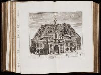
- Beinecke Rare Book and Manuscript Library > The Royal Exchange of London
- Call Number:
- 1977 +392
- Collection Title:
- A survey of the cities of London and Westminster : containing the original, antiquity, increase
- Image Count:
- 1
- Resource Type:
- Maps, Atlases & Globes
- Found in:
- Beinecke Rare Book and Manuscript Library > Candlewick Ward with its division into parishes. Corrected from the last survey
- Call Number:
- 1977 +392
- Collection Title:
- A survey of the cities of London and Westminster : containing the original, antiquity, increase
- Image Count:
- 1
- Resource Type:
- Maps, Atlases & Globes
- Found in:
- Beinecke Rare Book and Manuscript Library > Walbrook Ward and Dow Gate Ward with its division into parishes taken from the last surveys
- Call Number:
- 1977 +392
- Collection Title:
- A survey of the cities of London and Westminster : containing the original, antiquity, increase
- Image Count:
- 1
- Resource Type:
- Maps, Atlases & Globes
- Found in:
- Beinecke Rare Book and Manuscript Library > Queen Hith Ward and Vintry Ward with their division into parishes taken from the last surveys
- Call Number:
- 1977 +392
- Collection Title:
- A survey of the cities of London and Westminster : containing the original, antiquity, increase
- Image Count:
- 1
- Resource Type:
- Maps, Atlases & Globes
- Found in:
- Beinecke Rare Book and Manuscript Library > Bread Street Ward and Cordwainer Ward with it's division into parishes taken from the last survey
- Call Number:
- 1977 +392
- Collection Title:
- A survey of the cities of London and Westminster : containing the original, antiquity, increase
- Image Count:
- 1
- Resource Type:
- Maps, Atlases & Globes
- Found in:
- Beinecke Rare Book and Manuscript Library > Cheape Ward with its division into parishes, taken from the last survey, with corrections and additions
- Call Number:
- 1977 +392
- Collection Title:
- A survey of the cities of London and Westminster : containing the original, antiquity, increase
- Image Count:
- 1
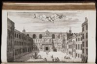
- Found in:
- Beinecke Rare Book and Manuscript Library > The Prospect of Guild Hall
- Call Number:
- 1977 +392
- Collection Title:
- A survey of the cities of London and Westminster : containing the original, antiquity, increase
- Image Count:
- 1
- Resource Type:
- Maps, Atlases & Globes
- Found in:
- Beinecke Rare Book and Manuscript Library > Coleman Street Ward and Bashishaw Ward taken from the last survey, with corrections and additions
- Call Number:
- 1977 +392
- Collection Title:
- A survey of the cities of London and Westminster : containing the original, antiquity, increase
- Image Count:
- 1
- Resource Type:
- Maps, Atlases & Globes
- Found in:
- Beinecke Rare Book and Manuscript Library > The Wards of Farington within and Baynards Castle with its divisions into parishes taken from the last survey with corrections
- Call Number:
- 1977 +392
- Collection Title:
- A survey of the cities of London and Westminster : containing the original, antiquity, increase
- Image Count:
- 1
- Resource Type:
- Maps, Atlases & Globes
- Found in:
- Beinecke Rare Book and Manuscript Library > Farington Ward without, with its divisions into parishes, taken from the last survey with corrections & amendments
- Call Number:
- 1977 +392
- Collection Title:
- A survey of the cities of London and Westminster : containing the original, antiquity, increase
- Image Count:
- 1
- Resource Type:
- Maps, Atlases & Globes
- Found in:
- Beinecke Rare Book and Manuscript Library > St. Olave and St. Mary Magdalen Bermondsey Southwark, taken from the last survey with corrections
- Call Number:
- 1977 +392
- Collection Title:
- A survey of the cities of London and Westminster : containing the original, antiquity, increase
- Image Count:
- 1
- Resource Type:
- Maps, Atlases & Globes
- Found in:
- Beinecke Rare Book and Manuscript Library > A mapp of the parishes of St. Saviours Southwark and St. Georges taken from the last survey with corrections
- Call Number:
- 1977 +392
- Collection Title:
- A survey of the cities of London and Westminster : containing the original, antiquity, increase
- Image Count:
- 1
- Resource Type:
- Maps, Atlases & Globes
- Found in:
- Beinecke Rare Book and Manuscript Library > A map of the parish if St. Katherines by the Tower
- Call Number:
- 1977 +392
- Collection Title:
- A survey of the cities of London and Westminster : containing the original, antiquity, increase
- Image Count:
- 1
- Resource Type:
- Maps, Atlases & Globes
- Found in:
- Beinecke Rare Book and Manuscript Library > The parish of St. Johns Wapping
- Call Number:
- 1977 +392
- Collection Title:
- A survey of the cities of London and Westminster : containing the original, antiquity, increase
- Image Count:
- 1
- Resource Type:
- Maps, Atlases & Globes
- Found in:
- Beinecke Rare Book and Manuscript Library > A map of the parish of St. Dustans Stepney and Stebunheath divided into hamlets
- Creator:
- Clark, William, 1770-1838
Lewis, Samuel, 1753 or 4-1822
- Published / Created:
- [ca. 1814]
- Call Number:
- Zc10 814Le
- Collection Title:
- History of the expedition under the command of Captains Lewis and Clark, to the sources of the
- Image Count:
- 2
- Resource Type:
- Maps, Atlases & Globes
- Found in:
- Beinecke Rare Book and Manuscript Library > A map of Lewis and Clark's track, across the western portion of North America fom the Mississippi to the Pacific Ocean; by order of the Executive of the United States . In 1804, 5 & 6
- Creator:
- Wyld, James, 1812-1887
- Published / Created:
- 1841
- Call Number:
- 1977 Folio 193
- Collection Title:
- A new general atlas of modern geography, consisting of a complete collection of maps of the four
- Image Count:
- 1
- Resource Type:
- Maps, Atlases & Globes
- Found in:
- Beinecke Rare Book and Manuscript Library > The phenomena of the universe ...
- Creator:
- Wyld, James, 1812-1887
- Published / Created:
- [1845?]
- Call Number:
- 1977 Folio 193
- Collection Title:
- A new general atlas of modern geography, consisting of a complete collection of maps of the four
- Image Count:
- 1
- Resource Type:
- Maps, Atlases & Globes
- Found in:
- Beinecke Rare Book and Manuscript Library > Map of the United Kingdom of Great Britain and Ireland
- Call Number:
- 1977 +379
- Collection Title:
- Geografia; cioe, Descrittione vniversale della terra. Partita in due volumi, nel primo de' quali si
- Image Count:
- 1
- Found in:
- Beinecke Rare Book and Manuscript Library > A new map of that part of Africacalled the coast of Guinea ...
- Published / Created:
- 1846
- Call Number:
- 1976 Folio 93
- Collection Title:
- A new universal atlas containing maps of the various empires, kingdoms, states and republics of the
- Image Count:
- 1
- Resource Type:
- Maps, Atlases & Globes
- Found in:
- Beinecke Rare Book and Manuscript Library > 9. Connecticut
- Creator:
- Friesen, F
- Published / Created:
- 1808
- Call Number:
- Folio Q115 H84 1B
- Collection Title:
- Atlas geographique et physique des regions equinoxiales du nouveau continent, fonde sur des
- Image Count:
- 1
- Resource Type:
- Maps, Atlases & Globes
- Found in:
- Beinecke Rare Book and Manuscript Library > Limite inferieure des Neiges perpetuelles a differentes Latitudes
- Published / Created:
- 1817
- Call Number:
- Folio Q115 H84 1B
- Collection Title:
- Atlas geographique et physique des regions equinoxiales du nouveau continent, fonde sur des
- Image Count:
- 1
- Resource Type:
- Maps, Atlases & Globes
- Found in:
- Beinecke Rare Book and Manuscript Library > Tableau physique des Ils Canaries. Geographie des plantes du Pic de Teneriffe
- Published / Created:
- 1820
- Call Number:
- Folio Q115 H84 1B
- Collection Title:
- Atlas geographique et physique des regions equinoxiales du nouveau continent, fonde sur des
- Image Count:
- 1
- Resource Type:
- Maps, Atlases & Globes
- Found in:
- Beinecke Rare Book and Manuscript Library > Profit du Chemin de Carthagene des Indes au Plateau de Santa Fe de Bogata. pl. 6
- Published / Created:
- 1813
- Call Number:
- Folio Q115 H84 1B
- Collection Title:
- Atlas geographique et physique des regions equinoxiales du nouveau continent, fonde sur des
- Image Count:
- 1
- Resource Type:
- Maps, Atlases & Globes
- Found in:
- Beinecke Rare Book and Manuscript Library > Carte du Cours de Rio Apure et d'une Partie de la Chaine des Montaignes de la Nouvelle Grenade, dressee par Alexandre de Humboldt. pl. 17
- Published / Created:
- undated
- Call Number:
- Folio Q115 H84 1B
- Collection Title:
- Atlas geographique et physique des regions equinoxiales du nouveau continent, fonde sur des
- Image Count:
- 1
- Resource Type:
- Maps, Atlases & Globes
- Found in:
- Beinecke Rare Book and Manuscript Library > Carte du Rio Grande de la Magdalena depuis le 4 [degrees] Latitude jusqu'a son embouchure. No. 24
- Published / Created:
- 1808
- Call Number:
- Folio Q115 H84 3A
- Collection Title:
- Atlas geographique et physique du royaume de la Nouvelle-Espagne, fonde sur des observations
- Image Count:
- 1
- Resource Type:
- Maps, Atlases & Globes
- Found in:
- Beinecke Rare Book and Manuscript Library > Carte de la Vallee de Mexico et des Montagnes Voisines esquissee sur les Lieux en 1804, par Don Louis Martin redigee et corrigee en 1807 d'apres les operations trigonometriques de Don Joaquin Velasquez et d'apres les observations astronomiques et les mesu
- Published / Created:
- 1807-08
- Call Number:
- Folio Q115 H84 3A
- Collection Title:
- Atlas geographique et physique du royaume de la Nouvelle-Espagne, fonde sur des observations
- Image Count:
- 1
- Resource Type:
- Maps, Atlases & Globes
- Found in:
- Beinecke Rare Book and Manuscript Library > Tableau physique de la pente Orientale du Plateau de la Nouvelle Espagne (Chemin de Mexico a Veracruz par Puebla et Xalapa.) Dresse d'apres des mesures barometriques et trigonometriques, prises en 1804 par Mr. de Humboldt. pl. 12
- Published / Created:
- 1805-07
- Call Number:
- Folio Q115 H84 3A
- Collection Title:
- Atlas geographique et physique du royaume de la Nouvelle-Espagne, fonde sur des observations
- Image Count:
- 1
- Resource Type:
- Maps, Atlases & Globes
- Found in:
- Beinecke Rare Book and Manuscript Library > Tableau du Plateau central des Montagnes du Mexique, entre les 19 et 21 [degree] de Latitude boreale, (Chemin de Mexico a Guanaxuato) Dresse d'apres le Nivellement Barometrique de Mr. de Humboldt. pl. 14
- Published / Created:
- 1808
- Call Number:
- Folio Q115 H84 3A
- Collection Title:
- Atlas geographique et physique du royaume de la Nouvelle-Espagne, fonde sur des observations
- Image Count:
- 1
- Resource Type:
- Maps, Atlases & Globes
- Found in:
- Beinecke Rare Book and Manuscript Library > Profit du Canal de Huehuetoca (Desague Real.) Creuse pour preserver la Ville de Mexico du danger des Inondations. pl. 15
- Call Number:
- 1989 +19
- Collection Title:
- A collection of voyages and travels, some now first printed from original manuscripts, others now
- Image Count:
- 1
- Resource Type:
- Maps, Atlases & Globes
- Found in:
- Beinecke Rare Book and Manuscript Library > A chart and map of the Gold Coast of Guinea from Rio da Corsa to Ro da Volta. vol. V [5], pl. K
- Published / Created:
- 1640
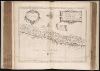
- Call Number:
- C16 015h
- Collection Title:
- Lhistoire dv Nouveau monde on Description des Indes Occidentales, contenant dix-huit liures / par
- Image Count:
- 1
- Found in:
- Beinecke Rare Book and Manuscript Library > Florida, et regiones vicinae
- Published / Created:
- 1640
- Call Number:
- C16 015h
- Collection Title:
- Lhistoire dv Nouveau monde on Description des Indes Occidentales, contenant dix-huit liures / par
- Image Count:
- 1
- Found in:
- Beinecke Rare Book and Manuscript Library > Nova Hispanica, Nova Galicia, Guatimala
- Published / Created:
- 1640
- Call Number:
- C16 015h
- Collection Title:
- Lhistoire dv Nouveau monde on Description des Indes Occidentales, contenant dix-huit liures / par
- Image Count:
- 1
- Found in:
- Beinecke Rare Book and Manuscript Library > Chili
- Published / Created:
- 1640
- Call Number:
- C16 015h
- Collection Title:
- Lhistoire dv Nouveau monde on Description des Indes Occidentales, contenant dix-huit liures / par
- Image Count:
- 1
- Found in:
- Beinecke Rare Book and Manuscript Library > Paraguay, O Prov. de Rio de la Plata cum adiacentibus Provinviis quas vocant Tucuman, et Sta. Cruz de la Sierra
- Published / Created:
- 1722
- Call Number:
- Zc52 +722pe
- Collection Title:
- Derrotero de la expedicion en la provincia de los Texas, nuevo reyno de Philipinas, que de orden
- Image Count:
- 2
- Resource Type:
- Maps, Atlases & Globes
- Found in:
- Beinecke Rare Book and Manuscript Library > Presidio de n.s. de Loreto en la Bahia
- Published / Created:
- 1739
- Call Number:
- WeInd Ehc 739
- Collection Title:
- A description of the Windward Passage, and Gulf of Florida, with the course of the British trading
- Image Count:
- 1
- Resource Type:
- Maps, Atlases & Globes
- Found in:
- Beinecke Rare Book and Manuscript Library > A chart of the Bahamas Islands with a description of the Gulf of Florida and Windward passage &c. referr'd from the figures here set down, to the general index annexed ... by J.C
- Creator:
- Jefferys, Thomas, d. 1771
- Published / Created:
- 1775 Feb 20
- Call Number:
- 1973 Folio 80
- Collection Title:
- The West-India atlas: or, A compendious description of the West-Indies: illustrated with forty
- Image Count:
- 1
- Resource Type:
- Prints & Photographs
- Found in:
- Beinecke Rare Book and Manuscript Library > The Virgin Islands from English and Danish surveys
- Creator:
- Jefferys, Thomas, d. 1771.
Keulen, Gerard van
- Published / Created:
- 1775 Feb 20
- Call Number:
- 1973 Folio 80
- Collection Title:
- The West-India atlas: or, A compendious description of the West-Indies: illustrated with forty
- Image Count:
- 1
- Resource Type:
- Prints & Photographs
- Found in:
- Beinecke Rare Book and Manuscript Library > Curacao from the Dutch originals of Gerard Van Keulen
- Call Number:
- WeInd Ehc 762J
- Collection Title:
- A description of the Spanish islands and settlements on the coast of the West Indies / compiled
- Image Count:
- 1
- Resource Type:
- Maps, Atlases & Globes
- Found in:
- Beinecke Rare Book and Manuscript Library > The island of Hispaniola called by the French St. Domingo. Subject to France and Spain
- Creator:
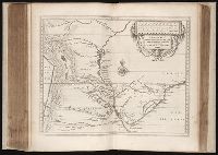
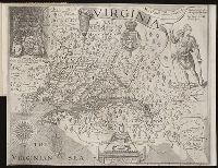
- Hole, William, d. 1624, engraver
Smith, John, 1580-1631.
- Call Number:
- Taylor 256
- Collection Title:
- A map of Virginia : vvith a description of the covntrey, the commodities, people, government and
- Image Count:
- 1
- Found in:
- Beinecke Rare Book and Manuscript Library > Virginia discouered and described by Captayn John Smith
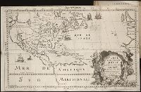
- Creator:
- Bouttats, Gaspard, b. ca. 1640, engraver
- Call Number:
- Pequot H41
- Collection Title:
- Aenmerckelycke historische reys-beschryvinge door verscheyde landen veel grooter als die van geheel
- Image Count:
- 1
- Found in:
- Beinecke Rare Book and Manuscript Library > Carte d'un nouueau monde, entre le nouueau Mexique et la mer glacialle
- Creator:
- Evans, Lewis, 1700?-1756
- Call Number:
- Egg +755E
- Collection Title:
- Geographical, historical, political, philosophical and mechanical essays : the first, containing an
- Image Count:
- 1
- Found in:
- Beinecke Rare Book and Manuscript Library > A general map of the middle British colonies in America