Skip to search
Skip to main content
Skip to first result
Search
You Searched For
"Latin"
Extent of Digitization
Partially digitized
Access
Public
Resource Type
Maps, Atlases & Globes
New Search
Search Results
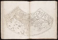
Published / Created:
[1490]
Call Number:
1978 Folio 114
Collection Title:
Cosmographia. [Translated into Latin by Jacobus Angelus, and edited by Nicolaus Germanus.]
Image Count:
1
Resource Type:
Maps, Atlases & Globes
Alternative Title:
[Geographia. Latin ]
Description:
First map after text.
Subject (Geographic):
Africa., Europe., Mediterranean Region, and Middle East.
Subject (Topic):
Incunabula in Yale Library
Collection Created:
[Rome, Petrus de Turre, November 4, 1490]
Found in:
Beinecke Rare Book and Manuscript Library > [Map depicting Europe, North Africa, the Middle East and Asia].
Creator:
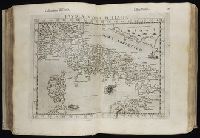
Published / Created:
[1599]
Call Number:
Gfp94 gi561e
Image Count:
12
Resource Type:
Maps, Atlases & Globes
Alternative Title:
Geografia di Clavdio Tolomeo Alessandrino and Geographia. Italian. 1599
Description:
First printed in Latin in Vicenza in
Publisher:
Appresso gli heredi di Melchior Sessa,
Subject (Geographic):
America--Geography--Maps
Subject (Name):
Rosaccio, Giuseppe, approximately 1530-approximately 1620, Ruscelli, Girolamo, -approximately 1565, and Thorne Collection of Cartogaphy and Geography Bookplate.
Subject (Topic):
Geography, Ancient--Maps and Mathematical geography
Found in:
Beinecke Rare Book and Manuscript Library > Geografia di Claudio Tolomeo Alessandrino [cartographic material] / tradotta di Greco nell'idioma volgare Italiano da Girolamo Ruscelli, et hora nuouamente ampliata da Gioseffo Rosaccio, con varie annotationi, & espositioni, & tauole di rame, che nelli stampati altre volte non erano, hauendo etiando poste à i lor luoghi le tauole vecchie, che prima confusamente giaceuano, et vna Geografia vniuersale del medesimo, separata da quella di Tolomeo; nella quale secondo il parere de' più moderni geografi, fedelmente sono poste le prouincie, regni, città, castelli, monti, fiumi, laghi, porti, golfi, isole, penisole, popoli, leggi, riti, & costumi di ciascuna città. Et vna breue descrittione di tutta la terra, distinta in quattro libri, nel primo de' quali si tratta dell'Europa; nel secondo dell'Africa; nel terza dell'Asia, nel quarto dell'America. Con due indici copiosissimi di tutto quello, che di notabile si contiene nell'opera.
Creator:
Published / Created:
1572]-1618
Call Number:
1975 Folio 41
Image Count:
1
Resource Type:
Maps, Atlases & Globes
Alternative Title:
Civitates orbis terrarum ...
Publisher:
[Coloniae Agrippinae,
Subject (Geographic):
Rome--Antiquities--Early works to 1800 and Rome--Antiquities--Maps
Subject (Topic):
Cities and towns, Medieval and Maps, Pictorial -- (LC)
Found in:
Beinecke Rare Book and Manuscript Library > Civitates orbis terrarvm ...
Creator:
Published / Created:
1597
Call Number:
1977 +400
Image Count:
2
Resource Type:
Maps, Atlases & Globes
Alternative Title:
Descriptionis Ptolemaicae augmentum
Description:
Engraved t.-p., within ornamental border., Errata: p. [1] at end., Imperfect: 2 p.l. and first map, "Orbis terrarum," wanting; autograph of Amadeus Canalius; unidentified bookplate: Sc. 8. D N. 28., and Signatures: [*]⁴ A-Aa⁴.
Publisher:
Tijpis Iohannis Bogardi,
Subject (Geographic):
America--Discovery and exploration., America--Early accounts to 1600., and America--Maps--Early works to 1800.
Subject (Name):
Canalius, Amadeus--Autograph.
Subject (Topic):
Early maps.
Found in:
Beinecke Rare Book and Manuscript Library > Descriptionis Ptolemaicae avgmentvm, siue Occidentis notitia breui commentario illustrata, studio et opera Cornely Wytfliet Louaniensis.
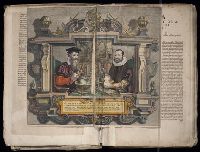
Published / Created:
Undated
Call Number:
1981 Folio 10
Collection Title:
Gerardi Mercatoris Atlas, sive, Cosmographicae meditationes de fabrica mundi et fabricati figura
Image Count:
1
Resource Type:
Maps, Atlases & Globes
Subject (Topic):
Atlases --Early works to 1800, Atlases, Dutch, and Geography --Early works to 1800
Collection Created:
[Amsterdam] : Sumptibus & typis aeneis Judoci Hondij, Amsterodami, 1613
Found in:
Beinecke Rare Book and Manuscript Library > Gerardus Mercator natus Iudocus Hondius natus ...
Creator:
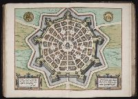
Published / Created:
1593
Call Number:
1975 Folio 41
Collection Title:
Civitates orbis terrarvm ...
Image Count:
1
Resource Type:
Maps, Atlases & Globes
Subject (Geographic):
Palmanova (Italy) --Buildings, structures, etc. --Designs and plans
Subject (Name):
Hierat, Anton, fl.1597-1627, Hogenberg, Abraham, fl. 1608-1653, and Hogenberg, Franz, d. 1590?
Subject (Topic):
Cities and towns, Medieval
Collection Created:
[Coloniae Agrippinae, 1572]-1618
Found in:
Beinecke Rare Book and Manuscript Library > Palma
Creator:
Published / Created:
ann. 1605.
Call Number:
1976 Folio 46
Image Count:
1
Resource Type:
Maps, Atlases & Globes
Alternative Title:
Mariners mirrour.
Description:
Map oriented with North at bottom left.
Publisher:
Jodocus Hondius excudit,
Subject (Geographic):
Great Britain --Maps --Early works to 1800, Netherlands --Maps --Early works to 1800, and North Sea --Maps --Early works to 1800
Found in:
Beinecke Rare Book and Manuscript Library > The mariners mirrovr wherin may playnly be seen the courses, heights, distances, depths, sounding, flouds and ebs, risings of lands, rocks ... of the harbouroughs, havens and ports of the greatest part of Europe: ... together w.th the rules and instrumeíÄ
Branch:v1.61.6 ,Deployed:2024-06-12T09:55:37-04:00