Search
You Searched For
Search Results
- Published / Created:
- Undated
- Call Number:
- 1973 Folio 56
- Collection Title:
- The American pilot, containing the navigation of the sea coast of North America, from the Streights
- Image Count:
- 1
- Resource Type:
- Maps, Atlases & Globes
- Subject (Geographic):
- Georgia and South Carolina
- Subject (Name):
- Norman, John, 1748?-1817 and Norman, William, d. 1807
- Subject (Topic):
- Nautical charts and Pilot guides --North America --Atlantic Coast
- Collection Created:
- Boston, Printed and sold by Wm. Norman at his office, no. 75 Newbury Street, MDCCXCIIII
- Found in:
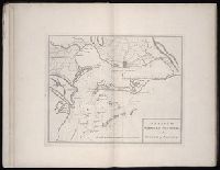
- Beinecke Rare Book and Manuscript Library > A chart of South Carolina and Georgia
- Creator:
- Bennett, John
Sayer, Robert, 1725-1794
- Call Number:
- 1977 Folio 78
- Collection Title:
- A New and accurate chart of the West-India Islands and coast, with the gulf passage through the New
- Image Count:
- 1
- Resource Type:
- Maps, Atlases & Globes
- Subject (Geographic):
- Caribbean Area., Central America., Cuba., Florida., Hispaniola., Jamaica., Louisiana., Puerto Rico., and West Indies
- Subject (Topic):
- Nautical charts
- Collection Created:
- London, Printed for Robert Sayer and John Bennett, Fleet-Street, 1779
- Found in:
- Beinecke Rare Book and Manuscript Library > A new general chart of the West Indies from the latest marine journals and surveys. Regulated and ascertained by astronomical observations
- Call Number:
- 1977 Folio 78
- Collection Title:
- A New and accurate chart of the West-India Islands and coast, with the gulf passage through the New
- Image Count:
- 1
- Resource Type:
- Maps, Atlases & Globes
- Alternative Title:
- Petit Guave in the island of Hispaniola, pl. 32
- Subject (Geographic):
- Hispaniola
- Subject (Topic):
- Nautical charts
- Collection Created:
- London, Printed for Robert Sayer and John Bennett, Fleet-Street, 1779
- Found in:
- Beinecke Rare Book and Manuscript Library > A plan of Fort St. Louis harbour on the south side of Hispaniola, pl. 31.
- Published / Created:
- 1753-81.
- Call Number:
- 1973 Folio 103
- Container / Volume:
- 6
- Image Count:
- 6
- Description:
- BEIN: Imperfect: v. 1-2, 4-5 wanting.
- Publisher:
- Johannes van Keulen
- Subject (Topic):
- Nautical charts, Pilot guides, and Atlases
- Found in:
- Beinecke Rare Book and Manuscript Library > De Nieuwe groote lichtende zee-fakkel ...
- Creator:
- Jefferys, Thomas, d. 1771
- Call Number:
- 1977 Folio 96
- Collection Title:
- The West-India atlas: or, A compendious description of the West-Indies: illustrated with forty
- Image Count:
- 1
- Resource Type:
- Maps, Atlases & Globes
- Subject (Geographic):
- Jamaica
- Subject (Topic):
- Nautical charts
- Collection Created:
- London, Printed for Robert Sayer and John Bennett, Fleet-Street, 1775
- Found in:
- Beinecke Rare Book and Manuscript Library > Jamaica from the latest surveys; improved and engraved by Thomas Jefferys geographer to the king
- Published / Created:
- 1703.
- Call Number:
- 1983 Folio 53
- Image Count:
- 12
- Description:
- BEIN: Beinecke copy imperfect: 6 p. of text wanting. (1983 Folio 53)
- Publisher:
- Chez Hubert Jaillot aux deux Globes [i.e. Pieter Mortier]
- Subject (Topic):
- Nautical charts and Sailing ships
- Found in:
- Beinecke Rare Book and Manuscript Library > Le Neptune françois, ou, Atlas nouveau des cartes marines : levées et gravées par ordre exprés du roy pour l'usage de ses armées de mer ...
- Creator:
- Robert Sayer and John Bennett (Firm)
- Published / Created:
- 1779
- Call Number:
- 1977 Folio 78
- Collection Title:
- A New and accurate chart of the West-India Islands and coast, with the gulf passage through the New
- Image Count:
- 1
- Resource Type:
- Maps, Atlases & Globes
- Alternative Title:
- A plan of Cape Nicola Mole, on the west end of Hispaniola from a French survey. pl. 34
- Description:
- Printed for R. Sayer and J. Bennet
- Subject (Geographic):
- Cuba., Hispaniola., and Port-au-Prince (Haiti)
- Subject (Topic):
- Nautical charts
- Collection Created:
- London, Printed for Robert Sayer and John Bennett, Fleet-Street, 1779
- Found in:
- Beinecke Rare Book and Manuscript Library > Leogane and Port au Prince in the island of Hispaniola. pl. 33
- Creator:
- Robert Sayer and John Bennett (Firm)
- Published / Created:
- 1779
- Call Number:
- 1977 Folio 78
- Collection Title:
- A New and accurate chart of the West-India Islands and coast, with the gulf passage through the New
- Image Count:
- 1
- Resource Type:
- Maps, Atlases & Globes
- Alternative Title:
- Plan of the Bay of Matanzas, on the north side of Cuba. pl. 24
- Description:
- Printed for R. Sayer and J. Bennet
- Subject (Geographic):
- Cuba. and Havana (Cuba)
- Subject (Topic):
- Nautical charts
- Collection Created:
- London, Printed for Robert Sayer and John Bennett, Fleet-Street, 1779
- Found in:
- Beinecke Rare Book and Manuscript Library > Plan of the city and harbour of Havanna. pl. 23
- Creator:
- Jefferys, Thomas, d. 1771
- Call Number:
- 1977 Folio 96
- Collection Title:
- The West-India atlas: or, A compendious description of the West-Indies: illustrated with forty
- Image Count:
- 1
- Resource Type:
- Maps, Atlases & Globes
- Subject (Geographic):
- Hispaniola
- Subject (Topic):
- Nautical charts
- Collection Created:
- London, Printed for Robert Sayer and John Bennett, Fleet-Street, 1775
- Found in:
- Beinecke Rare Book and Manuscript Library > South part of St. Domingo, of Hispaniola, by Thos Jeffreys geographer to his Majesty
- Creator:
- Speer, Joseph Smith, cartographer
- Published / Created:
- MDCCLXXI [1771]
- Call Number:
- 1973 Folio 67
- Image Count:
- 27
- Description:
- BEIN 1973 Folio 67: Armorial bookplate: John Bebb. Ms. corrections in text.
- Publisher:
- Printed for the author and sold by S. Hooper ...
- Subject (Geographic):
- West Indies, Caribbean Area, and Atlantic Coast (North America)
- Subject (Topic):
- Pilot guides, Harbors, and Nautical charts
- Found in:
- Beinecke Rare Book and Manuscript Library > The West-India pilot : containing piloting directions for Port Royal and Kingston harbours in Jamaica, in and out through the kays, &c. ... the true courses and distances through the windward passages ... courses, distances, and anchoring places from Jamaica to the Gulf of Florida ... : the whole illustrated with a number of maps and plans engraved by the best artists, describing the ports and bays above mentioned with the true soundings, laid down with the utmost exactness