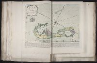
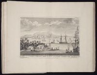
Lempriere, C., creator Toms, W. H. (William Henry), ca. 1700-ca. 1750
Published / Created:
1738?
Call Number:
2003 Folio 85
Image Count:
1
Description:
BEIN 2003 Folio 85: No. 33 of 45 maps bound together with binder's spine title: Atlas of America; ms. table of contents. Bookplate: Robinson. Bookplate of Paul Mellon., C. Lempriere delin., W.H. Thoms, sculp. Price 2s., Hand colored., is humbly dedicated by C. Lempriere and W.H. Thoms, 1738., Relief shown pictorially., and Scale [ca. 1:64,000].
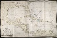
Bowen, Thomas, d. 1790 Speer, Joseph Smith., creator
Published / Created:
1774 May 20
Call Number:
1982 Folio 10
Image Count:
1
Alternative Title:
Chart of the West Indies
Description:
European possessions shown by color., Includes acknowledgement to Captain Speer by John Pownall, secry., Plantation Office, Whitehall, January 25, 1774 and Honorary gold medal., No. 41 of 43 maps bound together in composite atlas., Relief shown pictorially. Depths shown by soundings., Scale [ca. 1:5,000,000]., and Shows southern United States, Mexico, Central America, West Indies, Bermudas, and northern South America.
Publisher:
Capt. Speer
Subject (Geographic):
Caribbean Area --Maps --Early works to 1800 and West Indies --Maps --Early works to 1800
Chernyshov, Ivan Georgievich Dury, Andrew., creator Sayer, Robert, 1725-1794
Published / Created:
1787 October 24
Call Number:
1982 Folio 10
Image Count:
1
Alternative Title:
Map of the present seat of war, between the Russians, Poles, and Turk
Description:
Also shows parts of Hungary and Poland., Includes paste-on addition to northwestern sheet depicting Bosnia, Herzegovina, and the Dalmatian Coast., No. 26 of 43 maps bound together in composite atlas., Prime meridian: Ferro., Relief shown pictorially., Scale [ca. 1:2,500,000]., and Sheets mounted together to form 2 sheets.
Publisher:
Wm. Faden
Subject (Geographic):
Black Sea --Maps --Early works to 1800 and Russia --Maps --Early works to 1800
Subject (Topic):
Russo-Turkish War, 1787-1792 --Maps --Early works to 1800
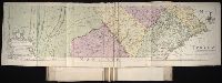
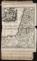
Map of the improved part of the province of Pennsylvania
Description:
BEIN 2003 Folio 85: No. 20 of 45 maps bound together with binder's spine title: Atlas of America; ms. table of contents. Bookplate: Robinson. Bookplate of Paul Mellon., Hand colored., Relief shown pictorially., Scale [ca. 1:250,000]., and Shows county boundaries.
Publisher:
Sold by the author, Nicholas Scull
Subject (Geographic):
Pennsylvania -- Administrative and political divisions -- Maps -- Early works to 1800 and Pennsylvania -- Maps -- Early works to 1800
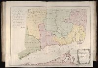
Lansdowne, William Petty, Marquis of, 1737-1805 Park, Moses, 1738-1828, creator
Published / Created:
1766
Call Number:
2003 Folio 85
Image Count:
1
Alternative Title:
Plan of the colony of Connecticut in North-America
Description:
Available also through the Library of Congress Web site as a raster image., BEIN 2003 Folio 85: No. 19 of 45 maps bound together with binder's spine title: Atlas of America; ms. table of contents. Bookplate: Robinson. Bookplate of Paul Mellon., Hand colored., LC Maps of North America, 1750-1789,, Relief shown pictorially., Scale [ca. 1:275,000]., and Shows counties, towns, rivers, and post roads.
Publisher:
s.n
Subject (Geographic):
Connecticut -- Administrative and political divisions -- Maps -- Early works to 1800 and Connecticut -- Maps -- Early works to 1800
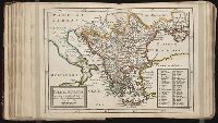
Twenty four new and accurate maps of the several parts of Europe ... : all (except the last) new
Image Count:
1
Alternative Title:
Turkey in Europe
Description:
In pencil on verso: 24. and Table of contents for maps 20-24 misnumbered.
Subject (Geographic):
Turkey --Maps
Subject (Name):
Barker, B. (Benjamin), d. 1764, bookseller, Clements, Henry, d. 1719, bookseller, King, Charles, d. 1735, bookseller, Nicholson, John, d. ca. 1717, bookseller, Parker, Richard, fl. 1692-1725, bookseller, and Tooke, Benjamin, d. 1716, bookseller
Subject (Topic):
Atlases --Early works to 1800
Collection Created:
[London] : Sold by J. Nicholson at the King’s-Arms in Little Britain, Benj. Barker and Charles King ..., Benj. Tooke ..., Hen. Clements ..., R. Parker and Ralph Smith under the Royal-Exchange ..., [1715?]
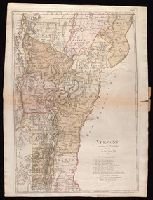
Bohn, Carl Ernst, publisher Ebeling, Christophe Daniel, 1741-1817. Erdbeschreibung und Geschichte von Amerika Schmidt, Paulus, engraver Sotzmann, D. F
Published / Created:
1796
Call Number:
1977 Folio 177
Image Count:
2
Resource Type:
Maps, Atlases & Globes
Description:
"Zu Ebelings Erdbeschreibung von Amerika.", Also shows county boundaries., Bar scales given in "Geographische Meilen 15 auf einen Grad" and "Englische meilen 69 4/25 auf einen Grad.", In upper right margin: No. XVI., Place names in German and English., Prime meridians: Greenwich and Washington., Relief shown by hachures., Sheet measures 72.8 x 54.3 cm. No. 10 of 34 maps bound together., and Watermark.
Publisher:
Bey Carl Ernst Bohn,
Subject (Geographic):
Vermont--Administrative and political divisions--Maps--Early works to 1800 and Vermont--Maps--Early works to 1800
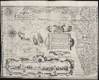
The West-India pilot: containing piloting directions for Port Royal and Kingston harbours in
Image Count:
1
Subject (Geographic):
Atlantic Ocean --Maps --Early works to 1800, Central America --Maps --Early works to 1800, and Honduras --Maps
Subject (Topic):
Harbors --Atlantic Coast (North America) --Maps --Early works to 1800, Nautical charts --Atlantic Coast (North America) --Early works to 1800, Nautical charts --Caribbean Area --Early works to 1800, Nautical charts --West Indies --Early works to 1800, Pilot guides --Atlantic Coast (North America) --Early works to 1800, Pilot guides --Caribbean Area --Early works to 1800, and Pilot guides --West Indies --Early works to 1800
Collection Created:
London : Printed for the author and sold by S. Hooper ..., MDCCLXXI [1771]