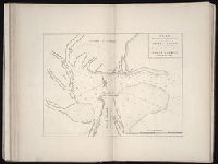
The West-India pilot: containing piloting directions for Port Royal and Kingston harbours in
Image Count:
1
Subject (Geographic):
Atlantic Ocean --Maps --Early works to 1800, Central America --Maps --Early works to 1800, Providence Island (Colombia) --Maps, and Santa Catalina Island (Colombia)
Subject (Topic):
Harbors --Atlantic Coast (NorthAmerica
Collection Created:
London : Printed for the author and sold by S. Hooper ..., MDCCLXXI [1771]
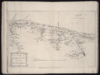
The West-India pilot: containing piloting directions for Port Royal and Kingston harbours in
Image Count:
1
Subject (Geographic):
Atlantic Ocean --Maps --Early works to 1800, Santo Domingo (Dominican Republic) --Maps --Early works to 1800, and West Indies --Maps --Early works to 1800
Subject (Topic):
Harbors --Atlantic Coast (NorthAmerica
Collection Created:
London : Printed for the author and sold by S. Hooper ..., MDCCLXXI [1771]
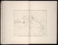
The West-India pilot: containing piloting directions for Port Royal and Kingston harbours in
Image Count:
1
Subject (Geographic):
Atlantic Ocean --Maps --Early works to 1800, Central America --Maps --Early works to 1800, and Mosquitia (Nicaragua and Honduras) --Maps --Early works to 1800
Subject (Topic):
Harbors --Atlantic Coast (NorthAmerica
Collection Created:
London : Printed for the author and sold by S. Hooper ..., MDCCLXXI [1771]