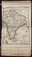
Anville, Jean Baptiste Bourguignon d', 1697-1782 Compagnie des Indes Jefferys, Thomas, d. 1771, creator Kitchin, Thomas, d. 1784 Robert Laurie and James Whittle Sayer, Robert, 1725-1794
Published / Created:
1789 January 1
Call Number:
1982 Folio 10
Image Count:
1
Description:
Also appeared in Kitchin's General atlas describing the whole universe. London : Printed for Robert Sayer, [1780]., Has illustrated cartouche and includes text., No. 36 of 43 maps bound together in composite atlas., Norwich, O.I. Norwich's maps of Africa., Prime meridians: Ferro and London., Relief shown pictorially; depths by soundings., Scale [ca. 1:1,850,000]., and This map is copied from an original drawn by Monsr. D'Anville at the expense of the French East India Company, & published at Paris. The country thorough [sic] which the R. Senegal runs has been improved & corrected from a large & curious survey of that river found in the Fort of Senegal.
Publisher:
Printed for by Robert Sayer
Subject (Geographic):
Africa, West --Maps --Early works to 1800
Subject (Topic):
Coasts --Africa, West --Maps --Early works to 1800
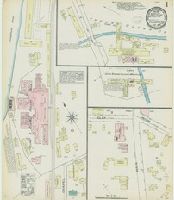
Sanborn fire insurance maps are a rich source of historic data on the urban built environment of North America during the 19th and early 20th centuries. The atlases were created for the purpose of underwriting fire insurance policies, which depended upon accurate and frequently-updated information about construction materials, municipal and transportation infrastructure, industrial and commercial landuse and more. The Yale University Library Map Department scanned its holdings of Sanborn fire insurance maps (consisting primarily of Connecticut towns) in order to make the maps more accessible.
Alternative Title:
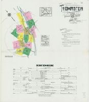
May 1884, Thomaston, Conn.
Description:
"2 sheets.", Contains information on population, prevailing winds, water facilities and fire department., Partial cadastral map., and SMLMAPL 766 T36 1884: Sheets disbound. "Triplicate" stamp on both sheets. Library of Congress copyright stamp on title sheet.
Subject (Geographic):
Thomaston (Conn.)--Maps
Subject (Name):
Library of Congress Stamp
Subject (Topic):
Fire risk assessment--Connecticut--Thomaston--Maps and Real property--Connecticut--Thomaston--Maps
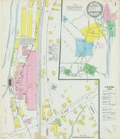
Sanborn fire insurance maps are a rich source of historic data on the urban built environment of North America during the 19th and early 20th centuries. The atlases were created for the purpose of underwriting fire insurance policies, which depended upon accurate and frequently-updated information about construction materials, municipal and transportation infrastructure, industrial and commercial landuse and more. The Yale University Library Map Department scanned its holdings of Sanborn fire insurance maps (consisting primarily of Connecticut towns) in order to make the maps more accessible.
Alternative Title:
Jan. 1890, Thomaston, Conn.
Description:
"3622. 3 sheets.", Contains information on population, prevailing winds, water facilities and fire department., Partial cadastral map., and SMLMAPL 766 T36 1890: Sheets disbound. "Triplicate" stamp on all sheets. Library of Congress copyright stamp on title sheet.
Subject (Geographic):
Thomaston (Conn.)--Maps
Subject (Name):
Library of Congress Stamp
Subject (Topic):
Fire risk assessment--Connecticut--Thomaston--Maps and Real property--Connecticut--Thomaston--Maps
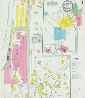
Sanborn fire insurance maps are a rich source of historic data on the urban built environment of North America during the 19th and early 20th centuries. The atlases were created for the purpose of underwriting fire insurance policies, which depended upon accurate and frequently-updated information about construction materials, municipal and transportation infrastructure, industrial and commercial landuse and more. The Yale University Library Map Department scanned its holdings of Sanborn fire insurance maps (consisting primarily of Connecticut towns) in order to make the maps more accessible.
Alternative Title:
Oct. 1895, Thomaston, Conn.
Description:
"6. 4 sheets.", Contains information on population, prevailing winds, water facilities and fire department., Includes index of specials., Partial cadastral map., and SMLMAPL 766 T36 1895: Sheets disbound. "Triplicate" stamp on all sheets. Library of Congress copyright stamp on title sheet.
Subject (Geographic):
Thomaston (Conn.)--Maps
Subject (Name):
Library of Congress Stamp
Subject (Topic):
Fire risk assessment--Connecticut--Thomaston--Maps and Real property--Connecticut--Thomaston--Maps
Sanborn fire insurance maps are a rich source of historic data on the urban built environment of North America during the 19th and early 20th centuries. The atlases were created for the purpose of underwriting fire insurance policies, which depended upon accurate and frequently-updated information about construction materials, municipal and transportation infrastructure, industrial and commercial landuse and more. The Yale University Library Map Department scanned its holdings of Sanborn fire insurance maps (consisting primarily of Connecticut towns) in order to make the maps more accessible.
Alternative Title:
Sep. 1900, Thomaston, Conn.
Description:
"4 sheets. 4187.", Contains information on population, prevailing winds, water facilities and fire department., Includes index of specials., Partial cadastral map., and SMLMAPL 766 T36 1900: Sheets disbound. "Triplicate" stamp on all sheets. Library of Congress copyright stamp on title sheet.
Subject (Geographic):
Thomaston (Conn.)--Maps
Subject (Name):
Library of Congress Stamp
Subject (Topic):
Fire risk assessment--Connecticut--Thomaston--Maps and Real property--Connecticut--Thomaston--Maps
Sanborn fire insurance maps are a rich source of historic data on the urban built environment of North America during the 19th and early 20th centuries. The atlases were created for the purpose of underwriting fire insurance policies, which depended upon accurate and frequently-updated information about construction materials, municipal and transportation infrastructure, industrial and commercial landuse and more. The Yale University Library Map Department scanned its holdings of Sanborn fire insurance maps (consisting primarily of Connecticut towns) in order to make the maps more accessible.
Alternative Title:
Dec. 1905, Thomaston, Conn.
Description:
"4 sheets. 8964.", Contains information on population, prevailing winds, water facilities and fire department., Includes index of streets and specials., Partial cadastral map., and SMLMAPL 766 T36 1905: Sheets disbound. "Triplicate" stamp on all sheets. Library of Congress copyright and Map Division stamps on title sheet.
Subject (Geographic):
Thomaston (Conn.)--Maps
Subject (Name):
Library of Congress Stamp and Library of Congress. Map Division Stamp
Subject (Topic):
Fire risk assessment--Connecticut--Thomaston--Maps and Real property--Connecticut--Thomaston--Maps
Sanborn fire insurance maps are a rich source of historic data on the urban built environment of North America during the 19th and early 20th centuries. The atlases were created for the purpose of underwriting fire insurance policies, which depended upon accurate and frequently-updated information about construction materials, municipal and transportation infrastructure, industrial and commercial landuse and more. The Yale University Library Map Department scanned its holdings of Sanborn fire insurance maps (consisting primarily of Connecticut towns) in order to make the maps more accessible.
Alternative Title:
Aug. 1911, Thomaston, Conn.
Description:
"3966. 5 sheets.", Contains information on population, prevailing winds, water facilities and fire department., Includes index of streets and specials., Partial cadastral map., and SMLMAPL 766 T36 1911: Sheets disbound. Library of Congress copyright stamp on title sheet.
Subject (Geographic):
Thomaston (Conn.)--Maps
Subject (Name):
Library of Congress Stamp
Subject (Topic):
Fire risk assessment--Connecticut--Thomaston--Maps and Real property--Connecticut--Thomaston--Maps
Sanborn fire insurance maps are a rich source of historic data on the urban built environment of North America during the 19th and early 20th centuries. The atlases were created for the purpose of underwriting fire insurance policies, which depended upon accurate and frequently-updated information about construction materials, municipal and transportation infrastructure, industrial and commercial landuse and more. The Yale University Library Map Department scanned its holdings of Sanborn fire insurance maps (consisting primarily of Connecticut towns) in order to make the maps more accessible.
Alternative Title:
Jan. 1924, Thomaston, Conn.
Description:
"16 sheets. (1401).", Contains information on population, prevailing winds, water facilities and fire department., Includes index of streets and specials., Partial cadastral map., and SMLMAPL 766 T36 1924: Sheets disbound. Library of Congress copyright stamp on title sheet.
Subject (Geographic):
Thomaston (Conn.)--Maps
Subject (Name):
Library of Congress Stamp
Subject (Topic):
Fire risk assessment--Connecticut--Thomaston--Maps and Real property--Connecticut--Thomaston--Maps