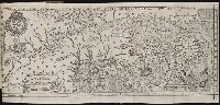
Jovrnal ou Description dv merveillevx voyage de Gvillavme Schovten, hollandois natif de Hoorn
Image Count:
1
Description:
Bound in facing p. 24., Imperfect: map has a defect just left of center in the form of a narrow vertical wrinkle that occurred at the time of printing, resulting in a line where no ink was deposited on the page, which also caused a small amount of loss of text., Map has several small brown and yellow marks on both the recto and verso., Map has small drop of black ink just left of the word "Latitudinis"., and Scale not given.
Subject (Geographic):
Horn, Cape (Chile), Le Maire Strait (Argentina), New Guinea --Maps --Early works to 1800, Oceania --Maps --Early works to 1800, and Tierra del Fuego (Argentina) --Maps --Early works to 1800
Subject (Name):
Schouten, Willem Corneliszoon, d. 1625
Collection Created:
A Amstredam : Chez Harman Ianson, marchand libraire, demeurant en la VVarmoes-straet, a le Sereine, 1619
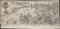
Jovrnal ou Description dv merveillevx voyage de Gvillavme Schovten, hollandois natif de Hoorn
Image Count:
1
Description:
Bound in facing p. 20., Map has several small brown marks on both the recto and verso as well as a larger one in the center that can be seen on both the recto and verso., and Scale not given.
Subject (Geographic):
Horn, Cape (Chile), Le Maire Strait (Argentina), and Tierra del Fuego (Argentina) --Maps --Early works to 1800
Subject (Name):
Schouten, Willem Corneliszoon, d. 1625
Collection Created:
A Amstredam : Chez Harman Ianson, marchand libraire, demeurant en la VVarmoes-straet, a le Sereine, 1619
Bound in after p. 224., Depicts coat of arms of Henry IV of France., In pencil on bottom left corner: 224., Map has several small brown marks on both the recto and verso., Map has small hole in left-most section just above a depiction of a pine cone., and Scale [ca. 1:9,428,600].
Subject (Geographic):
Acadia --Early works to 1800, America --Discovery and exploration --French --Early works to 1800, New France --Discovery and exploration --Early works to 1800, and New France --Maps --Early works to 1800
Subject (Name):
Villegaignon, Nicolas Durand de, 1510-1571?
Subject (Topic):
Indians of North America --Early works to 1800 and Indians of North America --Nova Scotia --Early works to 1800
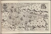
Bound in first after p. [48]., Depicts coat of arms of Henry IV of France., Drawn by Marc Lescarbot, made by Jan Swelinc, published by I. Millot., Immediately following Extraict du Privilege du Roy., Map has several small brown marks on both the recto and verso., Scale [ca. 1:9,428,600]., and Teaching resource: Professor John Mack Faragher, History 141: The American West.
Subject (Geographic):
Acadia --Early works to 1800, America --Discovery and exploration --French --Early works to 1800, New France --Discovery and exploration --Early works to 1800, and New France --Maps --Early works to 1800
Subject (Name):
Millot, Jean, b. 1582, printer, Swelinck, Jan, engraver, and Villegaignon, Nicolas Durand de, 1510-1571?
Subject (Topic):
Indians of North America --Early works to 1800 and Indians of North America --Nova Scotia --Early works to 1800
Bound in second after p. [48]., Depicts coat of arms of Henry IV of France and Mary I (Kingdom of Scotland)., Drawn by Marc Lescarbot, engraved by Jan Swelinck, published by I. Millot., Map has some small brown marks that can also be seen on the verso., Scale not given., and Teaching resource: Professor John Mack Faragher, History 141: The American West.
Subject (Geographic):
America --Discovery and exploration --French --Early works to 1800, New France --Discovery and exploration --Early works to 1800, and New France --Maps --Early works to 1800
Subject (Name):
Millot, Jean, b. 1582, printer, Swelinck, Jan, engraver, and Villegaignon, Nicolas Durand de, 1510-1571?
Bound in after p. 440., Depicts coat of arms of Henry IV of France and Mary I (Kingdom of Scotland)., Map has small brown mark on right-most edge that can also be seen on the verso., and Scale not given.
Subject (Geographic):
America --Discovery and exploration --French --Early works to 1800, New France --Discovery and exploration --Early works to 1800, and New France --Maps --Early works to 1800
Subject (Name):
Millot, Jean, b. 1582, printer, Swelinck, Jan, engraver
, and Villegaignon, Nicolas Durand de, 1510-1571?
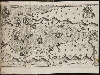
Descriptio ac delineatio geographica detectionis freti, sive, transitus ad occasum supra terras
Image Count:
1
Abstract:
Map depicts the Coat of Arms of the United Kingdom (era of the Union of the Crowns), reigning between the years 1603-1707.
Alternative Title:
Tabula nautica ...
Description:
Bound in after p. [6]., In ink on recto: place names "Okkak", "Nain"[?] and one longer handwritten note on the bottom margin., Map cut and folded irregularly., Map has been repaired with multiple pieces of tape on verso., Map has multiple small stains on both the recto and verso., Printed on recto in lower right corner: A1., and Scale [ca. 1:9,000,000].
Subject (Geographic):
North Atlantic Ocean --Maps --Early works to 1800
Subject (Name):
Hudson, Henry, d. 1611
Collection Created:
Amsterodami Ex officina Hesse lij Gerardi. Anno 1613