Bowen, Thomas, d. 1790 Speer, Joseph Smith., creator
Published / Created:
1774 May 20
Call Number:
1982 Folio 10
Image Count:
1
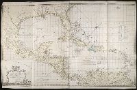
Alternative Title:
Chart of the West Indies
Description:
European possessions shown by color., Includes acknowledgement to Captain Speer by John Pownall, secry., Plantation Office, Whitehall, January 25, 1774 and Honorary gold medal., No. 41 of 43 maps bound together in composite atlas., Relief shown pictorially. Depths shown by soundings., Scale [ca. 1:5,000,000]., and Shows southern United States, Mexico, Central America, West Indies, Bermudas, and northern South America.
Publisher:
Capt. Speer
Subject (Geographic):
Caribbean Area --Maps --Early works to 1800 and West Indies --Maps --Early works to 1800
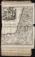
Chernyshov, Ivan Georgievich Dury, Andrew., creator Sayer, Robert, 1725-1794
Published / Created:
1787 October 24
Call Number:
1982 Folio 10
Image Count:
1
Alternative Title:
Map of the present seat of war, between the Russians, Poles, and Turk
Description:
Also shows parts of Hungary and Poland., Includes paste-on addition to northwestern sheet depicting Bosnia, Herzegovina, and the Dalmatian Coast., No. 26 of 43 maps bound together in composite atlas., Prime meridian: Ferro., Relief shown pictorially., Scale [ca. 1:2,500,000]., and Sheets mounted together to form 2 sheets.
Publisher:
Wm. Faden
Subject (Geographic):
Black Sea --Maps --Early works to 1800 and Russia --Maps --Early works to 1800
Subject (Topic):
Russo-Turkish War, 1787-1792 --Maps --Early works to 1800
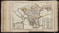
Twenty four new and accurate maps of the several parts of Europe ... : all (except the last) new
Image Count:
1
Alternative Title:
Turkey in Europe
Description:
In pencil on verso: 24. and Table of contents for maps 20-24 misnumbered.
Subject (Geographic):
Turkey --Maps
Subject (Name):
Barker, B. (Benjamin), d. 1764, bookseller, Clements, Henry, d. 1719, bookseller, King, Charles, d. 1735, bookseller, Nicholson, John, d. ca. 1717, bookseller, Parker, Richard, fl. 1692-1725, bookseller, and Tooke, Benjamin, d. 1716, bookseller
Subject (Topic):
Atlases --Early works to 1800
Collection Created:
[London] : Sold by J. Nicholson at the King’s-Arms in Little Britain, Benj. Barker and Charles King ..., Benj. Tooke ..., Hen. Clements ..., R. Parker and Ralph Smith under the Royal-Exchange ..., [1715?]
The generall historie of Virginia, New-England, and the Summer Iles : with the names of the
Image Count:
1
Abstract:
Inset depicting Powhatan.
Description:
Between p. 40-41. and Teaching resource: Professor John Mack Faragher, History 141: The American West.
Subject (Geographic):
Virginia --Maps --Early works to 1800
Subject (Topic):
Discoveries in geography, First contact of aboriginal peoples with Westerners, Indians of North America --Virginia --Early works to 1800, and Voyages and travels
Collection Created:
London : Printed by I.[ohn] D.[awson] and I.[ohn] H.[aviland] for Michael Sparkes, 1625
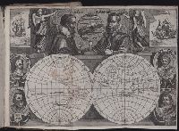
Journal ou relation exacte du voyage de Guill Schouten
Image Count:
1
Description:
Bound in after p. [8]., Busts of various explorers depicted around edges of map., Four small areas with stains on verso., Scale not given., and Western hemisphere of North and South America hand colored.
Subject (Topic):
Oceania --Discovery and exploration --Early works to 1800, Voyages around the world --Early works to 1800, and World maps --Early works to 1800
Collection Created:
A Paris : chez M. Gobert, au Palais en la gallerie des prisonniers, et les cartes, chez M. Tauernier, graueur du roy, demeurant au pont Marchand, 1618