A new discovery of a vast country in America : extending above four thousand miles, between New
Image Count:
1
Description:
Preceding Part 2, A Voyage through a vast country larger than Europe, lately discover'd betwixt the Frozen Sea and New Mexico. and Teaching resource: Professor John Mack Faragher, History 141: The American West.
Subject (Geographic):
United States --Discovery and exploration and United States --Maps --Early works to 1800
Subject (Name):
La Salle, Robert Cavelier, sieur de, 1643-1687
Collection Created:
London : Printed for M. Bentley, J. Tonson, H. Bonwick, T. Goodwin, and S. Manship, 1698
Also appeared in Faden's [General atlas. London : William Faden, 1811?]., No. 11 of 43 maps bound together in composite atlas., Relief shown pictorially., Scale [ca. 1:505,000]., and Shows forested areas, Banks of Flanders, etc.
Publisher:
William Faden
Subject (Geographic):
Belgium --Maps --Early works to 1800 and Luxembourg --Maps --Early works to 1800
Electorate of Brunswick-Luneburg with its dependencies
Description:
Imperfect: torn along fold, with some loss of text. Sheet measures 75.0 x 62.4 cm. No. 30 of 34 maps bound together., Inset map: Plan of the battle of Minden on the 1st of August 1759., Prime meridian: Ferro., and Relief shown pictorially.
Also appeared in Faden's [General atlas. London : William Faden, 1811?]., Imperfect: torn along some folds, with no loss of text., Includes ornamental cartouche., No. 16 of 43 maps bound together in composite atlas., Prime meridians: Ferro and London., Relief shown pictorially., Scale [ca. 1:2,850,000]., and Sheets fit together with overlap.
Papers relating to an act of the Assembly of the province of New-York, for encouragement of the
Image Count:
1
Alternative Title:
Map of the countrey of the Five Nations belonging to the province of New York and of the lakes near which the nations of far Indians live with part of Canada
Description:
Formerly bound preceding p. 1 of 2003 +64, now shelved separately as: Broadsides 2008 48.
Subject (Geographic):
Great Britain --Colonies --Commerce, Great Britain. Board of Trade, Great Britain. Sovereign (1714-1727 : George I), New York (State) --Commerce, New York (State) --Maps --Early works to 1800, New York (State). Act for encouragement of the Indian trade, and New York (State). Council
Subject (Name):
Colden, Cadwallader, 1688-1776 and L’Isle, Guillaume de, 1675-1726
Subject (Topic):
Fur trade --Canada, Fur trade --New York (State), and Indians of North America --Commerce
Collection Created:
[New York] : Printed and sold by William Bradford in the city of New-York, 1724
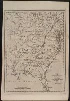
Jefferson, Thomas, 1743-1826 Jefferson, Thomas, 1743-1826. Notes on the state of Virginia Neele, Samuel John, 1758-1824, engraver Stockdale, John, 1749?-1814
Published / Created:
1787
Call Number:
1977 Folio 177
Image Count:
2
Resource Type:
Maps, Atlases & Globes
Description:
"The country on the eastern side of the Alleganey Mountains, is taken from Fry and Jefferson's Map of Virginia and Scull's Map of Pennsylvania ... that on the western side of the Alleganey, is taken from Hutchins ... additions have been made, where they could be made on sure ground.", From the author's Notes on the State of Virginia. 1787., Prime meridian: Philadelphia., Relief shown pictorially and by hachures., Sheet measures 66.3 x 60.3 cm. No. 1 of 34 maps bound together., and Shows boundaries.
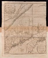
Carleton, Osgood, 1742-1816 Doolittle, Amos, 1754-1832, engraver Sullivan, James, 1744-1808. History of the district of Maine Thomas & Andrews
Published / Created:
1795
Call Number:
1977 Folio 177
Image Count:
2
Resource Type:
Maps, Atlases & Globes
Description:
In upper margin: Engraved for Judge Sullivan's History of the district of Maine., Includes references to land grants., Inset: [Southeastern Maine]. Scale [ca. 1:337,920]., Prime meridian: Washington, D.C., Relief shown by hachures., Sheet measures 54.0 x 44 cm. No. 11 of 34 maps bound together., and Shows town and county boundaries.
Publisher:
Thomas & Andrews,
Subject (Geographic):
Maine--Administrative and political divisions--Maps--Early works to 1800 and Maine--Maps--Early works to 1800