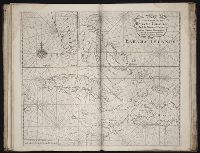
The English pilot: describing the sea-coasts, capes, head-lands, rivers, bays, roads, havens
Image Count:
1
Description:
Most maps numbered in pencil on verso, some on recto.
Subject (Geographic):
Atlantic Ocean --Maps --Early works to 1800 and Newfoundland and Labrador --Maps --Early works to 1800
Subject (Topic):
Navigation --Early works to 1800, Pilot guides --Atlantic Coast (U.S.) --Early works to 1800, and Pilot guides --Caribbean Area --Early works to 1800
Collection Created:
London : Printed for John Thornton, at the sign of the England, Scotland, and Ireland, in the Minories, and Richard Mount, at the Postern on Tower-Hill, 1698London : Printed for John Thornton, at the sign of the England, Scotland, and Ireland, in the Minories, and Richard Mount, at the Postern on Tower-Hill, 1698
Map of the world showing routes of Cook's expeditions, with notes on ice, wild life etc. seen. Relief shown pictorially; imaginary coastline for eastern coast of Australian Bight., No. 1 of 43 maps bound together in composite atlas., and Scale [ca.1:68 000 000].
Publisher:
Published by Wm. Faden, Geographer to the King, Charing Cross
Subject (Name):
Cook, James, 1728-1779 and Mulgrave, Constantine John Phipps, Lord
Subject (Topic):
Discoveries in geography --Maps --To 1800 and World maps --Early works to 1800
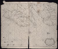
The English pilot: describing the West-India navigation, from Hudson's-Bay to the river Amazones
Image Count:
1
Subject (Geographic):
Africa --Maps --Early works to 1800, Atlantic Ocean --Maps --Early works to 1800, Central America --Maps --Early works to 1800, Great Britain --Maps --Early works to 1800, Newfoundland and Labrador --Maps --Early works to 1800, North America --Maps --Early works to 1800, South America --Maps --Early works to 1800, Spain --Maps --Early works to 1800, and West Indies --Maps --Early works to 1800
Subject (Topic):
Navigation --Early works to 1800, Pilot guides --Atlantic Coast (U.S.) --Early works to 1800, and Pilot guides --Caribbean Area --Early works to 1800
Collection Created:
London : Printed for W. and J. Mount, T. Page and son, on Tower-Hill, MDCCLX [1760]
The English pilot: describing the West-India navigation, from Hudson's-Bay to the river Amazones
Image Count:
1
Subject (Geographic):
Africa --Maps --Early works to 1800, Atlantic Ocean --Maps --Early works to 1800, Central America --Maps --Early works to 1800, Great Britain --Maps --Early works to 1800, Newfoundland and Labrador --Maps --Early works to 1800, North America --Maps --Early works to 1800, South America --Maps --Early works to 1800, Spain --Maps --Early works to 1800, and West Indies --Maps --Early works to 1800
Subject (Topic):
Navigation --Early works to 1800, Pilot guides --Atlantic Coast (U.S.) --Early works to 1800, and Pilot guides --Caribbean Area --Early works to 1800
Collection Created:
London : Printed for Thomas Page, William and Fisher Mount, in Postern-Row on Tower-hill, MDCCXXV [1725]
The English pilot: describing the West-India navigation, from Hudson's-Bay to the river Amazones
Image Count:
1
Subject (Geographic):
Africa --Maps --Early works to 1800, Atlantic Ocean --Maps --Early works to 1800, Central America --Maps --Early works to 1800, Great Britain --Maps --Early works to 1800, Newfoundland and Labrador --Maps --Early works to 1800, North America --Maps --Early works to 1800, South America --Maps --Early works to 1800, Spain --Maps --Early works to 1800, and West Indies --Maps --Early works to 1800
Subject (Topic):
Navigation --Early works to 1800, Pilot guides --Atlantic Coast (U.S.) --Early works to 1800, and Pilot guides --Caribbean Area --Early works to 1800
Twenty four new and accurate maps of the several parts of Europe ... : all (except the last) new
Image Count:
1
Alternative Title:
Europe in particular
Description:
In pencil on verso: 2.
Subject (Geographic):
Europe --Maps --Early works to 1800
Subject (Name):
Barker, B. (Benjamin), d. 1764, bookseller, Clements, Henry, d. 1719, bookseller, King, Charles, d. 1735, bookseller, Nicholson, John, d. ca. 1717, bookseller, Parker, Richard, fl. 1692-1725, bookseller, and Tooke, Benjamin, d. 1716, bookseller
Subject (Topic):
Atlases --Early works to 1800
Collection Created:
[London] : Sold by J. Nicholson at the King’s-Arms in Little Britain, Benj. Barker and Charles King ..., Benj. Tooke ..., Hen. Clements ..., R. Parker and Ralph Smith under the Royal-Exchange ..., [1715?]
Twenty four new and accurate maps of the several parts of Europe ... : all (except the last) new
Image Count:
1
Alternative Title:
France in general
Description:
In pencil on verso: 15.
Subject (Geographic):
France --Maps --Early works to 1800
Subject (Name):
Barker, B. (Benjamin), d. 1764, bookseller, Clements, Henry, d. 1719, bookseller, King, Charles, d. 1735, bookseller, Nicholson, John, d. ca. 1717, bookseller, Parker, Richard, fl. 1692-1725, bookseller, and Tooke, Benjamin, d. 1716, bookseller
Subject (Topic):
Atlases --Early works to 1800
Collection Created:
[London] : Sold by J. Nicholson at the King’s-Arms in Little Britain, Benj. Barker and Charles King ..., Benj. Tooke ..., Hen. Clements ..., R. Parker and Ralph Smith under the Royal-Exchange ..., [1715?]
Bar scales given in "great French leagues," "common French leagues," and "British miles"., Prime meridian: Paris., Relief shown pictorially., Sheet measures 55.6 x 73.6 cm. No. 16 of 34 maps bound together., and Watermark.
Publisher:
Printed for Robert Sayer,
Subject (Geographic):
France--Administrative and political divisions--Maps--Early works to 1800 and France--Maps--Early works to 1800