Search
You Searched For
Search Results
- Creator:
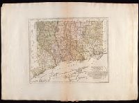
- Bohn, Carl Ernst
Ebeling, Christophe Daniel, 1741-1817. Erdbeschreibung und Geschichte von Amerika
Schmidt, Paulus, engraver
Sotzmann, D. F
- Published / Created:
- 1796
- Call Number:
- 1977 Folio 177
- Image Count:
- 2
- Resource Type:
- Maps, Atlases & Globes
- Found in:
- Beinecke Rare Book and Manuscript Library > Connecticut / entworfen von D.F. Sotzmann ; P. Schmidt, sculp.
- Published / Created:
- 1808
- Call Number:
- 1978 Folio 34
- Collection Title:
- Smith's New general atlas, containing distinct maps of all the principal empires, kingdoms
- Image Count:
- 1
- Resource Type:
- Maps, Atlases & Globes
- Found in:
- Beinecke Rare Book and Manuscript Library > Eastern Hemisphere
- Creator:
- Lotter, Tobias Conrad, 1717-1777, engraver
Seutter, Matthaeus, 1678-1756
- Published / Created:
- 174-?]
- Call Number:
- 1977 Folio 177
- Image Count:
- 3
- Resource Type:
- Maps, Atlases & Globes
- Found in:
- Beinecke Rare Book and Manuscript Library > Electoratus Hanoverani cum ditionibus et praefecturis suis / [cartographic material] / nova et accurata delin. curata a Matth. Seuttero, geogra. caes.
- Creator:
- Seale, Richard William
- Published / Created:
- [1783?]
- Call Number:
- 1977 Folio 177
- Image Count:
- 4
- Resource Type:
- Maps, Atlases & Globes
- Found in:
- Beinecke Rare Book and Manuscript Library > England and Ireland : containing all the cities, boroughs, markettowns & principal villages : with the coast of France from Calais to Brest delineated and engraved from actual surveys / by Richard William Seale.
- Creator:
- Cleveland and Toledo Railroad Company
- Published / Created:
- 1859]
- Call Number:
- BrSides Zc49 859cL
- Image Count:
- 1
- Resource Type:
- Maps, Atlases & Globes
- Found in:
- Beinecke Rare Book and Manuscript Library > For Pike's Peak and the gold mines, via Cleveland & Toledo Rail Road. A direct and all rail road line to St. Joseph, Kansas T
- Creator:
- Gunn, O. B. (Otis Berthoude), 1828-1901
- Published / Created:
- 1859
- Call Number:
- Zc39 859gu
- Collection Title:
- New map and hand-book of Kansas & the gold mines : containing descriptions and statistics of the
- Image Count:
- 1
- Resource Type:
- Maps, Atlases & Globes
- Found in:
- Beinecke Rare Book and Manuscript Library > Gunn's new map of Kansas and the gold mines
- Published / Created:
- March 1, 1809
- Call Number:
- 1978 226
- Collection Title:
- A new royal atlas, illustrative of the various divisions which comprise the surface of the globe...
- Image Count:
- 1
- Resource Type:
- Maps, Atlases & Globes
- Found in:
- Beinecke Rare Book and Manuscript Library > Hindoostan
- Published / Created:
- January 6, 1808
- Call Number:
- 1978 Folio 34
- Collection Title:
- Smith's New general atlas, containing distinct maps of all the principal empires, kingdoms
- Image Count:
- 1
- Resource Type:
- Maps, Atlases & Globes
- Found in:
- Beinecke Rare Book and Manuscript Library > Hindoostan
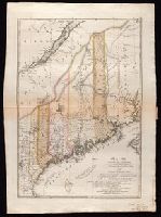
- Creator:
- Bohn, Carl Ernst
Ebeling, Christophe Daniel, 1741-1817. Erdbeschreibung und Geschichte von Amerika
Sander, Wilhelm, 1766-1836, engraver
Sotzmann, D. F
- Published / Created:
- 1798
- Call Number:
- 1977 Folio 177
- Image Count:
- 2
- Resource Type:
- Maps, Atlases & Globes
- Found in:
- Beinecke Rare Book and Manuscript Library > Maine / entworfen von D.F. Sotzmann ; Sander, sc.
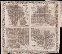
- Creator:
- Disturnell, John, 1801-1877
- Published / Created:
- 1851
- Call Number:
- Ne92 A18 D64 1851
- Collection Title:
- Disturnell's American and European railway and steamship guide; giving the arrangements on all the
- Image Count:
- 1
- Resource Type:
- Maps, Atlases & Globes
- Found in:
- Beinecke Rare Book and Manuscript Library > Map of New York, Philadelphia, Baltimore and Boston