"Dedié au roy, parson tres humb', tres-obeissa[n]t, tres fidele sujet et serviteur Hubert Iaillot.", "S[imonneau] f[ecit].", Appears in Jaillot's Atlas françois; cf. Pastoureau, M. Les atlas français, A.-H. Jaillot, II A 94 (with map date 169[-])., Includes five bar scales., Prime meridian: Ferro., Relief shown pictorially., and Stamps on verso: 205 [crossed out]; 337. Stamped title on verso. Backed with linen. Sheet measures 51.4 x 70.5 cm. No. 25 of 34 maps bound together.
Publisher:
Chez H. Iaillot geographe ordinaire du roy proche les grands Augustins aux 2. globes, avec privilege de S. Maj[es]té,
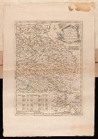
Appears in Jaillot's Atlas françois; cf. Pastoureau, M. Les atlas français, A.-H. Jaillot, II B 123 (with map date 1696)., Bar scale given in "échelle de lieues d'une heure de Chemin"., Place names in French and German., Prime meridian: Ferro., Relief shown pictorially., and Stamp on verso: 204. Title in ms. on verso. Backed with linen. Sheet measures 50.7 x 66.4 cm. No. 23 of 34 maps bound together.
Publisher:
Chez l'auteur joignant les grands Augustins aux deux globes,
Subject (Geographic):
Rhineland-Palatinate (Germany)--Maps--Early works to 1800
Bohn, Carl Ernst, publisher Ebeling, Christophe Daniel, 1741-1817. Erdbeschreibung und Geschichte von Amerika Sander, Wilhelm, 1766-1836, engraver Sotzmann, D. F
Published / Created:
1797
Call Number:
1977 Folio 177
Image Count:
2
Resource Type:
Maps, Atlases & Globes
Description:
"W. Sander sc.", "Zu Ebelings Erdbeschreibung von Amerika.", Also shows county boundaries., Bar scales given in "Geographische Meilen 15 auf einen Grad" and "Englische meilen 69 4/25 auf einen Grad.", In upper right margin: No. IX., Place names in German and English., Prime meridians: Greenwich and Washington., Relief shown by hachures., Sheet measures 53.9 x 74.7 cm. No. 3 of 34 maps bound together., and Watermark.
Publisher:
Bey Carl Ernst Bohn,
Subject (Geographic):
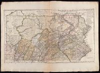
Pennsylvania--Administrative and political divisions--Maps--Early works to 1800 and Pennsylvania--Maps--Early works to 1800
Bohn, Carl Ernst Ebeling, Christophe Daniel, 1741-1817. Erdbeschreibung und Geschichte von Amerika Kliewer, Heinrich, engraver Sotzmann, D. F
Published / Created:
1797
Call Number:
1977 Folio 177
Image Count:
2
Resource Type:
Maps, Atlases & Globes
Description:
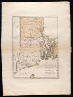
"Zu Ebelings Erdbeschreibung von Amerika.", Bar scales given in "Geographische Meilen 15 auf einen Grad" and "Englische meilen 69 4/25 auf einen Grad.", In upper right margin: No. V., Prime meridians: Greenwich and Washington., Relief shown by hachures. Depths shown by soundings., Sheet measures 72.3 x 53.5 cm. No. 7 of 34 maps bound together., and Watermark.
Publisher:
Bey Carl Ernst Bohn,
Subject (Geographic):
Rhode Island--Administrative and political divisions--Maps--Early works to 1800 and Rhode Island--Maps--Early works to 1800
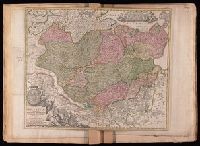
Tabvla generalis Holsatiae complectens Holsatiae, Dithmarsiae, Stormariae, et Vagriae Dvcatvs
Description:
Bar scales given in "milliaria Germanica communia" and "milliaria Gallica sive horae itinerariae"., Includes coat-of-arms and ill., Prime meridian: Ferro., Relief shown pictorially., and Stamps on verso: 144 [crossed out]; 263. Title in ms. on verso. Backed with linen. Sheet measures 48.0 x 57.1 cm. No. 24 of 34 maps bound together.
Publisher:
[Johann Baptist Homann,
Subject (Geographic):
Schleswig-Holstein (Germany)--Maps--Early works to 1800
Plan of the country where the Prussian army gained a victory over the Austrians, Oct. 1, 1756. and Routes of the Prussian Armies into Bohemia
Description:
Bar scales given in "English miles 69 1/2 to a degree," "German miles 15 in a degree," and "Bohemian or gr ms. of Silesia 12 in a Deg.", Prime meridians: London and Ferro., Sheet measures 50.3 x 34.6 cm. No. 14 of 34 maps bound together., and With inset map: Plan of the country where the Prussian army gained a victory over the Austrians, Oct. 1, 1756.
Publisher:
T. Jeffreys,
Subject (Geographic):
Bohemia (Czech Republic)--Maps--Early works to 1800
Subject (Topic):
Seven Years' War, 1756-1763--Maps--Early works to 1800
Bar scales given in "lieues d'une heure de chemin" and "miles d'Allemagne 16 au degré"., Imperfect: portions of cartouche cut-out, with some loss of text. Sheet measures 54.5 x 70.0 cm. No. 27 of 34 maps bound together., Inset: Plan de Breslaw, Capitale de la Silesie, scale [ca. 1:11,000], 15 x 21.4 cm., Prime meridian: Ferro., Relief shown pictorially., and Watermark.