Skip to search
Skip to main content
Skip to first result
Search
You Searched For
Date
Unknown
Extent of Digitization
Unspecified
Access
Public
Genre
Maps
Date Created
[Missing]
New Search
Search Results
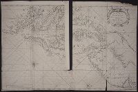
Creator:
Call Number:
1973 Folio 76
Collection Title:
The English pilot: describing the sea-coasts, capes, head-lands, rivers, bays, roads, havens
Image Count:
1
Description:
Most maps numbered in pencil on verso, some on recto.
Subject (Geographic):
Atlantic Ocean --Maps --Early works to 1800, Maryland --Maps --Early works to 1800, New Jersey --Maps --Early works to 1800, and Virginia --Maps --Early works to 1800
Subject (Topic):
Navigation --Early works to 1800, Pilot guides --Atlantic Coast (U.S.) --Early works to 1800, and Pilot guides --Caribbean Area --Early works to 1800
Collection Created:
London : Printed for John Thornton, at the sign of the England, Scotland, and Ireland, in the Minories, and Richard Mount, at the Postern on Tower-Hill, 1698London : Printed for John Thornton, at the sign of the England, Scotland, and Ireland, in the Minories, and Richard Mount, at the Postern on Tower-Hill, 1698
Found in:
Beinecke Rare Book and Manuscript Library > Virginia, Maryland, Pennsilvania, east & west New Jarsey
Call Number:
Ck44 23
Collection Title:
Kort beskrifning om provincien Nya Swerige uti America : som nu foertjden af the Engelske kallas
Image Count:
1
Description:
Between p. 52 & p. 53., Engraved by Holm, Thomas Campanius, ca. 1670-1702., and Teaching resource: Professor John Mack Faragher, History 141: The American West.
Subject (Geographic):
New England --Maps --Early works to 1800, United States --Maps --Early works to 1800, and Virginia --Maps --Early works to 1800
Collection Created:
Stockholm : Tryckt uti Kongl. boktr. hos S. Wankijfs ankia, med egen bekostnad, af J. H. Werner, 1702
Found in:
Beinecke Rare Book and Manuscript Library > Virginiae N. Angliae N. Hollandiae nec non Nova Sueviae delineatio
Published / Created:
undated
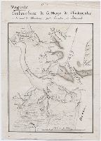
Call Number:
GEN MSS 499
Collection Title:
Henri Crublier d'Opterre journal and maps, [1776]-1783
Container / Volume:
Bsd folder 16
Image Count:
1
Subject (Geographic):
America--Maps--Early works to 1800 and United States--History--Revolution, 1775-1783--Maps--Early works to 1800.
Found in:
Beinecke Rare Book and Manuscript Library > Virginie. Embouchure de la Baye de Chesapeake
Creator:
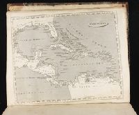
Call Number:
1974 +231
Collection Title:
A new and elegant general atlas, comprising all the new discoveries, to the present time
Image Count:
1
Description:
Map 60 from table of contents.
Subject (Geographic):
Central America--Maps, Cuba--Maps, Mexico--Maps, North America--Maps, Spain--Territories and possessions--Maps, and West Indies--Maps
Collection Created:
Philadelphia, J. Conrad & co., Baltimore, M. & J. Conrad & co. [etc., etc.] 1804
Found in:
Beinecke Rare Book and Manuscript Library > West Indies
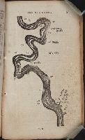
Call Number:
Zc20 802crc
Collection Title:
The navigator; or, The traders' useful guide in navigating the Monongahela, Allegheny, Ohio, and
Image Count:
1
Description:
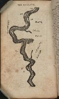
P. 55.
Subject (Geographic):
Chickasaw Bluffs (Tenn.), Mississippi River --Description and travel, Mississippi River --Maps, Mississippi River --Navigation, and Tennessee
Collection Created:
Pittsburgh, From the Press of Zadok Cramer, 1806
Found in:
Beinecke Rare Book and Manuscript Library > [A portion of the Mississippi River, including Chickasaw Bluffs]
Call Number:
Zc20 802crc
Collection Title:
The navigator; or, The traders' useful guide in navigating the Monongahela, Allegheny, Ohio, and
Image Count:
1
Description:
P. 72.
Subject (Geographic):
Mississippi, Mississippi River --Description and travel, Mississippi River --Maps, Mississippi River --Navigation, and Natchez (Miss.)
Collection Created:
Pittsburgh, From the Press of Zadok Cramer, 1806
Found in:
Beinecke Rare Book and Manuscript Library > [A portion of the Mississippi River, including Natchez]
Call Number:
1974 +231
Collection Title:
A new and elegant general atlas, comprising all the new discoveries, to the present time
Image Count:
1
Description:
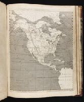
Map 36 from table of contents.
Subject (Geographic):
North America--Maps
Collection Created:
Philadelphia, J. Conrad & co., Baltimore, M. & J. Conrad & co. [etc., etc.] 1804
Found in:
Beinecke Rare Book and Manuscript Library > [Map of North America]
Creator:
Call Number:
1974 +231
Collection Title:
A new and elegant general atlas, comprising all the new discoveries, to the present time
Image Count:
1
Description:
Map 57 from table of contents.
Subject (Geographic):
Louisiana Purchase--Pictorial works, Louisiana--Maps--1804, and North America--Maps
Collection Created:
Philadelphia, J. Conrad & co., Baltimore, M. & J. Conrad & co. [etc., etc.] 1804
Found in:
Beinecke Rare Book and Manuscript Library > [Map of the Louisiana Territory]
Call Number:
1974 +231
Collection Title:
A new and elegant general atlas, comprising all the new discoveries, to the present time
Image Count:
1
Description:
Map 37 from table of contents.
Subject (Geographic):
North America--Maps and United States--Maps--1804
Collection Created:
Philadelphia, J. Conrad & co., Baltimore, M. & J. Conrad & co. [etc., etc.] 1804
Found in:
Beinecke Rare Book and Manuscript Library > [Map of the United States of America]
Call Number:
Taylor 58
Collection Title:
Praeclara Ferdinadi. Cortesii de noua maris Oceani Hyspania narratio ... Carolo Romanoru imperatori
Image Count:
1
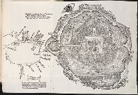
Description:
Preceding Argumentum Libri. and Teaching resource: Professor John Mack Faragher, History 141: The American West.
Subject (Geographic):
Mexico City (Mexico) and Mexico --History --Conquest, 1519-1540
Subject (Name):
Savorgnano, Pietro
Collection Created:
Norimberga, 1524
Found in:
Beinecke Rare Book and Manuscript Library > [Untitled map of Tenochtitlan]
Branch:v1.61.8 ,Deployed:2024-06-20T11:14:46-04:00