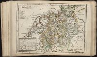
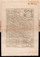
Twenty four new and accurate maps of the several parts of Europe ... : all (except the last) new
Image Count:
1
Alternative Title:
The north-west part of Germany, containing Cologne, Westphalia, Juliers, Cleeves, Munster, Osnaburgh, Holstein, Bremen, Hanover, Lunenburgh and Brunswick, Hesse-Cassel, &c
Description:
In pencil on verso: 9.
Subject (Geographic):
Bremen (Germany) --Maps, Cologne (Germany) --Maps --Early works to 1800, Emden (Lower Saxony, Germany) --Maps, Germany --Maps --Early works to 1800, Hesse-Kassel (Electorate), Muenster (Germany : Regierungsbezirk) --Maps, Osnabrueck (Germany) --Maps, and Westphalia (Germany) --Maps
Subject (Name):
Barker, B. (Benjamin), d. 1764, bookseller, Clements, Henry, d. 1719, bookseller, King, Charles, d. 1735, bookseller, Nicholson, John, d. ca. 1717, bookseller, Parker, Richard, fl. 1692-1725, bookseller, and Tooke, Benjamin, d. 1716, bookseller
Subject (Topic):
Atlases --Early works to 1800
Collection Created:
[London] : Sold by J. Nicholson at the King’s-Arms in Little Britain, Benj. Barker and Charles King ..., Benj. Tooke ..., Hen. Clements ..., R. Parker and Ralph Smith under the Royal-Exchange ..., [1715?]
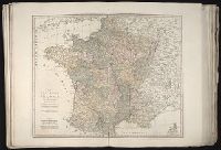
Also appeared in Kitchin's General atlas describing the whole universe. London : Printed Robert Sayer and J. Bennet, 1773; and General atlas describing the whole universe. London : Printed and sold for R. Sayer and J. Bennet, 1780., Ferro meridian., France divided into regions., From the map of Jaillot., No. 12 of 43 maps bound together in composite atlas., Relief shown pictorially., Scale [1:2,250,000]., and Shows boundaries, rivers, roads with distances and settlements.
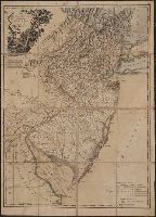
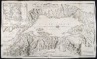
Plan of the country where the Prussian army gained a victory over the Austrians, Oct. 1, 1756. and Routes of the Prussian Armies into Bohemia
Description:
Bar scales given in "English miles 69 1/2 to a degree," "German miles 15 in a degree," and "Bohemian or gr ms. of Silesia 12 in a Deg.", Prime meridians: London and Ferro., Sheet measures 50.3 x 34.6 cm. No. 14 of 34 maps bound together., and With inset map: Plan of the country where the Prussian army gained a victory over the Austrians, Oct. 1, 1756.
Publisher:
T. Jeffreys,
Subject (Geographic):
Bohemia (Czech Republic)--Maps--Early works to 1800
Subject (Topic):
Seven Years' War, 1756-1763--Maps--Early works to 1800
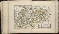
Twenty four new and accurate maps of the several parts of Europe ... : all (except the last) new
Image Count:
1
Alternative Title:
Swabia and Franconia, with the Duke of Marlborough's march to Hochstet, &c
Description:
In pencil on verso: 12.
Subject (Geographic):
Franconia (Germany) --Maps, Germany --Maps --Early works to 1800, and Swabia (Germany) --Maps --Early works to 1800
Subject (Name):
Barker, B. (Benjamin), d. 1764, bookseller, Clements, Henry, d. 1719, bookseller, King, Charles, d. 1735, bookseller, Nicholson, John, d. ca. 1717, bookseller, Parker, Richard, fl. 1692-1725, bookseller, and Tooke, Benjamin, d. 1716, bookseller
Subject (Topic):
Atlases --Early works to 1800
Collection Created:
[London] : Sold by J. Nicholson at the King’s-Arms in Little Britain, Benj. Barker and Charles King ..., Benj. Tooke ..., Hen. Clements ..., R. Parker and Ralph Smith under the Royal-Exchange ..., [1715?]