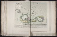
Bar scales given in "lieues d'une heure de chemin" and "miles d'Allemagne 16 au degré"., Imperfect: portions of cartouche cut-out, with some loss of text. Sheet measures 54.5 x 70.0 cm. No. 27 of 34 maps bound together., Inset: Plan de Breslaw, Capitale de la Silesie, scale [ca. 1:11,000], 15 x 21.4 cm., Prime meridian: Ferro., Relief shown pictorially., and Watermark.
Lempriere, C., creator Toms, W. H. (William Henry), ca. 1700-ca. 1750
Published / Created:
1738?
Call Number:
2003 Folio 85
Image Count:
1
Description:
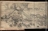
BEIN 2003 Folio 85: No. 33 of 45 maps bound together with binder's spine title: Atlas of America; ms. table of contents. Bookplate: Robinson. Bookplate of Paul Mellon., C. Lempriere delin., W.H. Thoms, sculp. Price 2s., Hand colored., is humbly dedicated by C. Lempriere and W.H. Thoms, 1738., Relief shown pictorially., and Scale [ca. 1:64,000].
Bowen, Thomas, d. 1790 Speer, Joseph Smith., creator
Published / Created:
1774 May 20
Call Number:
1982 Folio 10
Image Count:
1
Alternative Title:
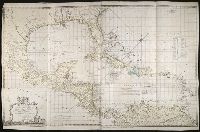
Chart of the West Indies
Description:
European possessions shown by color., Includes acknowledgement to Captain Speer by John Pownall, secry., Plantation Office, Whitehall, January 25, 1774 and Honorary gold medal., No. 41 of 43 maps bound together in composite atlas., Relief shown pictorially. Depths shown by soundings., Scale [ca. 1:5,000,000]., and Shows southern United States, Mexico, Central America, West Indies, Bermudas, and northern South America.
Publisher:
Capt. Speer
Subject (Geographic):
Caribbean Area --Maps --Early works to 1800 and West Indies --Maps --Early works to 1800
Chernyshov, Ivan Georgievich Dury, Andrew., creator Sayer, Robert, 1725-1794
Published / Created:
1787 October 24
Call Number:
1982 Folio 10
Image Count:
1
Alternative Title:
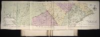
Map of the present seat of war, between the Russians, Poles, and Turk
Description:
Also shows parts of Hungary and Poland., Includes paste-on addition to northwestern sheet depicting Bosnia, Herzegovina, and the Dalmatian Coast., No. 26 of 43 maps bound together in composite atlas., Prime meridian: Ferro., Relief shown pictorially., Scale [ca. 1:2,500,000]., and Sheets mounted together to form 2 sheets.
Publisher:
Wm. Faden
Subject (Geographic):
Black Sea --Maps --Early works to 1800 and Russia --Maps --Early works to 1800
Subject (Topic):
Russo-Turkish War, 1787-1792 --Maps --Early works to 1800
Map of the improved part of the province of Pennsylvania
Description:
BEIN 2003 Folio 85: No. 20 of 45 maps bound together with binder's spine title: Atlas of America; ms. table of contents. Bookplate: Robinson. Bookplate of Paul Mellon., Hand colored., Relief shown pictorially., Scale [ca. 1:250,000]., and Shows county boundaries.
Publisher:
Sold by the author, Nicholas Scull
Subject (Geographic):
Pennsylvania -- Administrative and political divisions -- Maps -- Early works to 1800 and Pennsylvania -- Maps -- Early works to 1800
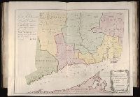
Lansdowne, William Petty, Marquis of, 1737-1805 Park, Moses, 1738-1828, creator
Published / Created:
1766
Call Number:
2003 Folio 85
Image Count:
1
Alternative Title:
Plan of the colony of Connecticut in North-America
Description:
Available also through the Library of Congress Web site as a raster image., BEIN 2003 Folio 85: No. 19 of 45 maps bound together with binder's spine title: Atlas of America; ms. table of contents. Bookplate: Robinson. Bookplate of Paul Mellon., Hand colored., LC Maps of North America, 1750-1789,, Relief shown pictorially., Scale [ca. 1:275,000]., and Shows counties, towns, rivers, and post roads.
Publisher:
s.n
Subject (Geographic):
Connecticut -- Administrative and political divisions -- Maps -- Early works to 1800 and Connecticut -- Maps -- Early works to 1800
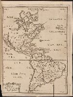
Kort beskrifning om provincien Nya Swerige uti America : som nu foertjden af the Engelske kallas
Image Count:
1
Description:
Preceding p. 1. and Teaching resource: Professor John Mack Faragher, History 141: The American West.
Subject (Geographic):
Canada --Discovery and exploration, South America --Discovery and exploration, United States --Discovery and exploration, and Western Hemisphere --Maps --Early works to 1800
Collection Created:
Stockholm : Tryckt uti Kongl. boktr. hos S. Wankijfs ankia, med egen bekostnad, af J. H. Werner, 1702
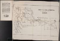
Society for the Propagation of the Faith T. Ireland
Published / Created:
1851 March
Call Number:
Zc13 M6 So3d
Collection Title:
Rapport sur les missions du diocese de Quebec [microform]
Image Count:
1
Subject (Geographic):
Canada --Church history, Missouri, Oregon --Maps, Walla Walla (Wash.) --Maps, Walla Walla Valley (Or. and Wash.), Washington (State), and Westport (Kansas City, Mo.)
Subject (Topic):
Catholic Church --Missions, Indians of North America --Missions --Canada, Missions --Northwest, Pacific, Missions --Oregon, and Missions --Quebec (Province)