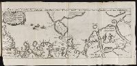
Descriptio ac delineatio geographica detectionis freti, sive, transitus ad occasum supra terras
Image Count:
1
Alternative Title:
Caerte van’t noorderste Russen, Samojeden, ende Tingoesen landt
Description:
Bound in after p. [30]., Description of Siberia by Isaac Abrahamszoon Massa., Map cut and folded irregularly., Map has multiple small ink stains on verso at the top., Printed on recto in lower right corner: D3., and Scale not given.
Subject (Geographic):
Barents Sea --Maps --Early works to 1800
Subject (Name):
Massa, Isaac, 1587-1635
Collection Created:
Amsterodami Ex officina Hesse lij Gerardi. Anno 1613
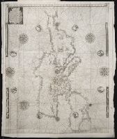
Navtica mediterranea / di Bartolomeo Crescentio Romano ... Nella quale si mostra la fabrica delle
Image Count:
1
Description:
Map bound in at end., Map cut and folded irregularly., Map done on two separate sheets and pasted together in center., Map has several small gray and black smudges on both the recto and verso that appear to be fingerprints left during the engraving process., Map has several small yellow and brown marks, most notably on verso, although one can be seen on recto in lower right section., and Scale [ca. 1:6,500,000].
Subject (Geographic):
Mediterranean Region --Maps --Early works to 1800 and Mediterranean Sea --Navigation --Early works to 1800
Subject (Topic):
Galleys --Early works to 1800, Navigation --Early works to 1800, and Pilot guides --Mediterranean Sea --Early works to 1800
Book labels of Renzo Bonfiglioli and Ch. Fairfax Murray. Bookplate: Ex-libris Guelfo-Sitta., Imprint from colophon., In verse., Large woodcut of Ovid on title page., Printed in double columns., Signatures: A-Y⁸ Z⁴ (Z4v blank)., Title printed in red and black., and Translator from colophon.
Publisher:
Per Iacomo da Leco ad instantia de Nicolo Zoppino & Vince[n]tio di Pollo su compagno,