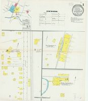
Sanborn fire insurance maps are a rich source of historic data on the urban built environment of North America during the 19th and early 20th centuries. The atlases were created for the purpose of underwriting fire insurance policies, which depended upon accurate and frequently-updated information about construction materials, municipal and transportation infrastructure, industrial and commercial landuse and more. The Yale University Library Map Department scanned its holdings of Sanborn fire insurance maps (consisting primarily of Connecticut towns) in order to make the maps more accessible.
Alternative Title:
Nov. 1901, Canaan, Conn.
Description:
"2 sheets, 5115.", Contains information on population, prevailing winds, water facilities and fire department., Partial cadastral map., and SMLMAPL 766 C16 1901: Sheets disbound. "Triplicate" stamp on both sheets. Library of Congress copyright stamp on title sheet.
Subject (Geographic):
Canaan (Conn.)--Maps
Subject (Topic):
Fire risk assessment--Connecticut--Canaan--Maps and Real property--Connecticut--Canaan--Maps
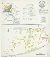
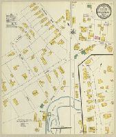
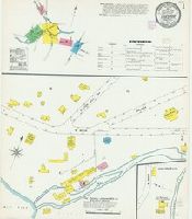
Sanborn fire insurance maps are a rich source of historic data on the urban built environment of North America during the 19th and early 20th centuries. The atlases were created for the purpose of underwriting fire insurance policies, which depended upon accurate and frequently-updated information about construction materials, municipal and transportation infrastructure, industrial and commercial landuse and more. The Yale University Library Map Department scanned its holdings of Sanborn fire insurance maps (consisting primarily of Connecticut towns) in order to make the maps more accessible.
Alternative Title:
May 1909, Canaan, Conn.
Description:
"1436, 3 sheets.", Contains information on population, prevailing winds, water facilities and fire department., Includes index to specials., Partial cadastral map., and SMLMAPL 766 C16 1909: Sheets disbound. Library of Congress copyright stamp on title sheet.
Subject (Geographic):
Canaan (Conn.)--Maps
Subject (Name):
Library of Congress Stamp
Subject (Topic):
Fire risk assessment--Connecticut--Canaan--Maps and Real property--Connecticut--Canaan--Maps
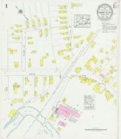
Sanborn fire insurance maps are a rich source of historic data on the urban built environment of North America during the 19th and early 20th centuries. The atlases were created for the purpose of underwriting fire insurance policies, which depended upon accurate and frequently-updated information about construction materials, municipal and transportation infrastructure, industrial and commercial landuse and more. The Yale University Library Map Department scanned its holdings of Sanborn fire insurance maps (consisting primarily of Connecticut towns) in order to make the maps more accessible.
Alternative Title:
Oct. 1923, Canaan, Conn.
Description:
"(1280) (7 sheets).", Contains information on population, prevailing winds, water facilities and fire department., Includes index to streets and specials., Partial cadastral map., and SMLMAPL 766 C16 1923: Sheets disbound. Library of Congress copyright stamp on title sheet.
Subject (Geographic):
Canaan (Conn.)--Maps
Subject (Topic):
Fire risk assessment--Connecticut--Canaan--Maps and Real property--Connecticut--Canaan--Maps
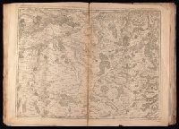
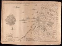
Crépy, Etienne Louis, printer Fricx, Eugène-Henri, d. 1733 Fricx, Eugène-Henri, d. 1733. Cartes des provinces des Pays Bas
Published / Created:
[1743]
Call Number:
1977 Folio 177
Image Count:
2
Resource Type:
Maps, Atlases & Globes
Description:
"No. 7" in lower right corner., Bar scales given in "echelle de deux Lieues et demie com[m]une de France" and "echelle de deux Lieues de Brabant"., From Fricx's Cartes des provinces des Pays Bas, 1744., Relief shown by hachures., Sheet measures 54.7 x 73.6 cm. No. 17 of 34 maps bound together., and Watermark.
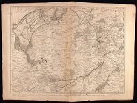
Crépy (Firm) Fricx, Eugène-Henri, d. 1733 Fricx, Eugène-Henri, d. 1733. Cartes des provinces des Pays Bas
Published / Created:
1743
Call Number:
1977 Folio 177
Image Count:
2
Resource Type:
Maps, Atlases & Globes
Description:
"No. 13" in lower right corner, outside of neat line., Bar scales given in "echelle de deux lieues et demie communes de France" and "echelle de deux lieues de Brabant"., From Fricx's Cartes des provinces des Pays Bas, 1744., Prime meridian: Ferro., Relief shown by hachures., Sheet measures 55.3 x 72.3 cm. No. 33 of 34 maps bound together., and Watermark.
Publisher:
Chez Crepy rue S. Jacques a limage S. Pierre,
Subject (Geographic):
Nord-Pas-de-Calais (France)--Maps--Early works to 1800
Crépy, Etienne Louis, printer Fricx, Eugène-Henri, d. 1733 Fricx, Eugène-Henri, d. 1733. Cartes des provinces des Pays Bas
Published / Created:
[1744]
Call Number:
1977 Folio 177
Image Count:
2
Resource Type:
Maps, Atlases & Globes
Description:
"11" in lower right corner., From Fricx's Cartes des provinces des Pays Bas, 1744., Relief shown by hachures., Sheet measures 54.6 x 72.5 cm. No. 19 of 34 maps bound together., and Watermark.
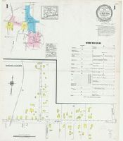
Sanborn fire insurance maps are a rich source of historic data on the urban built environment of North America during the 19th and early 20th centuries. The atlases were created for the purpose of underwriting fire insurance policies, which depended upon accurate and frequently-updated information about construction materials, municipal and transportation infrastructure, industrial and commercial landuse and more. The Yale University Library Map Department scanned its holdings of Sanborn fire insurance maps (consisting primarily of Connecticut towns) in order to make the maps more accessible.
Description:
"(6399).", Contains information on population, prevailing winds, water facilities and fire department., Partial cadastral map., and SMLMAPL 766 C33 1903: "Triplicate" stamp and Library of Congress copyright and Map Division stamps on title sheet.
Subject (Geographic):
Plainfield (Conn.)--Maps
Subject (Name):
Library of Congress Stamp and Library of Congress. Map Division Stamp
Subject (Topic):
Fire risk assessment--Connecticut--Plainfield--Maps and Real property--Connecticut--Plainfield--Maps
Sanborn fire insurance maps are a rich source of historic data on the urban built environment of North America during the 19th and early 20th centuries. The atlases were created for the purpose of underwriting fire insurance policies, which depended upon accurate and frequently-updated information about construction materials, municipal and transportation infrastructure, industrial and commercial landuse and more. The Yale University Library Map Department scanned its holdings of Sanborn fire insurance maps (consisting primarily of Connecticut towns) in order to make the maps more accessible.
Alternative Title:
June 1927, Central Village, Conn.
Description:
"(3170) (2 sheets).", Contains information on population, prevailing winds, water facilities and fire department., Includes index to streets and specials., Partial cadastral map., and SMLMAPL 766 C33 1927: Sheets disbound. Library of Congress copyright stamp on title sheet.
Subject (Geographic):
Plainfield (Conn.)--Maps
Subject (Name):
Library of Congress Stamp
Subject (Topic):
Fire risk assessment--Connecticut--Plainfield--Maps and Real property--Connecticut--Plainfield--Maps
Sanborn fire insurance maps are a rich source of historic data on the urban built environment of North America during the 19th and early 20th centuries. The atlases were created for the purpose of underwriting fire insurance policies, which depended upon accurate and frequently-updated information about construction materials, municipal and transportation infrastructure, industrial and commercial landuse and more. The Yale University Library Map Department scanned its holdings of Sanborn fire insurance maps (consisting primarily of Connecticut towns) in order to make the maps more accessible.
Alternative Title:
Jan. 1925, Cheshire, Conn.
Description:
"(2002) (6 sheets).", Contains information on population, prevailing winds, water facilities and fire department., Includes index to streets and specials., Partial cadastral map., Sheets 2 and 3 at scale 1:600; sheets 1, 4, 5 and 6 at scale 1:1,200., and SMLMAPL 766 C422 1925: Sheets disbound. Library of Congress copyright stamp on title sheet.
Subject (Geographic):
Cheshire (Conn.)--Maps
Subject (Name):
Library of Congress Stamp
Subject (Topic):
Fire risk assessment--Connecticut--Cheshire--Maps and Real property--Connecticut--Cheshire--Maps
Sanborn fire insurance maps are a rich source of historic data on the urban built environment of North America during the 19th and early 20th centuries. The atlases were created for the purpose of underwriting fire insurance policies, which depended upon accurate and frequently-updated information about construction materials, municipal and transportation infrastructure, industrial and commercial landuse and more. The Yale University Library Map Department scanned its holdings of Sanborn fire insurance maps (consisting primarily of Connecticut towns) in order to make the maps more accessible.
Alternative Title:
July 1908, Chester, Conn.
Description:
"4 sheets, #510.", Contains information on population, prevailing winds, water facilities and fire department., Includes index of streets and specials., Partial cadastral map., and SMLMAPL 766 C426 1908: Sheets disbound. Library of Congress copyright and Map Division stamps on title sheet.
Subject (Geographic):
Chester (Conn. : Town)--Maps
Subject (Name):
Library of Congress Stamp and Library of Congress. Map Division Stamp
Subject (Topic):
Fire risk assessment--Connecticut--Chester (Town)--Maps and Real property--Connecticut--Chester (Town)--Maps