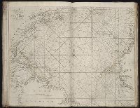
The English pilot: describing the West-India navigation, from Hudson's-Bay to the river Amazones
Image Count:
1
Description:
Imperfect: mutilated with some loss of image.
Subject (Geographic):
Africa, West --Maps --Early works to 1800, Atlantic Ocean --Maps --Early works to 1800, New England --Maps --Early works to 1800, Newfoundland and Labrador --Maps --Early works to 1800, Portugal --Maps --Early works to 1800, South America --Maps --Early works to 1800, and West Indies --Maps --Early works to 1800
Subject (Topic):
Navigation --Early works to 1800, Pilot guides --Atlantic Coast (U.S.) --Early works to 1800, and Pilot guides --Caribbean Area --Early works to 1800
The English pilot: describing the West-India navigation, from Hudson's-Bay to the river Amazones
Image Count:
1
Description:
Map trimmed irregularly.
Subject (Geographic):
Africa, West --Maps --Early works to 1800, Atlantic Ocean --Maps --Early works to 1800, New England --Maps --Early works to 1800, Newfoundland and Labrador --Maps --Early works to 1800, Portugal --Maps --Early works to 1800, South America --Maps --Early works to 1800, and West Indies --Maps --Early works to 1800
Subject (Topic):
Navigation --Early works to 1800, Pilot guides --Atlantic Coast (U.S.) --Early works to 1800, and Pilot guides --Caribbean Area --Early works to 1800
Collection Created:
London : Printed for Thomas Page, William and Fisher Mount, in Postern-Row on Tower-hill, MDCCXXV [1725]
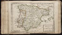
Twenty four new and accurate maps of the several parts of Europe ... : all (except the last) new
Image Count:
1
Description:
In pencil on verso: 18.
Subject (Geographic):
Portugal --Maps --Early works to 1800 and Spain --Maps --Early works to 1800
Subject (Name):
Barker, B. (Benjamin), d. 1764, bookseller, Clements, Henry, d. 1719, bookseller, King, Charles, d. 1735, bookseller, Nicholson, John, d. ca. 1717, bookseller, Parker, Richard, fl. 1692-1725, bookseller, and Tooke, Benjamin, d. 1716, bookseller
Subject (Topic):
Atlases --Early works to 1800
Collection Created:
[London] : Sold by J. Nicholson at the King’s-Arms in Little Britain, Benj. Barker and Charles King ..., Benj. Tooke ..., Hen. Clements ..., R. Parker and Ralph Smith under the Royal-Exchange ..., [1715?]
Also appeared in Kitchin's General atlas describing the whole universe. London : Printed Robert Sayer and J. Bennet, 1773; and General atlas describing the whole universe. London : Printed and sold for R. Sayer and J. Bennet, 1780., Ferro meridian., Ms. notes on, and newspaper clipping pasted to, verso. No. 14 of 43 maps bound together in composite atlas., Relief shown pictorially., Scale [1:2,300,000]., and Shows boundaries, rivers and settlements.
Publisher:
Printed for Rob. Sayer
Subject (Geographic):
Iberian Peninsula, Portugal --Maps --Early works to 1800, and Spain --Maps --Early works to 1800