Skip to search
Skip to main content
Skip to first result
Search
You Searched For
Extent of Digitization
Unspecified
Resource Type
Maps, Atlases & Globes
New Search
Search Results
Creator:
Published / Created:
1931
Call Number:
766 N472 1931
Image Count:
11
Resource Type:
Maps, Atlases & Globes
Found in:
Beinecke Rare Book and Manuscript Library > New Milford, Litchfield County, Connecticut.
Creator:
Published / Created:
[1729?]
Call Number:
1973 +32
Image Count:
13
Resource Type:
Maps, Atlases & Globes
Found in:
Beinecke Rare Book and Manuscript Library > La galerie agreable du monde, ouíÛ l'on voit en un grand nombre de cartes tres-exactes et de belles tailles-douces, les principaux empires, roiíöaumes, republiques, provinces, villes, bourgs et forteresses ... dans les quatre parties de l'univers. Diviseí
Creator:
Published / Created:
1926
Call Number:
766 M31 1926
Image Count:
36
Resource Type:
Maps, Atlases & Globes
Found in:
Beinecke Rare Book and Manuscript Library > Insurance maps of Manchester, including part of Highland Park and Manchester Green, Hartford Co., Connecticut.
Creator:
Published / Created:
1925
Call Number:
766 M59 1925
Image Count:
31
Resource Type:
Maps, Atlases & Globes
Found in:
Beinecke Rare Book and Manuscript Library > Insurance maps of Milford, New Haven County, Connecticut, including Woodmont, Merwin's Point, Bay View, Fort Trumbull Beach, Silver Sands, Seaside, Myrtle Beach, Meadows End, Walnut Beach, Wildmere Beach, Laurel Beach, Cedar Beach, Devon and Rivercliff.
Creator:
Published / Created:
July 1941
Call Number:
766 M54 1901
Image Count:
5
Resource Type:
Maps, Atlases & Globes
Found in:
Beinecke Rare Book and Manuscript Library > Insurance maps of Meriden, New Haven, Connecticut., Insurance maps of Meriden, New Haven, Connecticut: [New sheets and correction slips].
Published / Created:
1918
Call Number:
RG 14
Collection Title:
Archives of the Trustees of Lingnan University
Container / Volume:
Box 51 | Folder 573
Image Count:
1
Resource Type:
Maps, Atlases & Globes
Found in:
Yale Divinity Library > Architect's Map of Campus
Published / Created:
approximately 1935
Image Count:
1
Resource Type:
Maps, Atlases & Globes
Found in:
Medical Historical Library, Cushing/Whitney Medical Library > Cushing/Whitney Medical Library sketch
Creator:
Published / Created:
1932
Image Count:
1
Resource Type:
Maps, Atlases & Globes
Found in:
Medical Historical Library, Cushing/Whitney Medical Library > "A View of Human Welfare Group"
Published / Created:
undated
Call Number:
WA MSS S-2962
Collection Title:
Northern Pacific Railway Company maps and drawings
Container / Volume:
Box 1 | Map 11
Image Count:
1
Resource Type:
Maps, Atlases & Globes
Found in:
Beinecke Rare Book and Manuscript Library > (IDAHO & WASHINGTON) [Anon.] [Untitled map of northwestern Idaho and northeastern Washington].
Creator:
Published / Created:
1890
Call Number:
WA MSS S-2962
Collection Title:
Northern Pacific Railway Company maps and drawings
Container / Volume:
Box 1 | Map 10
Image Count:
2
Resource Type:
Maps, Atlases & Globes
Found in:
Beinecke Rare Book and Manuscript Library > (IDAHO) Kendrick, J. W., Surveyor. Map Showing Definite Location of the Spokane & Palouse Ry. (Lewiston Extension). From Julietta to Lewiston Idaho Territory. Distance 24-1/lO Miles. Drawn by J. M. Gibboney. Assistant Engineer's Office, Tacoma, Washington. Scale 1 in.=2000 ft.
Creator:
Published / Created:
1891 April 6
Call Number:
WA MSS S-2962
Collection Title:
Northern Pacific Railway Company maps and drawings
Container / Volume:
Box 1 | Map 34
Image Count:
1
Resource Type:
Maps, Atlases & Globes
Found in:
Beinecke Rare Book and Manuscript Library > (MONTANA) Bischoff, A. Map of North- West part of Montana...Great Northern Line St. Paul, Minneapolis & Manitoba Ry. Pacific Extension. Elbridge H. Beckler, Chief Engineer. Helena, Mont. Scale 1 in.= 2 miles.
Published / Created:
1886
Call Number:
WA MSS S-2962
Collection Title:
Northern Pacific Railway Company maps and drawings
Container / Volume:
Box 1 | Map 31
Image Count:
1
Resource Type:
Maps, Atlases & Globes
Found in:
Beinecke Rare Book and Manuscript Library > (MONTANA) [Anon.] Map of a Portion of Montana Territory.
Creator:
Published / Created:
1887 August
Call Number:
WA MSS S-2962
Collection Title:
Northern Pacific Railway Company maps and drawings
Container / Volume:
Box 1 | Map 33
Image Count:
2
Resource Type:
Maps, Atlases & Globes
Found in:
Beinecke Rare Book and Manuscript Library > (MONTANA) Roberts, E. J. Montana Extension. The Saint Paul, Minneapolis and Manitoba Ry. Co. Scale 12 miles to 1 inch.
Published / Created:
1891 September 10
Call Number:
WA MSS S-2962
Collection Title:
Northern Pacific Railway Company maps and drawings
Container / Volume:
Box 1 | Map 40
Image Count:
1
Resource Type:
Maps, Atlases & Globes
Found in:
Beinecke Rare Book and Manuscript Library > (WASHINGTON) [Anon.] Sketch of Country North of Spokane Wash. Helena Mont.
Published / Created:
undated
Call Number:
WA MSS S-2962
Collection Title:
Northern Pacific Railway Company maps and drawings
Container / Volume:
Box 1 | Map 36
Image Count:
1
Resource Type:
Maps, Atlases & Globes
Found in:
Beinecke Rare Book and Manuscript Library > (MONTANA) [Anon.] [Untitled map of a part of north central Montana.]
Published / Created:
undated
Call Number:
WA MSS S-2962
Collection Title:
Northern Pacific Railway Company maps and drawings
Container / Volume:
3 (Roll) | Map 24
Image Count:
1
Resource Type:
Maps, Atlases & Globes
Found in:
Beinecke Rare Book and Manuscript Library > (MONTANA & IDAHO) [Anon.] [Untitled map of far northwestern Montana and a part of the Idaho panhandle.]
Call Number:
1977 +392
Collection Title:
A survey of the cities of London and Westminster : containing the original, antiquity, increase
Image Count:
1
Resource Type:
Maps, Atlases & Globes
Found in:
Beinecke Rare Book and Manuscript Library > Spittle Fields and places adjacent taken from the last survey with corrections
Creator:
Published / Created:
1859]
Call Number:
BrSides Zc49 859cL
Image Count:
1
Resource Type:
Maps, Atlases & Globes
Found in:
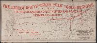
Beinecke Rare Book and Manuscript Library > For Pike's Peak and the gold mines, via Cleveland & Toledo Rail Road. A direct and all rail road line to St. Joseph, Kansas T
Creator:
Published / Created:
[1859]
Call Number:
BrSides Zc49 859to
Image Count:
1
Resource Type:
Maps, Atlases & Globes
Found in:
Beinecke Rare Book and Manuscript Library > The direct route to Pike's peak and the gold regions via the Toledo Wabash & Great Western Rail Road Line and the Hannibal & St. Joseph R.R
Creator:
Published / Created:
1859
Call Number:
Zc39 859gu
Collection Title:
New map and hand-book of Kansas & the gold mines : containing descriptions and statistics of the
Image Count:
1
Resource Type:
Maps, Atlases & Globes
Found in:
Beinecke Rare Book and Manuscript Library > Gunn's new map of Kansas and the gold mines
Creator:
Call Number:
Zc49 859pa
Collection Title:
Pacific Railroad of Missouri, the old established and most reliable route to Kansas, Nebraska, and
Image Count:
1
Resource Type:
Maps, Atlases & Globes
Found in:
Beinecke Rare Book and Manuscript Library > Map of the Pacific Railroad, with its connections, and the central route to the gold region
Creator:
Published / Created:
[1860?]
Call Number:
Zc49 860gs
Collection Title:
Traveller's companion and guide westward. Great Western & Mich'n Central Railway line and
Image Count:
1
Resource Type:
Maps, Atlases & Globes
Found in:
Beinecke Rare Book and Manuscript Library > Map of the Great Western railway, and its connecting railroad lines
Creator:
Published / Created:
1859
Call Number:
BrSides Zc49 859ma
Image Count:
1
Resource Type:
Maps, Atlases & Globes
Found in:
Beinecke Rare Book and Manuscript Library > Map of the United States west of the Mississippi showing the routes to Pike's Peak, overland mail route to California and Pacific rail road surveys. To which are added the new state & territorial boundaires, the principal mail & rail road routes with all
Creator:
Published / Created:
1859
Call Number:
Zc49 859oL
Collection Title:
Guide to the new gold region of western Kansas and Nebraska, with table of distances and an
Image Count:
1
Resource Type:
Maps, Atlases & Globes
Found in:
Beinecke Rare Book and Manuscript Library > Map of routes to the gold region of western Kansas
Published / Created:
[1859?]
Call Number:
Zc49 859oh
Collection Title:
Pike's Peak : great through line between the East and West, via Cincinnati and St. Louis by the
Image Count:
1
Resource Type:
Maps, Atlases & Globes
Found in:
Beinecke Rare Book and Manuscript Library > Map of the Mississippi railroad with its western connections and the route to the gold regions
Creator:
Published / Created:
1859
Call Number:
Zc49 859iL
Collection Title:
The illustrated miners' hand-book and guide to Pike's Peak, with a new and reliable map, shiowing
Image Count:
1
Resource Type:
Maps, Atlases & Globes
Found in:
Beinecke Rare Book and Manuscript Library > New map of the Pikes Peak gold region. Showing all the routes from the Mississippi & Missouri Rivers, and the outfitting points
Published / Created:
March 1, 1809
Call Number:
1978 226
Collection Title:
A new royal atlas, illustrative of the various divisions which comprise the surface of the globe...
Image Count:
1
Resource Type:
Maps, Atlases & Globes
Found in:
Beinecke Rare Book and Manuscript Library > Asia. Engraved for Evans's Geographical Grammar
Published / Created:
March 1, 1809
Call Number:
1978 226
Collection Title:
A new royal atlas, illustrative of the various divisions which comprise the surface of the globe...
Image Count:
1
Resource Type:
Maps, Atlases & Globes
Found in:
Beinecke Rare Book and Manuscript Library > Hindoostan
Published / Created:
1808
Call Number:
1978 Folio 34
Collection Title:
Smith's New general atlas, containing distinct maps of all the principal empires, kingdoms
Image Count:
1
Resource Type:
Maps, Atlases & Globes
Found in:
Beinecke Rare Book and Manuscript Library > Eastern Hemisphere
Published / Created:
January 6, 1808
Call Number:
1978 Folio 34
Collection Title:
Smith's New general atlas, containing distinct maps of all the principal empires, kingdoms
Image Count:
1
Resource Type:
Maps, Atlases & Globes
Found in:
Beinecke Rare Book and Manuscript Library > Hindoostan
Creator:
Published / Created:
1851
Call Number:
Ne92 A18 D64 1851
Collection Title:
Disturnell's American and European railway and steamship guide; giving the arrangements on all the
Image Count:
1
Resource Type:
Maps, Atlases & Globes
Found in:
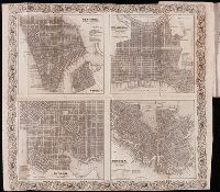
Beinecke Rare Book and Manuscript Library > Map of New York, Philadelphia, Baltimore and Boston
Published / Created:
1722
Call Number:
Zc52 +722pe
Collection Title:
Derrotero de la expedicion en la provincia de los Texas, nuevo reyno de Philipinas, que de orden
Image Count:
2
Resource Type:
Maps, Atlases & Globes
Found in:
Beinecke Rare Book and Manuscript Library > Plan del Presidio dens de los Dolores
Creator:
Published / Created:
1755
Call Number:
391 +1755h
Collection Title:
Geographical, historical, political, philosophical and mechanical essays : the first, containing an
Image Count:
1
Resource Type:
Maps, Atlases & Globes
Found in:
Beinecke Rare Book and Manuscript Library > A general map of the middle British colonies in America
Creator:
Published / Created:
1758
Call Number:
1977 Folio 177
Image Count:
3
Resource Type:
Maps, Atlases & Globes
Found in:
Beinecke Rare Book and Manuscript Library > The seat of war on the coast of France : being a new chart of the coasts of Holland, Flanders, France, Spain & Portugal, with the adjacent Islands, part of Barbary, England and Ireland / drawn from the latest surveys, and regulated by astronomical observa
Creator:
Published / Created:
1796
Call Number:
1977 Folio 177
Image Count:
2
Resource Type:
Maps, Atlases & Globes
Found in:
Beinecke Rare Book and Manuscript Library > Connecticut / entworfen von D.F. Sotzmann ; P. Schmidt, sculp.
Creator:
Published / Created:
1796
Call Number:
1977 Folio 177
Image Count:
2
Resource Type:
Maps, Atlases & Globes
Found in:
Beinecke Rare Book and Manuscript Library > New Hampshire / entworfen von D.F. Sotzmann ; P. Schmidt, sculpsit.
Creator:
Published / Created:
1798
Call Number:
1977 Folio 177
Image Count:
2
Resource Type:
Maps, Atlases & Globes
Found in:
Beinecke Rare Book and Manuscript Library > Maine / entworfen von D.F. Sotzmann ; Sander, sc.
Creator:
Published / Created:
1799
Call Number:
1977 Folio 177
Image Count:
2
Resource Type:
Maps, Atlases & Globes
Found in:
Beinecke Rare Book and Manuscript Library > New York / entworfen von D.F. Sotzmann.
Creator:
Published / Created:
1797
Call Number:
1977 Folio 177
Image Count:
2
Resource Type:
Maps, Atlases & Globes
Found in:
Beinecke Rare Book and Manuscript Library > Rhode Island / entworfen von D.F. Sotzmann ; gestochen von H. Kliewer.
Creator:
Published / Created:
1797
Call Number:
1977 Folio 177
Image Count:
2
Resource Type:
Maps, Atlases & Globes
Found in:
Beinecke Rare Book and Manuscript Library > Maryland und Delaware / entworfen von D.F. Sotzmann.
Creator:
Published / Created:
1797
Call Number:
1977 Folio 177
Image Count:
2
Resource Type:
Maps, Atlases & Globes
Found in:
Beinecke Rare Book and Manuscript Library > New Jersey / entworfen von D.F. Sotzmann.
Creator:
Published / Created:
1796
Call Number:
1977 Folio 177
Image Count:
2
Resource Type:
Maps, Atlases & Globes
Found in:
Beinecke Rare Book and Manuscript Library > Vermont / entworfen von D.F. Sotzmann ; P. Schmidt sc. zu Berlin.
Creator:
Published / Created:
1797
Call Number:
1977 Folio 177
Image Count:
2
Resource Type:
Maps, Atlases & Globes
Found in:
Beinecke Rare Book and Manuscript Library > Pennsylvania / entworfen von D.F. Sotzman[n].
Creator:
Published / Created:
1757
Call Number:
1977 Folio 177
Image Count:
3
Resource Type:
Maps, Atlases & Globes
Found in:
Beinecke Rare Book and Manuscript Library > Circuli supe. Saxoniae pars meridionalis sive Ducatus, Electoratus et Principatus Ducum Saxoniae / ex Zolmannianis et Zuíörnerianis subsidijs designata et edita per Homannianos Heredes.
Creator:
Published / Created:
1787
Call Number:
1977 Folio 177
Image Count:
2
Resource Type:
Maps, Atlases & Globes
Found in:
Beinecke Rare Book and Manuscript Library > A map of the country between Albemarle Sound, and Lake Erie [cartographic material] : comprehending the whole of Virginia, Maryland, Delaware and Pensylvania, with parts of several other of the United States of America / engraved by S.J. Neele.
Creator:
Published / Created:
1795
Call Number:
1977 Folio 177
Image Count:
2
Resource Type:
Maps, Atlases & Globes
Found in:
Beinecke Rare Book and Manuscript Library > A map of the district of Maine : drawn from the latest surveys and other best authorities / by Osgood Carleton ; Doolittle, sc., Newhaven.
Creator:
Published / Created:
1785
Call Number:
1977 Folio 177
Image Count:
2
Resource Type:
Maps, Atlases & Globes
Found in:
Beinecke Rare Book and Manuscript Library > A general chart exhibiting the discoveries made by Captn. James Cook in this and his two preceeding voyages with the tracks of the ships under his command / by Lieutt. Roberts of His Majesty's Royal Navy ; Jn. Lodge sc.
Creator:
Published / Created:
[1768]
Call Number:
1977 Folio 177
Image Count:
2
Resource Type:
Maps, Atlases & Globes
Found in:
Beinecke Rare Book and Manuscript Library > Martinico, one of the Caribbee Islands in the West Indies subject to the French / [cartographic material] / according to the observations of Mr. Houel engineer ; by Thos. Jefferys, geographer to His Royal Highness the Prince.
Creator:
Published / Created:
Oct. 28, 1756.
Call Number:
1977 Folio 177
Image Count:
3
Resource Type:
Maps, Atlases & Globes
Found in:
Beinecke Rare Book and Manuscript Library > The routs of the Prussian Armies into Bohemia [cartographic material] : with the post roads & distances from the original map publish'd at Berlin / by Thos. Jefferys ...
Creator:
Published / Created:
Jany. 1st, 1795.
Call Number:
1977 Folio 177
Image Count:
2
Resource Type:
Maps, Atlases & Globes
Found in:
Beinecke Rare Book and Manuscript Library > A map of China : with the surrounding states, correctly copied from Monsr. d'Anville : engraved for Monsr. de Paun's Philosophical dissertations on the Egyptians & Chinese.
Branch:v1.60.98 ,Deployed:2024-04-24T10:14:30-04:00