Anville, Jean Baptiste Bourguignon d', 1697-1782 Compagnie des Indes Jefferys, Thomas, d. 1771, creator Kitchin, Thomas, d. 1784 Robert Laurie and James Whittle Sayer, Robert, 1725-1794
Published / Created:
1789 January 1
Call Number:
1982 Folio 10
Image Count:
1
Description:
Also appeared in Kitchin's General atlas describing the whole universe. London : Printed for Robert Sayer, [1780]., Has illustrated cartouche and includes text., No. 36 of 43 maps bound together in composite atlas., Norwich, O.I. Norwich's maps of Africa., Prime meridians: Ferro and London., Relief shown pictorially; depths by soundings., Scale [ca. 1:1,850,000]., and This map is copied from an original drawn by Monsr. D'Anville at the expense of the French East India Company, & published at Paris. The country thorough [sic] which the R. Senegal runs has been improved & corrected from a large & curious survey of that river found in the Fort of Senegal.
Africa distinguished into its principall parts viz. Barbary, Biledulgerid, Egypt, Zaara or the Desart, the Country of the Negroes, Guinea, Nubia, Abissinea, Zanguebar, Congo, Monomotapa, Caffrares, the Islands of the Canaries, Cape Verd, St. Thomas, Madagascar or St. Lawrence in which are observed the empires, monarchies, kingdomes, states and peoples, which at present inhabite Africa
Description:
Ferro meridian., No. 56 of 69 maps bound together in composite atlas., Relief shown pictorially., Scale [ca 1:34 000 000]., and To the most serene and most sacred majesty of Charles II, by the grace of God, king of Great Brittain, France, and Ireland, this map of Africa is humbly dedicated and presented by your majesties loyal subject and servant, William Berry.
Publisher:
Sold by William Berry at the sign of the globe between Charing Cross and White-Hall
Delarochette, L. (Louis), 1731-1802, creator Faden, William, 1749-1836
Published / Created:
1782 March 20
Call Number:
1982 Folio 10
Image Count:
1
Description:
No. 37 of 43 maps bound together in composite atlas., Place names in Dutch; pictorial relief. "The red line describes the route of the British Army from its landing at Simons Baay to Cape Town.", and Scale [ca. 1:528 000].
Also appeared in Kitchin's General atlas describing the whole universe. London : Printed for Robert Sayer, [1780]., By S. Boulton ; and also a summary description relative to the trade and natural produce, manners and customs of the African continent and islands., Insets: A particular chart of the Gold Cost. -- Azores or Western Islands., No. 35 of 43 maps bound together in composite atlas., Scale [ca. 1:8,500,000]., Sheets pasted together to create 1 map on 2 sheets., and With descriptive text.
Appears in Blaeu's Atlas major., Bar scale given in milliaria Germanica., Ferro meridian., No. 61 of 69 maps bound together in composite atlas., Relief shown pictorially., and Scale [ca. 1:8 500 000].
Appears in Blaeu's Atlas major., Bar scale given in milliaria Germanica communia., Ferro meridian., Includes illustration of animals and ornamental cartouche., No. 60 of 69 maps bound together in composite atlas., Relief shown pictorially., and Scale [ca. 1:12 000 000].
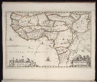
Ferro meridian., From Bleau's Atlas major (German ed.). Zu Amsterdam : Bey Johannem Blaeu, [ca. 1670]., No. 58 of 69 maps bound together in composite atlas., Relief shown pictorially., and Scale [ca. 1:4 000 000].
Bar scale given in milliaria Germanica communia., Covers west Africa from Tropic of Cancer southward., Ferro meridian., Map includes decorative title and scale statement cartouches with native figures and local fauna. Map interior displays three elephants., No. 59 of 69 maps bound together in composite atlas., Place names in Latin and Portuguese., Relief shown pictorially., and Scale [ca. 1:12 000 000].