Skip to search
Skip to main content
Skip to first result
Search
You Searched For
Format
cartographic
Genre
Atlases
Language
English
Search Results
Published / Created:
1850
Call Number:
1976 Folio 96
Collection Title:
A new universal atlas containing maps of the various empires, kingdoms, states and republics of the
Image Count:
1
Resource Type:
Maps, Atlases & Globes
Publisher:
Thomas, Cowperthwait & Co
Subject (Geographic):
Connecticut
Collection Created:
Philadelphia, Cowperthwait, DeSilver & Butler, 1854, c1850
Found in:
Beinecke Rare Book and Manuscript Library > 10. Map of Connecticut
Creator:
Published / Created:
[1839?]
Call Number:
G1200 T34 1839 (LC)
Image Count:
4
Resource Type:
Maps, Atlases & Globes
Description:
Many maps dated 1839, other maps undated.
Publisher:
H.S. Tanner,
Subject (Geographic):
North America--Maps, South America--Maps, and United States--Maps
Found in:
Beinecke Rare Book and Manuscript Library > A new American atlas [cartographic material] : containing maps of the several states of the North American union ... / by Henry S. Tanner.
Published / Created:
1833
Call Number:
2002 Folio 97
Collection Title:
Tanner’s universal atlas : subscription price $1.00 a number, seperate [sic] numbers $1.50 each
Image Count:
1
Resource Type:
Maps, Atlases & Globes
Alternative Title:
II.-Map of the state of Maine
Description:
Plate identified as "II" on atlas cover and "5" on map.
Subject (Geographic):
Maine
Collection Created:
Philadelphia : Published by the author, 1833-1836
Found in:
Beinecke Rare Book and Manuscript Library > A new map of Maine
Published / Created:
1850
Call Number:
1975 Folio 26
Collection Title:
A new universal atlas containing maps of the various empires, kingdoms, states and republics of the
Image Count:
1
Resource Type:
Maps, Atlases & Globes
Subject (Name):
P.S. Duval & Son
Collection Created:
Philadelphia, Thomas, Cowperthwait & Co., No. 253 Market street, 1852
Found in:
Beinecke Rare Book and Manuscript Library > A new map of Maine
Published / Created:
1846
Call Number:
1976 Folio 93
Collection Title:
Mitchell’s universal atlas
Image Count:
1
Resource Type:
Maps, Atlases & Globes
Subject (Geographic):
Maine
Collection Created:
Philadelphia, S.A. Mitchell, 1847, c1844
Found in:
Beinecke Rare Book and Manuscript Library > A new map of Maine
Published / Created:
1833
Call Number:
1976 Folio 98
Collection Title:
A new universal atlas, containing maps of the various empires, kingdoms, states and republics of
Image Count:
1
Resource Type:
Maps, Atlases & Globes
Subject (Geographic):
Maine
Collection Created:
Philadelphia, Published by the author, 1836
Found in:
Beinecke Rare Book and Manuscript Library > A new map of Maine
Published / Created:
1850
Call Number:
1976 Folio 96
Collection Title:
A new universal atlas containing maps of the various empires, kingdoms, states and republics of the
Image Count:
1
Resource Type:
Maps, Atlases & Globes
Publisher:
Thomas, Cowperthwait & Co
Subject (Geographic):
Maine
Collection Created:
Philadelphia, Cowperthwait, DeSilver & Butler, 1854, c1850
Found in:
Beinecke Rare Book and Manuscript Library > A new map of Maine
Call Number:
1976 Folio 94
Collection Title:
A new universal atlas containing maps of the various empires, kingdoms, states and republics of the
Image Count:
1
Resource Type:
Maps, Atlases & Globes
Subject (Geographic):
Maine
Collection Created:
Philadelphia, S.A. Mitchell, 1849
Found in:
Beinecke Rare Book and Manuscript Library > A new map of Maine
Creator:
Published / Created:
1890
Call Number:
766 An81 1890
Image Count:
13
Resource Type:
Maps, Atlases & Globes
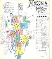
Abstract:
Sanborn fire insurance maps are a rich source of historic data on the urban built environment of North America during the 19th and early 20th centuries. The atlases were created for the purpose of underwriting fire insurance policies, which depended u...
Alternative Title:
Ansonia, Connecticut and Dec. 1890, Ansonia, Conn.
Description:
"13 sheets (4176)."
Subject (Geographic):
Ansonia (Conn.)--Maps
Subject (Name):
Library of Congress Stamp
Subject (Topic):
Fire risk assessment--Connecticut--Ansonia--Maps and Real property--Connecticut--Ansonia--Maps
Found in:
Beinecke Rare Book and Manuscript Library > Ansonia, New Haven Co., Connecticut.
Creator:
Published / Created:
1924
Call Number:
766 An81 1924
Image Count:
39
Resource Type:
Maps, Atlases & Globes
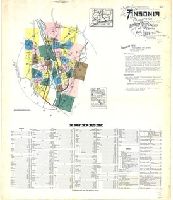
Abstract:
Sanborn fire insurance maps are a rich source of historic data on the urban built environment of North America during the 19th and early 20th centuries. The atlases were created for the purpose of underwriting fire insurance policies, which depended u...
Alternative Title:
Ansonia, Connecticut and Mar. 1924, Ansonia, Conn.
Description:
"39 sheets (1516)."
Subject (Geographic):
Ansonia (Conn.)--Maps
Subject (Topic):
Fire risk assessment--Connecticut--Ansonia--Maps and Real property--Connecticut--Ansonia--Maps
Found in:
Beinecke Rare Book and Manuscript Library > Ansonia, New Haven Co., Connecticut.