Skip to search
Skip to main content
Skip to first result
Search
You Searched For
america maps
Format
cartographic
Genre
California as an island--169-
Genre
Maps
New Search
Search Results
Creator:
Published / Created:
169-?]
Call Number:
70 1670A
Container / Volume:
BRBL_00354
Image Count:
1
Resource Type:
Maps , Atlases & Globes
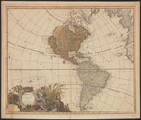
Description:
Shows North and South America
Publisher:
s.n.,
Subject (Geographic):
America --Maps --Early works to 1800
Subject (Name):
Valck, Leonard, 1675-1746
Found in:
Beinecke Rare Book and Manuscript Library > America aurea pars altera mundi / auctoribus Gerardo et Leonardo Valk.
Creator:
Published / Created:
169-?]
Call Number:
70 1670
Container / Volume:
BRBL_00685
Image Count:
1
Resource Type:
Maps , Atlases & Globes
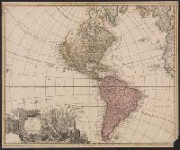
Description:
Shows North and South America
Publisher:
s.n.,
Subject (Geographic):
America --Maps --Early works to 1800
Subject (Name):
Valck, Leonard, 1675-1746
Found in:
Beinecke Rare Book and Manuscript Library > America aurea pars altera mundi / auctoribus Gerardo et Leonardo Valk.
Creator:
Published / Created:
[169-?]
Call Number:
70 169X
Container / Volume:
BRBL_00354
Image Count:
1
Resource Type:
Maps , Atlases & Globes
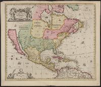
Description:
Hand col. Sheet measures 51 x 60 cm. Stamp on verso: Horace Brown 1900S., Includes ill. and text., Relief shown pictorially., Shows California as an island and boundaries as dotted lines., and State 3, issued ca. 1694, according to Burden.
Publisher:
Penes Gerardum Valk et Petrum Schenk,
Subject (Geographic):
North America --Maps --Early works to
Subject (Name):
Schenk, Peter, 1660-1718 or 1719
Found in:
Beinecke Rare Book and Manuscript Library > America Septentrionalis.
Creator:
Published / Created:
169-?]
Call Number:
70 169XB
Container / Volume:
BRBL_00354
Image Count:
1
Resource Type:
Maps , Atlases & Globes
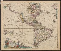
Alternative Title:
Americae septentrionalis et meridionalis tabula
Description:
Includes ill., Relief shown pictorially., Shows California as an island and Terra Esonis, Yedso, and Iaponae Ins. to northwest of Calif., and State 1, [1697?], according to McLaughlin (shows cities on Terra Esonis).
Publisher:
[J. Danckerts?,
Subject (Geographic):
America --Maps --Early works to 1800
Found in:
Beinecke Rare Book and Manuscript Library > Recentissima novi orbis, sive, Americae Septentrionalis et Meridionalis tabula / per I. Danckerts, Amst: cum privilegio.
Branch:v1.61.6 ,Deployed:2024-06-12T09:55:36-04:00