Search
You Searched For
Search Results
- Published / Created:
- 1850
- Call Number:
- 1976 Folio 96
- Collection Title:
- A new universal atlas containing maps of the various empires, kingdoms, states and republics of the
- Image Count:
- 1
- Resource Type:
- Maps, Atlases & Globes
- Publisher:
- Thomas, Cowperthwait & Co
- Subject (Geographic):
- Connecticut
- Collection Created:
- Philadelphia, Cowperthwait, DeSilver & Butler, 1854, c1850
- Found in:
- Beinecke Rare Book and Manuscript Library > 10. Map of Connecticut
- Published / Created:
- 1833
- Call Number:
- 2002 Folio 97
- Collection Title:
- Tanner’s universal atlas : subscription price $1.00 a number, seperate [sic] numbers $1.50 each
- Image Count:
- 1
- Resource Type:
- Maps, Atlases & Globes
- Alternative Title:
- II.-Map of the state of Maine
- Description:
- Plate identified as "II" on atlas cover and "5" on map. and Verso blank.
- Subject (Geographic):
- Maine
- Collection Created:
- Philadelphia : Published by the author, 1833-1836
- Found in:
- Beinecke Rare Book and Manuscript Library > A new map of Maine
- Published / Created:
- 1833
- Call Number:
- 1976 Folio 98
- Collection Title:
- A new universal atlas, containing maps of the various empires, kingdoms, states and republics of
- Image Count:
- 1
- Resource Type:
- Maps, Atlases & Globes
- Subject (Geographic):
- Maine
- Collection Created:
- Philadelphia, Published by the author, 1836
- Found in:
- Beinecke Rare Book and Manuscript Library > A new map of Maine
- Published / Created:
- 1850
- Call Number:
- 1976 Folio 96
- Collection Title:
- A new universal atlas containing maps of the various empires, kingdoms, states and republics of the
- Image Count:
- 1
- Resource Type:
- Maps, Atlases & Globes
- Publisher:
- Thomas, Cowperthwait & Co
- Subject (Geographic):
- Maine
- Collection Created:
- Philadelphia, Cowperthwait, DeSilver & Butler, 1854, c1850
- Found in:
- Beinecke Rare Book and Manuscript Library > A new map of Maine
- Call Number:
- 1976 Folio 94
- Collection Title:
- A new universal atlas containing maps of the various empires, kingdoms, states and republics of the
- Image Count:
- 1
- Resource Type:
- Maps, Atlases & Globes
- Subject (Geographic):
- Maine
- Collection Created:
- Philadelphia, S.A. Mitchell, 1849
- Found in:
- Beinecke Rare Book and Manuscript Library > A new map of Maine
- Creator:
- Braun, Georg, 1540 or 1-1622
Hierat, Anton, fl.1597-1627
Hogenberg, Abraham, fl. 1608-1653
Hogenberg, Franz, d. 1590?
- Published / Created:
- 1572]-1618
- Call Number:
- 1975 Folio 41
- Image Count:
- 1
- Resource Type:
- Maps, Atlases & Globes
- Alternative Title:
- Civitates orbis terrarum ...
- Publisher:
- [Coloniae Agrippinae,
- Subject (Geographic):
- Rome--Antiquities--Early works to 1800 and Rome--Antiquities--Maps
- Subject (Topic):
- Cities and towns, Medieval and Maps, Pictorial -- (LC)
- Found in:
- Beinecke Rare Book and Manuscript Library > Civitates orbis terrarvm ...

- Creator:
- Astrophilus, fl. 1742
Seutter, Matthaeus, 1678-1756
- Published / Created:
- [1742?]
- Call Number:
- BrSides Folio 2009 4
- Image Count:
- 1
- Resource Type:
- Maps, Atlases & Globes
- Abstract:
- Includes text and celestial sphere (25.2 cm in diam.) centered on the Earth.
- Publisher:
- [Matthaeus Seutter]
- Subject (Topic):
- Comets --1742 --Charts, diagrams, etc., Comets --Early works to 1800, and Stars --Charts, diagrams, etc. --Early works to 1800
- Found in:
- Beinecke Rare Book and Manuscript Library > Cometa, qui anno Christi 1742 apparuit, ex observationibus, a die 13 Marty usque ad 15 Aprilis : plusquam vigesies quinquies institutis, qua potuit fieri, diligentia notatus, et secundum suas proprietates plerasq[ue], ab astronomia considerari solitas, utpote formam, viam, progressum, plagam coeli, motus velocitatem, descensum ad perigaeum, seu approximationem ad terram, et elongationem ab ea : item distantiam infra, vel supra` horizontem rectum, et etiam obliquum, quoties, saltem intra polum mundi, meridianum constantiensem, et locorum sub elevatione poli 47. grad. 24. min. jacentium, attigit : praecipue vero secundum ascensionem rectam, et declinationem, longitudinem, et latitudinem : et tandem secundum dies, et tempora, lineae trajectoriae inserta, cum in plano tum in figura armillari exhibitus : ubi tum nudo intuitu, tum ope regulae, et circini omnia facile investigantur / observante, et delineante Astrophilo quodam, ex Ord. S. Bened. nomina qui Christo gaudet inesse sua ; a Matth. Seuttero S.C.M.G. Aug. V
- Creator:
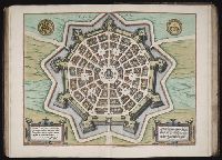
- Cicogna, Pasquale, 1509-1595
- Published / Created:
- 1593
- Call Number:
- 1975 Folio 41
- Collection Title:
- Civitates orbis terrarvm ...
- Image Count:
- 1
- Resource Type:
- Maps, Atlases & Globes
- Subject (Geographic):
- Palmanova (Italy) --Buildings, structures, etc. --Designs and plans
- Subject (Name):
- Hierat, Anton, fl.1597-1627, Hogenberg, Abraham, fl. 1608-1653, and Hogenberg, Franz, d. 1590?
- Subject (Topic):
- Cities and towns, Medieval
- Collection Created:
- [Coloniae Agrippinae, 1572]-1618
- Found in:
- Beinecke Rare Book and Manuscript Library > Palma