Search
You Searched For
Search Results
- Published / Created:
- 1850
- Call Number:
- 1976 Folio 96
- Collection Title:
- A new universal atlas containing maps of the various empires, kingdoms, states and republics of the
- Image Count:
- 1
- Resource Type:
- Maps, Atlases & Globes
- Publisher:
- Thomas, Cowperthwait & Co
- Subject (Geographic):
- Connecticut
- Collection Created:
- Philadelphia, Cowperthwait, DeSilver & Butler, 1854, c1850
- Found in:
- Beinecke Rare Book and Manuscript Library > 10. Map of Connecticut
- Published / Created:
- 1833
- Call Number:
- 2002 Folio 97
- Collection Title:
- Tanner’s universal atlas : subscription price $1.00 a number, seperate [sic] numbers $1.50 each
- Image Count:
- 1
- Resource Type:
- Maps, Atlases & Globes
- Alternative Title:
- II.-Map of the state of Maine
- Description:
- Plate identified as "II" on atlas cover and "5" on map. and Verso blank.
- Subject (Geographic):
- Maine
- Collection Created:
- Philadelphia : Published by the author, 1833-1836
- Found in:
- Beinecke Rare Book and Manuscript Library > A new map of Maine
- Published / Created:
- 1833
- Call Number:
- 1976 Folio 98
- Collection Title:
- A new universal atlas, containing maps of the various empires, kingdoms, states and republics of
- Image Count:
- 1
- Resource Type:
- Maps, Atlases & Globes
- Subject (Geographic):
- Maine
- Collection Created:
- Philadelphia, Published by the author, 1836
- Found in:
- Beinecke Rare Book and Manuscript Library > A new map of Maine
- Published / Created:
- 1850
- Call Number:
- 1976 Folio 96
- Collection Title:
- A new universal atlas containing maps of the various empires, kingdoms, states and republics of the
- Image Count:
- 1
- Resource Type:
- Maps, Atlases & Globes
- Publisher:
- Thomas, Cowperthwait & Co
- Subject (Geographic):
- Maine
- Collection Created:
- Philadelphia, Cowperthwait, DeSilver & Butler, 1854, c1850
- Found in:
- Beinecke Rare Book and Manuscript Library > A new map of Maine
- Call Number:
- 1976 Folio 94
- Collection Title:
- A new universal atlas containing maps of the various empires, kingdoms, states and republics of the
- Image Count:
- 1
- Resource Type:
- Maps, Atlases & Globes
- Subject (Geographic):
- Maine
- Collection Created:
- Philadelphia, S.A. Mitchell, 1849
- Found in:
- Beinecke Rare Book and Manuscript Library > A new map of Maine
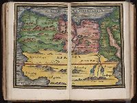
- Published / Created:
- [1542]
- Call Number:
- Taylor 86
- Collection Title:
- Rvdimenta cosmographica
- Image Count:
- 1
- Subject (Geographic):
- Africa, Arab countries, and Middle East
- Subject (Topic):
- Cosmography, Early maps, and Geography, Medieval
- Collection Created:
- Impressvm in inclyta Transylvaniae Corona 1542
- Found in:
- Beinecke Rare Book and Manuscript Library > Africa
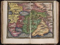
- Published / Created:
- [1542]
- Call Number:
- Taylor 86
- Collection Title:
- Rvdimenta cosmographica
- Image Count:
- 1
- Subject (Geographic):
- Asia and India
- Subject (Topic):
- Cosmography, Early maps, and Geography, Medieval
- Collection Created:
- Impressvm in inclyta Transylvaniae Corona 1542
- Found in:
- Beinecke Rare Book and Manuscript Library > Asia
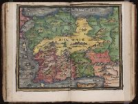
- Published / Created:
- [1542]
- Call Number:
- Taylor 86
- Collection Title:
- Rvdimenta cosmographica
- Image Count:
- 1
- Subject (Geographic):
- Turkey
- Subject (Topic):
- Cosmography, Early maps, and Geography, Medieval
- Collection Created:
- Impressvm in inclyta Transylvaniae Corona 1542
- Found in:
- Beinecke Rare Book and Manuscript Library > Asia Minor
- Creator:
- Moll, Herman, d. 1732
- Published / Created:
- [178-?]
- Call Number:
- 1973 Folio 113
- Image Count:
- 2
- Resource Type:
- Maps, Atlases & Globes
- Alternative Title:
- New and curious set of sixty two maps.
- Description:
- "The United States of North America, with the British & Spanish territories": no. 46. and Title-page engraved.
- Publisher:
- Printed for R. Wilkinson, at No. 58 in Cornhill
- Subject (Topic):
- Atlases--Early works to 1800 and Geography--Early works to 1800
- Found in:
- Beinecke Rare Book and Manuscript Library > Atlas minor: or A new and curious set of sixty two maps, in which are shewn all the empires, kingdoms, countries, states in all the known parts of the earth ... by Herman Moll ...
- Creator:
- Braun, Georg, 1540 or 1-1622
Hierat, Anton, fl.1597-1627
Hogenberg, Abraham, fl. 1608-1653
Hogenberg, Franz, d. 1590?
- Published / Created:
- 1572]-1618
- Call Number:
- 1975 Folio 41
- Image Count:
- 1
- Resource Type:
- Maps, Atlases & Globes
- Alternative Title:
- Civitates orbis terrarum ...
- Publisher:
- [Coloniae Agrippinae,
- Subject (Geographic):
- Rome--Antiquities--Early works to 1800 and Rome--Antiquities--Maps
- Subject (Topic):
- Cities and towns, Medieval and Maps, Pictorial -- (LC)
- Found in:
- Beinecke Rare Book and Manuscript Library > Civitates orbis terrarvm ...