Skip to search
Skip to main content
Skip to first result
Search
You Searched For
Date
1710 - 1719
Format
cartographic
Genre
Hand coloring
Date Created
1710 to 1719
New Search
Search Results
Creator:
Published / Created:
1716?]
Call Number:
11 1716
Container / Volume:
BRBL_00680
Image Count:
1
Resource Type:
Maps, Atlases & Globes
Description:
Cross collection no. 28., Includes text, two celestial insets, two insets of solstices, two panoramic views, and illustrations., and Relief shown pictorially.
Publisher:
s.n.,
Subject (Topic):
World maps--Early works to 1800
Found in:
Beinecke Rare Book and Manuscript Library > Planiglobii terrestris cum utroq hemisphaerio caelesti generalis repraesentatio [cartographic material] : quam ex novissimis probatissimisque recentium geographorum scriptis concinnatam, multisq[ue] phaenomenis illustratam / publice proponit Io. Bapt. Hom
Creator:
Published / Created:
ca. 1715
Call Number:
1975 Folio 31
Collection Title:
[Atlas factice of 42 maps, produced by the Homann Erben firm]
Image Count:
1
Publisher:
Johann Baptist Homann
Subject (Geographic):
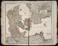
Denmark --Maps --Early works to 1800
Subject (Topic):
Atlases, German --Early works to 1800
Collection Created:
[Nuremberg,
Found in:
Beinecke Rare Book and Manuscript Library > Regni Daniae, in quo sunt Ducatus Holsatia et Slesvicum, insulae Danicae, provinciae Iutia, Scania, Bleckingia, nova tabula / [cartographic material] / edita a Io. Baptista Homanno ; et aucta secundum geographiam novissimam Iohann Huebneri, I.U.L
Creator:
Published / Created:
[ca. 1710]
Call Number:
1983 Folio 23
Collection Title:
[Atlas factice of 50 maps, primarily by Johann Baptist Homann and/or issued by the Homann Erben
Image Count:
1
Publisher:
[Johann Baptist Homann]
Subject (Geographic):
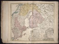
Baltic States --Maps --Early works to 1800, Finland --Maps --Early works to 1800, and Sweden --Maps --Early works to 1800
Collection Created:
[Nuremberg : Homann Erben, 1710-1786]
Found in:
Beinecke Rare Book and Manuscript Library > Regni Sueciae in omnes suas subjacentes provincias accurate divisi tabula generalis [cartographic material] / edita a Ioh. Bapt. Homanno
Creator:
Published / Created:
ca. 1715
Call Number:
1975 Folio 31
Collection Title:
[Atlas factice of 42 maps, produced by the Homann Erben firm]
Image Count:
1
Alternative Title:
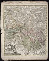
Circulus Rhenanus inferior
Publisher:
Johann Baptist Homann
Subject (Geographic):
Rhine River Valley --Maps --Early works to 1800
Subject (Topic):
Atlases, German --Early works to 1800
Collection Created:
[Nuremberg,
Found in:
Beinecke Rare Book and Manuscript Library > S.R.I. circulus Rhenanus inferior sive electorum Rheni [cartographic material] : complectens tres archiepiscopatus, Moguntinum, Coloniensem et Trevirensem, Palatinatum Rheni, Comit. Beilstein, Newenaer, Inf. Isenburg; et Reiferscheit / repraesentatus a Io
Creator:
Published / Created:
ca. 1715
Call Number:
1975 Folio 31
Collection Title:
[Atlas factice of 42 maps, produced by the Homann Erben firm]
Image Count:
1
Publisher:
Johann Baptist Homann
Subject (Geographic):
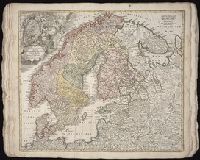
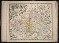
Scandinavia --Maps --Early works to 1800
Subject (Topic):
Atlases, German --Early works to 1800
Collection Created:
[Nuremberg,
Found in:
Beinecke Rare Book and Manuscript Library > Scandinavia [cartographic material] : complectens Sueciae, Daniae & Norvegiae Regna. / ex tabulis Ioh. Baptistae Homanni
Creator:
Published / Created:
[ca. 1715]
Call Number:
1983 Folio 23
Collection Title:
[Atlas factice of 50 maps, primarily by Johann Baptist Homann and/or issued by the Homann Erben
Image Count:
1
Publisher:
[Johann Baptist Homann]
Subject (Geographic):
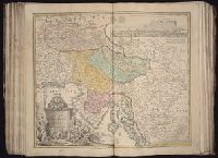
Carniola (Slovenia) --Maps --Early works to 1800, Croatia --Maps --Early works to 1800, and Ljubljana (Slovenia) --Maps, Pictorial --Early works to 1800
Collection Created:
[Nuremberg : Homann Erben, 1710-1786]
Found in:
Beinecke Rare Book and Manuscript Library > Tabula Ducatus Carnioliae, vindorum Marchiae et Histriae et mente Mustr. quondam J.B. Valvasorii / concinnatia et exhibita a Io. Bapt. Homanno, S.C.M. Geogr
Creator:
Published / Created:
ca. 1715
Call Number:
1975 Folio 31
Collection Title:
[Atlas factice of 42 maps, produced by the Homann Erben firm]
Image Count:
1
Publisher:
Johann Baptist Homann
Subject (Geographic):
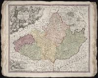
Moravia (Czech Republic) --Maps --Early works to 1800
Subject (Topic):
Atlases, German --Early works to 1800
Collection Created:
[Nuremberg,
Found in:
Beinecke Rare Book and Manuscript Library > Tabula generalis Marchionatus Moraviae in sex circulos divisae [cartographic material] : quos mandato Caesareo accurate emensus / hac mappa delineatos exhibet Ioh. Christoph. Mueller, S.C.M. Capitan ; editore Joh. Bapt. Homanno
Creator:
Published / Created:
[ca. 1715]
Call Number:
1983 Folio 23
Collection Title:
[Atlas factice of 50 maps, primarily by Johann Baptist Homann and/or issued by the Homann Erben
Image Count:
1
Publisher:
[Johann Baptist Homann]
Subject (Geographic):
Moravia (Czech Republic) --Maps --Early works to 1800
Collection Created:
[Nuremberg : Homann Erben, 1710-1786]
Found in:
Beinecke Rare Book and Manuscript Library > Tabula generalis Marchionatus Moraviae in sex circulos divisae [cartographic material] : quos mandato Caesareo accurate emensus / hac mappa delineatos exhibet Ioh. Christoph. Muå¬ller, S.C.M. Capitan ; editore Joh. Bapt. Homanno
Creator:
Published / Created:
ca. 1715
Call Number:
1975 Folio 31
Collection Title:
[Atlas factice of 42 maps, produced by the Homann Erben firm]
Image Count:
1
Alternative Title:
Tabula marchionatus Brandenburgici et ducatus Pomeraniae
Publisher:
Johann Baptist Homann
Subject (Geographic):
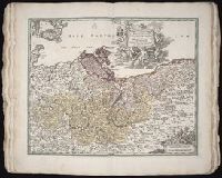
Brandenburg (Germany) --Maps --Early works to 1800 and Pomerania (Poland and Germany) --Maps --Early works to 1800
Subject (Topic):
Atlases, German --Early works to 1800
Collection Created:
[Nuremberg,
Found in:
Beinecke Rare Book and Manuscript Library > Tabvla marchionatvs Brandenbvrgici et dvcatvs Pomeraniae [cartographic material] : quae sunt pars septentrionalis circuli Saxoniae superioris / novissime edita a Ioh. Baptista Homanno
Creator:
Published / Created:
17--]
Call Number:
1978 47
Collection Title:
Atlas minor.
Image Count:
1
Alternative Title:
Part of ye Islands of America &c.
Description:
Imperfect: title page wanting; title supplied by National Union catalog of pre 1956 imprints. Maps no. 1, 3-5, 28, 36-38, 47-53, 58 wanting.
Subject (Name):
Bowles, Carington, 1724-1793, Bowles, John, 1701-1779 Publisher, and Bowles, Thomas Publisher
Subject (Topic):
Geography--Early works to 1800
Collection Created:
London,
Found in:
Beinecke Rare Book and Manuscript Library > The Island of St. Christophers By Her. Moll Geographer
Branch:v1.61.6 ,Deployed:2024-06-12T09:55:37-04:00