Chernyshov, Ivan Georgievich Dury, Andrew., creator Sayer, Robert, 1725-1794
Published / Created:
1787 October 24
Call Number:
1982 Folio 10
Image Count:
1
Alternative Title:
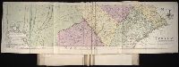
Map of the present seat of war, between the Russians, Poles, and Turk
Description:
Also shows parts of Hungary and Poland., Includes paste-on addition to northwestern sheet depicting Bosnia, Herzegovina, and the Dalmatian Coast., No. 26 of 43 maps bound together in composite atlas., Prime meridian: Ferro., Relief shown pictorially., Scale [ca. 1:2,500,000]., and Sheets mounted together to form 2 sheets.
Publisher:
Wm. Faden
Subject (Geographic):
Black Sea --Maps --Early works to 1800 and Russia --Maps --Early works to 1800
Subject (Topic):
Russo-Turkish War, 1787-1792 --Maps --Early works to 1800
Map of the improved part of the province of Pennsylvania
Description:
BEIN 2003 Folio 85: No. 20 of 45 maps bound together with binder's spine title: Atlas of America; ms. table of contents. Bookplate: Robinson. Bookplate of Paul Mellon., Hand colored., Relief shown pictorially., Scale [ca. 1:250,000]., and Shows county boundaries.
Publisher:
Sold by the author, Nicholas Scull
Subject (Geographic):
Pennsylvania -- Administrative and political divisions -- Maps -- Early works to 1800 and Pennsylvania -- Maps -- Early works to 1800
Lansdowne, William Petty, Marquis of, 1737-1805 Park, Moses, 1738-1828, creator
Published / Created:
1766
Call Number:
2003 Folio 85
Image Count:
1
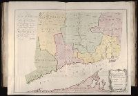
Alternative Title:
Plan of the colony of Connecticut in North-America
Description:
Available also through the Library of Congress Web site as a raster image., BEIN 2003 Folio 85: No. 19 of 45 maps bound together with binder's spine title: Atlas of America; ms. table of contents. Bookplate: Robinson. Bookplate of Paul Mellon., Hand colored., LC Maps of North America, 1750-1789,, Relief shown pictorially., Scale [ca. 1:275,000]., and Shows counties, towns, rivers, and post roads.
Publisher:
s.n
Subject (Geographic):
Connecticut -- Administrative and political divisions -- Maps -- Early works to 1800 and Connecticut -- Maps -- Early works to 1800
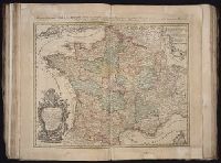
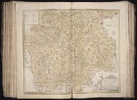
[Atlas factice of 50 maps, primarily by Johann Baptist Homann and/or issued by the Homann Erben
Image Count:
1
Alternative Title:
Cours de Danube
Publisher:
Cura Homannianorum Heredum, C.P.S.C.M
Subject (Geographic):
Balkan Peninsula --Maps --Early works to 1800, Danube River Valley --Maps --Early works to 1800, Europe, Central --Maps --Early works to 1800, and Europe, Southern --Maps --Early works to 1800
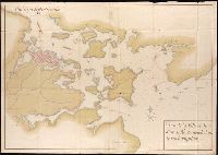
Henri Crublier d'Opterre journal and maps, [1776]-1783.
Container / Volume:
Bsd folder 10
Image Count:
3
Subject (Geographic):
America--Maps--Early works to 1800, Portsmouth (N.H.)--Maps--Early works to 1800, and United States--History--Revolution, 1775-1783--Maps--Early works to 1800.
All volumes bound to match 1973 Folio 72. Factitious collection of about 549 maps taken from the atlases of the 17th and the beginning of the 18th cent., put together with the title "Atlas" and bound in 6 volumes. These volumes originally bore the imprint: Amstelaedamii apvd Reiniervm & Josvam Ottens. Over these words on the title-pages of v. 1-2, 4-6 is the name of Henrik de Leth who painted them. Volume 3 has only the erased imprint of Ottens., For fuller description see Phillips 3448 and C. Koeman's Atlantes Neerlandici, bibliography of terrestrial, maritime and celestial atlases and pilot books, published in the Netherlands up to 1800, Amsterdam c1967-71, v. 2, p. 63-83., and Maps by P. Schenck and son, G. Valck, F. de Wit, N. Visscher and others.
Publisher:
chez J. Covens & C. Mortier,
Subject (Geographic):
Denmark --Maps --Early works to 1800
Subject (Name):
Reiner et Josua Ottens (Firm), Schenk, Peter, 1660-1718 or 1719., and Valck, G. (Gerard), 1651 or 1652-1726.