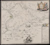
Карта : описи и промеру глубины, части дниепровскаго Лимана и реки Буга до Николаева / сочинена флота господином капитанъ лейтнантомъ Александром Савицкимъ 1793 года.
Description:
Depths shown by soundings.
Subject (Geographic):
Dnieper River--Maps--Early works to 1800.
Subject (Name):
Savit︠s︡kiĭ, Aleksandr, -1799. and Савицкий, Александр, -1799.
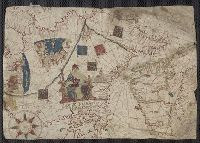
Contains five compass roses., Decoration: city views with banners, figures holding armorial shields, animals, and Jesus Christ on the cross flanked by the Virgin Mary and Mary Magdalene., Includes degrees of latitude along left edge: 18°N to 63°N., Includes two North Atlantic islands "Frislandia" and "Stilanda" in upper left corner and inset map of the world in the lower center., Pen-and-ink in black, red, blue and green., Portolan chart with seaport names given for all coastlines., and Title devised by cataloger; last two numerals of date have been altered.
Subject (Geographic):
Baltic Sea--Maps--Early works to 1800, Mediterranean Sea--Maps--Early works to 1800, and North Atlantic Ocean--Maps--Early works to 1800