Skip to search
Skip to main content
Skip to first result
Search
You Searched For
Date
1700 - 1799
Format
cartographic
Genre
Manuscript maps
Date Created
1700 to 1799
New Search
Search Results
Published / Created:
1714
Call Number:
732 F963 1714
Container / Volume:
BRBL_00708
Image Count:
1
Resource Type:
Maps, Atlases & Globes
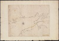
Description:
Color: pen and ink drawing with some yellow. and Preliminary record.
Subject (Geographic):
Nova Scotia--Maps, Manuscript--Early works to 1800
Found in:
Beinecke Rare Book and Manuscript Library > A Draft of the Bay of Fundy by John Wells.
Published / Created:
1774
Call Number:
771 1774
Container / Volume:
BRBL_00713
Image Count:
1
Resource Type:
Maps, Atlases & Globes
Description:
Color: water color.
Subject (Geographic):
New York--Maps--Early works to 1800
Found in:
Beinecke Rare Book and Manuscript Library > A Map of the Province of New York as divided into Counties together with the adjacent provinces. Compiled from the latest Maps and Actual Surveys. Will:Cockburn.
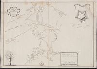
Published / Created:
[175-?]
Call Number:
732 1750
Container / Volume:
BRBL_00708
Image Count:
1
Resource Type:
Maps, Atlases & Globes
Alternative Title:
Map of the surveyed parts of Nova Scotia and Plan of Fort Cumberland at BeauSejour.
Description:
Includes "A plan of Fort Cumberland at BeauSejour" (scale [ca. 1:985]) and ill., Relief shown by hachures., and Shows area between Annapolis Basin and Minas Basin, and "Rr. Memramcook" to the north and "Cape le Have," "Margrets Bay" and "Sambro Rocks and Ledges" to the south.
Subject (Geographic):
Fort Cumberland (N.B.)--Maps, Manuscript and Nova Scotia--Maps, Manuscript
Found in:
Beinecke Rare Book and Manuscript Library > A Map of the surueyed parts of Noua Scotia.
Published / Created:
1798
Call Number:
27cea 1798
Container / Volume:
BRBL_00700
Image Count:
1
Resource Type:
Maps, Atlases & Globes
Description:
Original manuscript map.
Publisher:
Laurie & Whittle,
Subject (Geographic):
Indonesia--Maps, Manuscript--Early works to 1800
Found in:
Beinecke Rare Book and Manuscript Library > A New Chart of the Eastern Straits or the Straits of the East of Java, with a part of the Banda Sea; corrected and improved chiefly from the observation of Captn. - Williams.
Published / Created:
[ca. 1789]
Call Number:
6555cea 1789
Container / Volume:
BRBL_00708
Image Count:
3
Resource Type:
Maps, Atlases & Globes
Description:
A plan of the Cove at Bassa with the adjacent roads., Entrace of the River Serra Leone vulgo Sierra Leon, 1775., Insets: Lagos and its Channels by Capt. Horsely of Liverpool 1789., and The Course of Gato or Regio Creek with the Entrance of River Benin by Capt. Archd. Dalzel, 1785.
Publisher:
Robert Sayer,
Subject (Geographic):
Ghana--Maps, Manuscript--Early works to 1800
Found in:
Beinecke Rare Book and Manuscript Library > A New Survey of that part of the Coast of Africa comprised between Cape Verga and Cape Formoso, including chiefly the Windward and Gold Coasts in which the Latitudes of all the Principal Places are determined by Actual observations, the bearings and cours
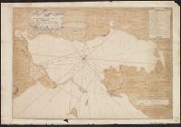
Published / Created:
1711
Call Number:
764 B65 1711
Container / Volume:
BRBL_00710
Image Count:
1
Resource Type:
Maps, Atlases & Globes
Description:
Color: ink and yellow. and Manuscript map has additions from Revolutionary War period, showing forts, etc. Note states observations are by Capn. Edmond Halley.
Subject (Geographic):
Boston (Mass.)--Maps--Early works to 1800
Found in:
Beinecke Rare Book and Manuscript Library > A New plan of the Harbour of Boston in New England. Lat. 42, 29 North. Long. 71 West. Surveyed by Order of the Commissioners of her Majesty's Navy.
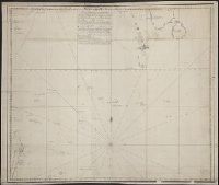
Published / Created:
1745
Call Number:
7325cea L93 1745
Container / Volume:
BRBL_00709
Image Count:
1
Resource Type:
Maps, Atlases & Globes
Description:
Color: Pen and ink drawing. and Notes in right hand corner.
Subject (Geographic):
Louisbourg (N.S.)--Maps, Manuscript--Early works to 1800
Found in:
Beinecke Rare Book and Manuscript Library > A Plan of the Harbour and Fortifications of Louisburg. The Harbour Survey'd by Capt. Phil: Durell. The fortifications by Capt. Will: Henry Bastide. Anne. 1745.
Published / Created:
1758
Call Number:
7325 L93 1758A
Container / Volume:
BRBL_00709
Image Count:
1
Resource Type:
Maps, Atlases & Globes
Description:
Color: ink drawing with red, green and gold color. and Photostat included in folder.
Subject (Geographic):
Louisbourgh (N.S.)--Maps, Manuscript--Early works to 1800
Found in:
Beinecke Rare Book and Manuscript Library > A Plan of the Town and Harbour of Louisburg ... 1758. By Lieut. Joseph Norwood.
Published / Created:
[1780]
Call Number:
29cea 1780
Container / Volume:
BRBL_00701
Image Count:
1
Resource Type:
Maps, Atlases & Globes
Description:
Manuscript map.
Subject (Geographic):
Indian Ocean--Maps, Manuscript--Early works to 1800
Found in:
Beinecke Rare Book and Manuscript Library > A Plane Chart of several Islands Bank Shoals & Soundings ...
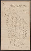
Published / Created:
[1750?]
Call Number:
763fb Su87 1750
Container / Volume:
BRBL_00710
Image Count:
1
Resource Type:
Maps, Atlases & Globes
Description:
Color: pen and ink drawing. and Note located in upper right hand corner.
Subject (Geographic):
Vermont--Maps, Manuscript--Early works to 1800
Found in:
Beinecke Rare Book and Manuscript Library > A Sketch of the Township of Sutton, lately Billymead, showing the number of the lot and to which propietor each lot is rett.
Branch:v1.61.8 ,Deployed:2024-06-20T11:14:48-04:00