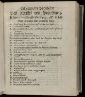
"Beylage des Projects, welches die Sorbonne Anno 1717. dem Czaren wegen Vereinigung der Römisch-Catholischen und Russisch-Griechischen Religion übergeben, und wovon im vorhergehenden Tractat gedacht worden": p. 433-444 (vol. 1)., "Das Leben und die Gewohnheiten der Ostiaken, eines Volcks, das bis unter dem Polo Arctico wohnet; wie selbiges seit Anno 1712 aus dem Heydenthum zur Christlichen Griechischen Religion gebracht worden, mit etlichen curieusen Anmerkkungen vom Königreiche Siberien und dem Freto Nassovio oder Waigats in der Gefangenschaft beschrieben von Johann Bernhard Müllern": p. [169]-214 (vol. 1)., "Journal von Lorentz Langens Reise nach China": p. 72-87 (vol. 1)., and Map of St. Petersburg (34.5 x 41 cm.) bound in between p. 432-433, with added directory following.
Publisher:
Bey Nicolai Försters und Sohnes ... ,
Subject (Geographic):
Russia--Description and travel and Saint Petersburg (Russia) -- Maps -- Early works to 1800
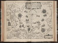
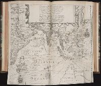
Tertia pars Indiae Orientalis ... / de Germanico in Latinum translata, & bono ordine disposita a
Image Count:
1
Description:
In pencil on verso: Part 3 p 132.
Subject (Geographic):
Arctic Ocean --Maps, Arctic regions --Discovery and exploration --Maps --Early works to 1800, Finland --Maps --Early works to 1800, Norway --Maps, and Sweden --Maps
Collection Created:
Francofurti : Excudebat Matthaeus Beckerus, anno MDCI [1601]
Gussefeld, F. L. (Franz Ludwig), 1744-1807 Homann Erben (Firm)
Published / Created:
1786
Call Number:
1983 Folio 23
Collection Title:
[Atlas factice of 50 maps, primarily by Johann Baptist Homann and/or issued by the Homann Erben
Image Count:
1
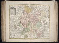
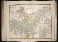
Alternative Title:
Carte geographique du Cercle de Haut-Rhin and Charte ueber die am Ober-Rhein zerstreut liegende Laender des Ober-Rheinischen Kreise
Publisher:
Bey denen Homaennischen Erben
Subject (Geographic):
Baden-Wu?rttemberg (Germany) --Maps --Early works to 1800, Hesse (Germany) --Maps --Early works to 1800, North Rhine-Westphalia (Germany) --Maps --Early works to 1800, and Rhineland-Palatinate (Germany) --Maps --Early works to 1800
Gussefeld, F. L. (Franz Ludwig), 1744-1807 Homann Erben (Firm) Schmidt, I. M.
Published / Created:
1783
Call Number:
1983 Folio 23
Collection Title:
[Atlas factice of 50 maps, primarily by Johann Baptist Homann and/or issued by the Homann Erben
Image Count:
1
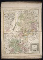
Alternative Title:
Carte geographique contenant le cours du Rhin, de la Meuse, & de la Moselle avec les cercles du haut- & bas-Rhin, le Duchee de Lorraine & d’Elsas & cc
Publisher:
Bey denen Homaen[n]ischen Erben
Subject (Geographic):
Germany, Southern --Maps --Early works to 1800, Hesse (Germany) --Maps --Early works to 1800, and Rhineland-Palatinate (Germany) --Maps --Early works to 1800
Gussefeld, F. L. (Franz Ludwig), 1744-1807 Homann Erben (Firm)
Published / Created:
1783
Call Number:
1983 Folio 23
Collection Title:
[Atlas factice of 50 maps, primarily by Johann Baptist Homann and/or issued by the Homann Erben
Image Count:
1
Alternative Title:
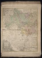
Circuli superioris Saxoniae pars meridionalis, Ducatum, Electoratum & Principatus Ducum Saxoniae, Princip. Anhalt. Comit. Schwarzburg, Mansfeld, Stolberg &cc
Publisher:
[Homann Erben]
Subject (Geographic):
Brandenburg (Germany) --Maps --Early works to 1800, Saxony (Germany) --Maps --Early works to 1800, Saxony-Anhalt (Germany) --Maps --Early works to 1800, and Thuringia (Germany) --Maps --Early works to 1800