
You Searched For
1 - 9 of 9
Search Results
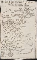
- Call Number:
- Taylor 322
- Collection Title:
- Nevv Englands prospect; a true, lively, and experimentall description of that part of America
- Image Count:
- 1
- Description:
- Preceding p. 1. and Teaching resource: Professor John Mack Faragher, History 141: The American West.
- Subject (Geographic):
- Massachusetts --Description and travel
- Subject (Topic):
- --Massachusetts
- Collection Created:
- London, Printed by T. Cotes for I. Bellamie, 1634
- Found in:
- Beinecke Rare Book and Manuscript Library > The south part of New-England, as it is planted this yeare, 1634
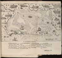
3.
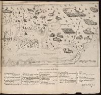
- Call Number:
- Taylor 257
- Collection Title:
- Les voyages dv sievr de Champlain Xaintongeois, capitaine ordinaire pour le Roy, en la marine
- Image Count:
- 1
- Description:
- Bound in after p. 132.
- Subject (Geographic):
- Massachusetts --Pictorial works
- Subject (Name):
- Pelletier, David
- Subject (Topic):
- Indians of North America --Canada
- Collection Created:
- A Paris : Chez Iean Berjon, rue S. Iean de Beauuais, au Cheual volant, & en sa boutique au Palais, a la gallerie des prisonniers, MDCXIII [1613]. Avec privilege dv Roy
- Found in:
- Beinecke Rare Book and Manuscript Library > Port Fortune

- Creator:
- Russell, John, fl. 1733-1795
- Published / Created:
- 1795 February 7
- Call Number:
- 1986 102
- Collection Title:
- An historical, geographical, commercial, and philosophical view of the American United States, and
- Image Count:
- 1
- Description:
- Engraved by Russell, Constitution R., Grays Inn La. and Facing p. 2.
- Publisher:
- Publish'd as the Act directs, by H.D. Symonds, No. 20 Pater Noster Row
- Subject (Geographic):
- America --Description and travel, America --History --To 1810, New England --Maps --Early works to 1800, United States --Description and travel, and United States --Maps --Early works to 1800
- Collection Created:
- London, Printed for the editor; J. Ridgway [etc.] 1795
- Found in:
- Beinecke Rare Book and Manuscript Library > Map of the northern, or, New England states of America. Comprehending Vermont, New Hampshire, District of Main, Massachusetts, Rhode-Island, and Connecticut
5.
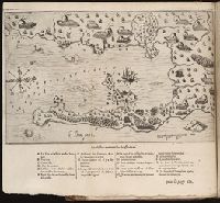
- Call Number:
- Taylor 257
- Collection Title:
- Les voyages dv sievr de Champlain Xaintongeois, capitaine ordinaire pour le Roy, en la marine
- Image Count:
- 1
- Description:
- Bound in after p. 118.
- Subject (Geographic):
- Massachusetts --Pictorial works
- Subject (Name):
- Pelletier, David
- Subject (Topic):
- Indians of North America --Canada
- Collection Created:
- A Paris : Chez Iean Berjon, rue S. Iean de Beauuais, au Cheual volant, & en sa boutique au Palais, a la gallerie des prisonniers, MDCXIII [1613]. Avec privilege dv Roy
- Found in:
- Beinecke Rare Book and Manuscript Library > Le Beau port
6.
- Call Number:
- Taylor 257
- Collection Title:
- Les voyages dv sievr de Champlain Xaintongeois, capitaine ordinaire pour le Roy, en la marine
- Image Count:
- 1
- Description:
- Bound in after p. 88.
- Subject (Geographic):
- Massachusetts --Pictorial works
- Subject (Name):
- Pelletier, David
- Subject (Topic):
- Indians of North America --Canada
- Collection Created:
- A Paris : Chez Iean Berjon, rue S. Iean de Beauuais, au Cheual volant, & en sa boutique au Palais, a la gallerie des prisonniers, MDCXIII [1613]. Avec privilege dv Roy
- Found in:
- Beinecke Rare Book and Manuscript Library > Malle Barre

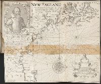
- Creator:
- Smith, John, 1580-1631
- Published / Created:
- 1631
- Call Number:
- Taylor 316
- Image Count:
- 2
- Alternative Title:
- New England: the most remarqueable parts thus named by the high and mighty Prince Charles, nowe King of great Britaine [map] and Path-way to experience to erect a plantation.
- Description:
- Imperfect: damp-stained; added port. of Charles I., Map with portrait of Capt. Smith in corner: New England ... / observed and described by Captayn John Smith. 1614. Pendleton's Lithography, Boston. Drawn by J. Eddy. London, printed by Geor: Low., Signatures: A-F⁴., and Teaching resource: Professor John Mack Faragher, History 141: The American West.
- Publisher:
- Printed by I. Haviland, and are to be sold by R. Milbovrne,
- Subject (Geographic):
- Massachusetts--History--Colonial period
- Subject (Name):
- Pasaeus, Simon and Reeve, James
- Found in:
- Beinecke Rare Book and Manuscript Library > Advertisements for the unexperienced planters of New-England, or anywhere, or, The path-way to experience to erect a plantation : With the yearely proceedings of this country in fishing and planting, since the yeare 1614. to the yeare 1630. and their present estate. Also how to prevent the greatest inconveniences, by their proceedings in Virginia, and other plantations, by approved examples. With the countries armes, a description of the coast, harbours, habitations, land-markes, latitude and longitude: with the map, allowed by our royall King Charles. By Captaine Iohn Smith, sometimes governour of Virginia, and admirall of Nevv-England.
8.
- Creator:
- Eddy, J.
Lowe, George, fl. 1613?-ca. 1615? - Published / Created:
- 1614-16
- Call Number:
- Zd 176
- Collection Title:
- Path-way to experience to erect a plantation
- Image Count:
- 1
- Abstract:
- With engraved portrait of John Smith in upper left corner.
- Description:
- From an original drawn by Robert Clerke, Simon Paseus (?), lithographer, printed in London by Geor. Low., Observed and described by Captayn John Smith, 1614., Preceding table of contents., and Teaching resource: Professor John Mack Faragher, History 141: The American West.
- Publisher:
- Pendleton's Lithography
- Subject (Geographic):
- Massachusetts --History --Colonial
- Subject (Name):
- Clarke, Robert, fl. 1616
- Collection Created:
- London, Printed by I. Haviland, and are to be sold by R. Milbovrne, 1631
- Found in:
- Beinecke Rare Book and Manuscript Library > New England: the most remarqueable parts thus named by the high and mighty Prince Charles, Prince of Great Britaine
9.

- Published / Created:
- 1774 November 29
- Call Number:
- 1975 Folio 51
- Collection Title:
- The American atlas; or, A geographical description of the whole continent of America; wherein are
- Image Count:
- 1
- Resource Type:
- Maps, Atlases & Globes
- Description:
- Stamped on verso: 16.
- Subject (Geographic):
- Massachusetts --Maps --Early works to
- Subject (Name):
- Holland, Samuel, 1728-1801
- Collection Created:
- London, Printed by R. Sayer and J. Bennett, 1776
- Found in:
- Beinecke Rare Book and Manuscript Library > A map of the most inhabited part of New England, containing the provinces of Massachusets Bay and New Hampshire, with the colonies of Conecticut and Rhode Island, divided into counties and townships: the whole composed from actual surveys and its situatio