Search
You Searched For
Search Results
- Creator:
- Hendges, M
- Published / Created:
- 1904
- Call Number:
- 70gme 1904
- Container / Volume:
- BRBL_00359
- Image Count:
- 1
- Resource Type:
- Maps, Atlases & Globes
- Subject (Topic):
- Railroads--Latin America--Maps
- Found in:
- Beinecke Rare Book and Manuscript Library > Intercontinental railway map : prepared under the direction of the permanent Pan American Railway Committee authorized by the Second International Conference of American States / M. Hendges.
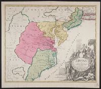
- Creator:
- Homann, Johann Baptist, 1663-1724
- Published / Created:
- ca. 1730]
- Call Number:
- 755 1714A
- Container / Volume:
- BRBL_00425
- Image Count:
- 1
- Resource Type:
- Maps, Atlases & Globes
- Description:
- Title in Latin. Place names in Latin
- Found in:
- Beinecke Rare Book and Manuscript Library > Virginia, Marylandia et Carolina in America septentrionali Brittannorum industria excultæ / repraesentatae à Ioh. Bapt. Homann, S.C.M. Geog.
- Call Number:
- CE143 A28
- Collection Title:
- An account of the Spanish settlements in America. In four parts ... To which is annexed, a succinct
- Image Count:
- 1
- Subject (Geographic):
- Latin America --Description and travel
- Found in:
- Beinecke Rare Book and Manuscript Library > A New general map of America drawn from several accurate particular maps and charts and regulated by astronomical observations
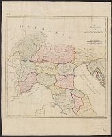
- Creator:
- Neele, Samuel John, 1758-1824
- Published / Created:
- 1790
- Call Number:
- 400 1790
- Container / Volume:
- BRBL_00233
- Image Count:
- 1
- Resource Type:
- Maps, Atlases & Globes
- Description:
- Title in English, place names in Latin.
- Found in:
- Beinecke Rare Book and Manuscript Library > The northern part of ancient Italy / engrav'd by Samuel John Neele.
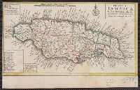
- Published / Created:
- 1737]
- Call Number:
- 8555 1737
- Container / Volume:
- BRBL_00695
- Image Count:
- 1
- Resource Type:
- Maps, Atlases & Globes
- Description:
- Title in Latin, explanations in German
- Found in:
- Beinecke Rare Book and Manuscript Library > Insula Iamaica [cartographic material] : in suas parochias divisa et secundum exemplar primitivum Londinense excusa.
- Creator:
- Kokkins, John M
- Published / Created:
- c1943.
- Call Number:
- 48j 1943
- Container / Volume:
- BRBL_00265
- Image Count:
- 1
- Resource Type:
- Maps, Atlases & Globes
- Description:
- . -- 1190 A.D. and during the Latin occupation
- Found in:
- Beinecke Rare Book and Manuscript Library > The Hellenic World, from 480 B.C. to 1940 A.D [cartographic material] / historical maps compiled and drawn by John M. Kokkins assisted by Richard C. Guthridge ...
- Creator:
- Hollar, Wenceslaus, 1607-1677
- Published / Created:
- 1647. and 1906-1907.
- Call Number:
- 32 L84 1647/1906
- Container / Volume:
- BRBL_00737
- Image Count:
- 6
- Resource Type:
- Maps, Atlases & Globes
- Description:
- Includes text in Latin, inset view of
- Found in:
- Beinecke Rare Book and Manuscript Library > London. Wenceslaus Hollar delineavit et fecit Londini et Antverpiæ, 1647.
- Creator:
- Wells, Edward, 1667-1727
- Published / Created:
- 172-?]
- Call Number:
- 400 172X
- Container / Volume:
- BRBL_00232
- Image Count:
- 1
- Resource Type:
- Maps, Atlases & Globes
- Description:
- English, with Latin place names.
- Found in:
- Beinecke Rare Book and Manuscript Library > A new map of Gallia Cisalpina & Graecia Magna, shewing their cheif [sic] divisions, people, cities, towns &c. / Sutton Nicholls sculp.
- Creator:
- Wells, Edward, 1667-1727
- Published / Created:
- 172-?]
- Call Number:
- 400 172XA
- Container / Volume:
- BRBL_00232
- Image Count:
- 1
- Resource Type:
- Maps, Atlases & Globes
- Description:
- English, with Latin place names.
- Found in:
- Beinecke Rare Book and Manuscript Library > A new map of Latium, Etruria, and as much of antient Italy as lay between Gallia Cisalpina and Graecia Magna, shewing their principal divisions, cities, towns, rivers, mountains, &c. / Sutton Nicholls sculp.
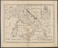
- Creator:
- Wells, Edward, 1667-1727
- Published / Created:
- 172-?]
- Call Number:
- 400 172XB
- Container / Volume:
- BRBL_00232
- Image Count:
- 1
- Resource Type:
- Maps, Atlases & Globes
- Description:
- English, with Latin place names.
- Found in:
- Beinecke Rare Book and Manuscript Library > A new map of antient Italy : together with the adjoyning islands of Sicily, Sardinia, and Corsica, shewing their principal divisions, cities, towns, rivers, mountains &c. / Sutton Nicholls sculp.