Carta-base della futura Europa politica, cenno esplicativo.
Description:
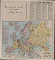
Accompanied by: Carta-base della futura Europa politica, cenno esplicativo. 15 p. ; 24 cm., Relief shown by shading and spot heights., and Shows existing and projected borders in Europe and adjacent parts of Middle East.
Inset map: "Kultur's Empire," spring of 1918., Relief shown by spot heights., and Shows peace conference boundaries, evacuated enemy territory, and neutral zone.
Publisher:
C.S. Hammond,
Subject (Geographic):
Europe--Boundaries--Maps
Subject (Topic):
Territory, National--Europe--Maps and World War, 1914-1918--Territorial questions--Maps
Includes text in German and English protesting the proposed boundaries of Czechoslovakia as infringing upon ethnically German, Slovakian and Polish territories.
Publisher:
L.V. Enders'schen K.-A.,
Subject (Geographic):
Czech Republic--Boundaries--Germany--Maps and Germany--Boundaries--Czech Republic--Maps
Subject (Topic):
Germans--Czech Republic--Bohemia--Maps, Germans--Czech Republic--Sudetenland--Maps, and World War, 1914-1918--Territorial questions--Maps