Search
You Searched For
Search Results
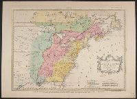
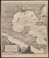
- Creator:
- Palairet, Jean, 1697-1774
- Published / Created:
- 1756
- Call Number:
- 755 1756D
- Container / Volume:
- BRBL_00428
- Image Count:
- 1
- Resource Type:
- Maps, Atlases & Globes
- Description:
- , map 18, issue 1756 (c).
- Subject (Geographic):
- North America--Maps--Early works to
- Subject (Topic):
- British--North America--Maps--Early
- Found in:
- Beinecke Rare Book and Manuscript Library > Carte des possessions angloises & françoises du continent de l'Amérique septentrionale / par I. Palairet, Londres ; Thos. Kitchin, sculpt.
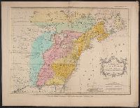
- Creator:
- Palairet, Jean, 1697-1774
- Published / Created:
- 1755
- Call Number:
- 755 1755E
- Container / Volume:
- BRBL_00427
- Image Count:
- 1
- Resource Type:
- Maps, Atlases & Globes
- Subject (Geographic):
- France--Colonies--America--Maps--Early
- Found in:
- Beinecke Rare Book and Manuscript Library > Carte des possessions angloises & françoises du continent de l'Amérique septentrionale / Thos. Kitchin, sculpt.
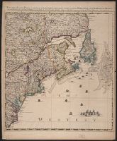
- Creator:
- Popple, Henry, -1743
- Published / Created:
- [ca. 1741]
- Call Number:
- 755 1734A
- Container / Volume:
- BRBL_00426
- Image Count:
- 1
- Resource Type:
- Maps, Atlases & Globes
- Subject (Geographic):
- North America--Maps--Early works to
- Found in:
- Beinecke Rare Book and Manuscript Library > A map of the British Empire in America, with the French, Spanish and Hollandish settlements adjacent thereto / by Henry Popple.
- Creator:
- Popple, Henry, -1743
- Published / Created:
- [ca. 1741]
- Call Number:
- 755 1734B
- Container / Volume:
- BRBL_00426
- Image Count:
- 1
- Resource Type:
- Maps, Atlases & Globes
- Subject (Geographic):
- North America--Maps--Early works to
- Found in:
- Beinecke Rare Book and Manuscript Library > A map of the British Empire in America, with the French, Spanish and Hollandish settlements adjacent thereto / by Henry Popple.
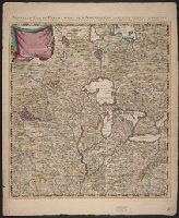
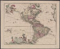
- Creator:
- Wit, Frederik de
- Published / Created:
- [1680]
- Call Number:
- 70 1757A
- Container / Volume:
- BRBL_00686
- Image Count:
- 1
- Resource Type:
- Maps, Atlases & Globes
- Description:
- Includes note, "America" in ornamental
- Subject (Geographic):
- America--Maps--Early works to 1800
- Found in:
- Beinecke Rare Book and Manuscript Library > Novissima et accuratissima septentrionalis ac meridionalis Americae : descriptio, multis locis recentibus aucta et correcté divisa in omnes partes hodiernas / per Fredericum de Witt.
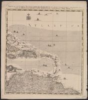
- Creator:
- Popple, Henry, -1743
- Published / Created:
- [ca. 1741]
- Call Number:
- 85 1760A
- Container / Volume:
- BRBL_00693
- Image Count:
- 1
- Resource Type:
- Maps, Atlases & Globes
- Description:
- . Popple undertook this map with the
- Subject (Geographic):
- North America--Maps--Early works to
- Found in:
- Beinecke Rare Book and Manuscript Library > A map of the British Empire in America, with the French, Spanish and Hollandish settlements adjacent thereto / by Henry Popple.
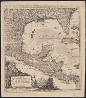
- Creator:
- Popple, Henry, -1743
- Published / Created:
- [ca. 1741]
- Call Number:
- 89 1733
- Container / Volume:
- BRBL_00697
- Image Count:
- 1
- Resource Type:
- Maps, Atlases & Globes
- Description:
- . Popple undertook this map with the
- Subject (Geographic):
- North America--Maps--Early works to
- Found in:
- Beinecke Rare Book and Manuscript Library > A map of the British Empire in America, with the French, Spanish and Hollandish settlements adjacent thereto / by Henry Popple.
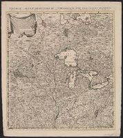
- Creator:
- Popple, Henry, -1743
- Published / Created:
- [ca. 1741]
- Call Number:
- 71 1741
- Container / Volume:
- BRBL_00687
- Image Count:
- 1
- Resource Type:
- Maps, Atlases & Globes
- Description:
- . Popple undertook this map with the
- Subject (Geographic):
- North America--Maps--Early works to
- Found in:
- Beinecke Rare Book and Manuscript Library > A map of the British Empire in America, with the French, Spanish and Hollandish settlements adjacent thereto / by Henry Popple.
- Creator:
- Popple, Henry, -1743
- Published / Created:
- [ca. 1741]
- Call Number:
- 85 1734
- Container / Volume:
- BRBL_00636
- Image Count:
- 1
- Resource Type:
- Maps, Atlases & Globes
- Description:
- . Popple undertook this map with the
- Subject (Geographic):
- North America--Maps--Early works to
- Found in:
- Beinecke Rare Book and Manuscript Library > A map of the British Empire in America, with the French, Spanish and Hollandish settlements adjacent thereto / by Henry Popple.