Skip to search
Skip to main content
Skip to first result
Search
You Searched For
Repository
Beinecke Rare Book and Manuscript Library
Format
cartographic
Genre
Maps in books
Resource Type
Prints & Photographs
New Search
Search Results
Creator:
Published / Created:
1775 Feb 20
Call Number:
1973 Folio 80
Collection Title:
The West-India atlas: or, A compendious description of the West-Indies: illustrated with forty
Image Count:
1
Resource Type:
Prints & Photographs
Description:
Includes scale.
Publisher:
Robt Sayer
Subject (Geographic):
Caribbean Sea --Maps. and West Indies --Maps
Subject (Topic):
Nautical charts --Caribbean Sea --To 1800
Collection Created:
London, Printed for R. Sayer and J. Bennett, 1780
Found in:
Beinecke Rare Book and Manuscript Library > Curacao from the Dutch originals of Gerard Van Keulen
Creator:
Published / Created:
1805
Call Number:
Folio Q115 H84 5
Collection Title:
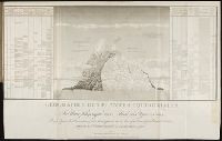
Essai sur la geographie des plantes, accompagne dun tableau physique des regions equinoxiales
Image Count:
1
Resource Type:
Prints & Photographs
Description:
At foot: Esquisse et redige par M. de Humboldt, dessine par Schonberger et turpin a Paris en 1805, grave par Bouquetm la Lettre par Beauble, imprime par Langlois.
Subject (Geographic):
South America
Subject (Topic):
Botany --South America., Discoveries in geography., and Plants
Collection Created:
Paris : F. Schoell, 1807
Found in:
Beinecke Rare Book and Manuscript Library > Geographie des plantes equinoxiales. / Tableau physiquw des Andes et Pays voisins/ Dresse d'apres des Observations & des Mesures preises Sir les Lieux depuis le 10 degre de latitude boreale jusqu'au 10 de latitude australe en 1799, 1800, 1801, 1802 at 180
Creator:
Published / Created:
1775 Feb 20
Call Number:
1973 Folio 80
Collection Title:
The West-India atlas: or, A compendious description of the West-Indies: illustrated with forty
Image Count:
1
Resource Type:
Prints & Photographs
Description:
Includes scale.
Publisher:
Robt Sayer
Subject (Geographic):
Caribbean Sea --Maps. and West Indies --Maps
Subject (Topic):
Nautical charts --Caribbean Sea --To 1800
Collection Created:
London, Printed for R. Sayer and J. Bennett, 1780
Found in:
Beinecke Rare Book and Manuscript Library > The Virgin Islands from English and Danish surveys
Branch:v1.61.6 ,Deployed:2024-06-12T09:55:37-04:00