Carte des possessions angloises et françoises du continent de l'Amérique septentrionale
Description:
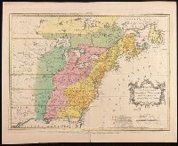
"On trouvera dans le troisiéme volume de la Nouvelle introduction à la géographie moderne ..." at bottom., Appeared in Jean Palairet's Atlas methodique., Prime meridians: Ferro and London., Relief shown pictorially., and Variant with "Explication" in French and English and with additional boundary lines with titles in French drawn horizontally across the map.
Publisher:
[Jean Palairet],
Subject (Geographic):
France--Colonies--America--Maps--Early works to 1800., Great Britain--Colonies--America--Maps--Early works to 1800., North America--Maps--Early works to 1800., and United States--History--French and Indian War, 1755-1763--Maps
"On trouvera dans le troisiéme volume de la Nouvelle introduction à la géographie moderne ..." at bottom., Appeared in Jean Palairet's Atlas methodique., Mounted on heavy paper. On sheet 44 x 60 cm. Stamp on verso: Yale Horace Brown 1900S., Prime meridians: Ferro and London. Coordinates converted by cataloger to express longitude as measured from the Greenwich meridian., Relief shown pictorially., and Variant with "Explication" in French only.
Subject (Geographic):
France--Colonies--America--Maps--Early works to 1800., Great Britain--Colonies--America--Maps--Early works to 1800., North America--Maps--Early works to 1800., and United States--History--French and Indian War, 1755-1763--Maps--Early works to 1800.
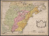
"Avec Privilege du Roi.", Insets: Map of territory west of Lake Superior; map of territory west of Florida; view of "Sault du Niagara, de 135 pieds de haut"., Relief shown pictorially., and Second state: contains two keys to colors "Couleur selon les pretentions des Anglois" and "Selon les pretentions de la France."
Publisher:
[Georges-Louis Le Rouge] Rue des Augustins,
Subject (Geographic):
Atlantic States--Maps--Early works to 1800., France--Colonies--America--Maps--Early works to 1800., Great Britain--Colonies--America--Maps--Early works to 1800., Maritime Provinces--Maps--Early works to 1800., and United States--History--French and Indian War, 1754-1763--Maps--Early works to 1800.