Skip to search
Skip to main content
Skip to first result
Search
You Searched For
Format
cartographic
Genre
Maps.
Search Results
Creator:
Published / Created:
1830
Call Number:
764 An23 1830
Image Count:
1
Resource Type:
Maps, Atlases & Globes
Description:
Covers also town of North Andover and a portion of the City of Lawrence, Massachusetts.
Publisher:
Pendleton's Lithogy.,
Subject (Geographic):
Andover (Mass. : Town)--Buildings, structures, etc.--Maps., Andover (Mass. : Town)--Maps., Lawrence (Mass.)--Maps., and North Andover (Mass. : Town)--Maps.
Subject (Name):
Pendleton's Lithography.
Subject (Topic):
Landowners--Massachusetts--Andover (Town)--Maps., Landowners--Massachusetts--Lawrence--Maps., Landowners--Massachusetts--North Andover (Town)--Maps., Real property--Massachusetts--Andover (Town)--Maps., Real property--Massachusetts--Lawrence--Maps., and Real property--Massachusetts--North Andover (Town)--Maps.
Found in:
Beinecke Rare Book and Manuscript Library > A plan of Andover taken for the town / by Moses Dorman, Jr.
Creator:
Published / Created:
[1744]
Call Number:
BrSides Folio 2017 33
Image Count:
1
Resource Type:
Maps, Atlases & Globes
Description:
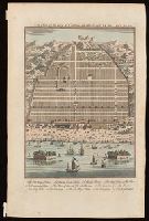
Bird's-eye view of Canton, now Guangzou, China; relief shown pictorially.
Publisher:
[T. Woodward],
Subject (Geographic):
Guangzhou (China)--Maps--Early works to 1800.
Subject (Name):
Harris, John, 1667?-1719. Navigantium atque itinerantium bibliotheca.
Found in:
Beinecke Rare Book and Manuscript Library > A plan of the city of Canton on the river Ta ho [cartographic material].
Creator:
Published / Created:
[1625]
Call Number:
BrSides Box 2019 15
Image Count:
2
Resource Type:
Maps, Atlases & Globes
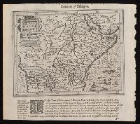
Description:
Relief shown pictorially.
Publisher:
[Printed by William Stansby for Henrie Fetherstone],
Subject (Geographic):
Africa, Central--Maps--Early works to 1800.
Subject (Name):
Featherstone, Henry, -1647, bookseller., Purchas, Samuel, 1577?-1626. Purchas his Pilgrimage. 1625., and Stansby, William, active 1597-1638, printer.
Found in:
Beinecke Rare Book and Manuscript Library > Abissinorum Regnu[m].
Published / Created:
[1842?]
Call Number:
361 1845B
Image Count:
1
Resource Type:
Maps, Atlases & Globes
Alternative Title:
Die nicht zum deutschen bunde gehörigen östlichen provinzen des Preussischen Staats. and Platt's grosser Atlas der Erde.
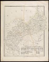
Description:
In upper right: Platt's Grosser atlass [sic] der Erde, no. 21.
Publisher:
Geogr. lith. Institut v. Albr. Platt ,
Subject (Geographic):
Poznań (Poland)--Administrative and political divisions--Maps. and Prussia, East (Poland and Russia)--Administrative and political divisions--Maps.
Subject (Name):
Platt, Albert, 1794-1862.
Found in:
Beinecke Rare Book and Manuscript Library > Abtheilung [sic] II, die nicht zum deutschen bunde gehörigen östlichen provinzen des Preussischen Staats.
Creator:
Published / Created:
1st April 1812.
Call Number:
61 1812B
Image Count:
2
Resource Type:
Maps, Atlases & Globes
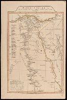
Description:
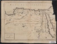
"9"--Manuscript note in upper right corner of sheet. Accompanied by: Title page: A complete body of ancient geography by Mons. D'Anville ... London : James Whittle and Richard Holmes Laurie, 1818 (1 sheet).
Publisher:
Laurie & Whittle,
Subject (Geographic):
Egypt--Administrative and political divisions--Maps. and Egypt--Maps.
Subject (Name):
Laurie & Whittle
Subject (Topic):
Historical geography.
Found in:
Beinecke Rare Book and Manuscript Library > Aegyptus Antiqua Mandato Serenissimi Delphini publici juris facta / Auctor d'Anville Regiae Humaniorum Litterarum Academiae et scientiarum Petropolitanae socius, et Aurelianorum Celsiss. Duci a Secretis. MDCCLXV.
Published / Created:
[1750?]
Call Number:
615 32
Container / Volume:
BRBL_00332
Image Count:
2
Resource Type:
Maps, Atlases & Globes
Description:
"Octavo, Vol. 2, p. 371" in lower left corner.
Publisher:
[publisher not identified],
Subject (Geographic):
Egypt--Historical geography--Early works to 1800--Maps., Egypt--Maps--Early works to 1800., Libya--Historical geography--Early works to 1800--Maps., and Libya--Maps--Early works to 1800.
Subject (Topic):
Manuscript waste (Binding)
Found in:
Beinecke Rare Book and Manuscript Library > Aegyptus et Cyrenaica.
Creator:
Published / Created:
[1748]
Call Number:
BrSides Folio 2017 11
Image Count:
1
Resource Type:
Maps, Atlases & Globes
Alternative Title:
Gentleman's magazine (London, England)
Description:
Also covers the Arabian Peninsula, and portions of Iraq and Iran.
Publisher:
[Gentleman's Magazine],
Subject (Geographic):
Africa--Maps--Early works to 1800.
Found in:
Beinecke Rare Book and Manuscript Library > Africa [cartographic material] / drawn from the best maps by T. Jefferys, Geographer to his Royal Highness the Prince of Wales.
Creator:
Published / Created:
after 1741]
Call Number:
60 1735
Container / Volume:
BRBL_00323
Image Count:
1
Resource Type:
Maps, Atlases & Globes
Description:
"Cum gratia et privil. S.R.I. Vicari atg., in partibg. Rheni, Suevice, et juris Franconici."
Publisher:
M. Seutter,
Subject (Geographic):
Africa--Maps--Early works to 1800.
Found in:
Beinecke Rare Book and Manuscript Library > Africa iuxta navigationes et observationaes recentissimas aucta, correcta et in sua regna et status divisa / in lucem edita a Matth. Seuttero, s. Caes. maj. geographo aug.
Creator:
Published / Created:
[1872?]
Call Number:
BrSides Folio 2019 97
Image Count:
1
Resource Type:
Maps, Atlases & Globes
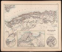
Alternative Title:
Algérie, Algiers and environs on an enlarged scale., Constantine and environs., and Oran and environs.
Description:
Appears in: Royal illustrated atlas of modern geography. London ; Edinburgh : A. Fullarton and Co., [1872?]. (pl. XLVI).
Publisher:
A. Fullarton and Co.,
Subject (Geographic):
Algeria--Maps.
Subject (Name):
A. Fullarton & Co., A. Fullarton & Co. Royal illustrated atlas of modern geography., and Edward Stanford Ltd.
Found in:
Beinecke Rare Book and Manuscript Library > Algeria [cartographic material] = l'Algérie / drawn by J. Hugh Johnson ; engraved at Stanford's Geographical Establishment.
Creator:
Published / Created:
1756
Call Number:
755 1756Ea
Image Count:
1
Resource Type:
Maps, Atlases & Globes
Description:
Appears in various eds. of Atlas geographicus maior.
Publisher:
[Homann Erben],
Subject (Geographic):
North America--Maps--Early works to 1800. and United States--History--French and Indian War, 1755-1763--Maps--Early works to 1800.
Subject (Name):
Anville, Jean Baptiste Bourguignon d', 1697-1782. and Homann Erben (Firm). Atlas geographicus maior.
Found in:
Beinecke Rare Book and Manuscript Library > America Septentrionalis a Domino d'Anville in Galliis edita nunc in Anglia : coloniis in interiorem Virginiam deductis nec non Fluvii Ohio cursu aucta notisque geographicis et historicis illustrata / sumptibus Homannianorum Heredum.