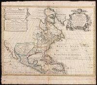
Appears in various eds. of Atlas geographicus maior., Includes German text relating to English and French territorial claims., Place names and descriptive notes in English., Prime meridian: Ferro and London., and Relief shown pictorially.
Publisher:
[s.n.],
Subject (Geographic):
North America--Maps--Early works to 1800. and United States--History--French and Indian War, 1755-1763--Maps--Early works to 1800.
Subject (Name):
Anville, Jean Baptiste Bourguignon d', 1697-1782. and Homann Erben (Firm). Atlas geographicus maior.
Includes five bar scales., Relief shown pictorially., and Watermark. Manuscript number in upper right corner: jj5. Reinforced at bottom with paper. From the Karpinski Collection.
Publisher:
Venalis prostat Augustae Vindelic apud Jeremiam Wolff,
Subject (Geographic):
North America--Maps.
Subject (Name):
Karpinski, Louis Charles,--1878-1956--Ownership. and Wolf, Jeremias, 1663?-1724, pulbisher.
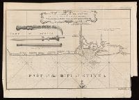
Coordinates not present on map and are approximated., From A new general collection of voyages and travels (London, 1745-47)., Includes illustrations of "weapons used by the Hakbous blacks.", Lower left: "No. 87.", Lower right: "Plate X, Vol. III, p. 105.", and Stamps: Glasgow Public Libraries.
Publisher:
[publisher not identified],
Subject (Geographic):
Cross River State (Nigeria)--Maps--Early works to 1800.
Subject (Name):
Child, G., engraver. and Glasgow (Scotland). Public Libraries Stamp.
Subject (Topic):
Coasts--Nigeria--Calabar Province--Maps--Early works to 1800.
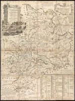
Concentric rings at one mile intervals from Huntingdon., Dedicated to the Robert Montagu, Duke of Manchester., Imperfect: edges trimmed, with loss of imprint information. Dissected and mounted on linen. In cover with label "17 Huntingdonshire.", Notes about the county; includes "Index Villaris.", Prime meridian: London., Relief shown by hachures., and Shows boundaries, roads, woods, parks and settlements.
Publisher:
[Emanuel Bowen?],
Subject (Geographic):
Huntingdonshire (England)--Early works to 1800--Maps.
Subject (Name):
Bowles, John, 1701-1779, publisher. and Hinton, John, -1781, bookseller.
"European Magazine" in upper right., Coordinates not present on map and are approximated., Imperfect: left portion of map and upper right portion of map wanting, with some loss of text., Relief shown pictorially., and Watermark.
Publisher:
Published April 1, 1782, by I. Fielding, Pater noster Row, J. Sewell, Cornhill, and J. Debrett, Piccadilly,
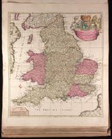
"Cum privilegio.", Appeared in Peter Schenk's Atlas contractus, ca. 1700., Backed with paper. Ms. no. "48" in lower-right corner. Sheet measures 62.8 x 53.7 cm. No. 45 of 87 maps bound together., Bar scales given in "milliaria Anglica," "milliaria Germanica," and "milliaria Gallica"., Prime meridian: Ferro., Relief shown pictorially., and Watermark.
Publisher:
Peter Schenk,
Subject (Geographic):
England--Maps--Early works to 1800.
Subject (Name):
Schenk, Peter, 1660-1718 or 1719. Atlas contractus.
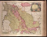
"Cum privil. H. et W-frisiae"., Appeared in Valk and Schenk's Atlantis sylloge compendiosa, ca. 1702., Backed with paper. Ms. no. "36" in upper left-hand corner. Sheet measures 53.6 x 62.8 cm. No. 35 of 87 maps bound together., Bar scales given in "milliaria Germanica," "milliaria Gallica," and "milliaria Italica"., Prime meridian: Ferro., Relief shown pictorially., and Watermark.
Publisher:
Gerard Valk,
Subject (Geographic):
Limburg (Belgium : Province)--Maps--Early works to 1800. and North Rhine-Westphalia (Germany)--Maps--Early works to 1800.
Subject (Name):
Schenk, Peter, 1660-1718 or 1719. Atlantis sylloge compendiosa. and Valck, G. (Gerard), 1651 or 1652-1726. Atlantis sylloge compendiosa.
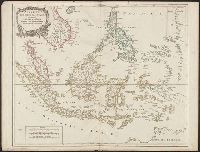
Covers present-day Indonesia, the Philippines, Malayan peninsula, Indo-Chinese peninsula, and north-west coast of Australia., From: Atlas universel / par m. Robert geographe et Robert de Vaugondy son fils. Paris, 1757-[1786]., Includes inset map., and Inset: Isl
Publisher:
[publisher not identified],
Subject (Geographic):
Asia--East Indies, Australia--Maps--Early works to 1800., East Indies--Maps--Early works to 1800., Mariana Islands--Maps--Early works to 1800., and Southeast Asia--Maps--Early works to 1800.
Subject (Name):
Haye, G. de la, engraver. and Robert de Vaugondy, Gilles, 1688-1766. Atlas universel.
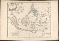
"Archipel des Indes" stamped twice on verso., Appeared in: Gilles and Didier Robert de Vaugondy, "Atlas Universel", 1753-1757 [or later]., Covers present-day Indonesia, the Philippines, Malayan peninsula, Indo-Chinese peninsula, and north-west coast of Australia., Includes inset map., Inset: Isles Marianes des Larons., Relief shown pictorially., and Watermarks.
Publisher:
[publisher not identified],
Subject (Geographic):
Southeast Asia--Maps--Early works to 1800.
Subject (Name):
Haye, G. de la, engraver., Robert de Vaugondy, Didier, 1723-1786. Atlas Universel., and Robert de Vaugondy, Gilles, 1688-1766. Atlas universel.