Skip to search
Skip to main content
Skip to first result
Search
You Searched For
Access
Public
Format
cartographic
Genre
Marginalia
Subject (Topic)
Atlases, German --Early works to 1800
New Search
Search Results
Creator:
Published / Created:
1741
Call Number:
1973 Folio 30
Collection Title:
[Atlas factice of 32 maps and 1 distance table, produced by the Homann Erben firm]
Image Count:
2
Alternative Title:
Carte de France dressee par Guillaume de L’Isle et accommodee par les Heritiers d’Homann
Publisher:
[Homann Erben]
Subject (Geographic):
France --Maps --Early works to 1800
Subject (Topic):
Atlases, German --Early works to 1800
Collection Created:
[Nuremberg : s.n.,
Found in:
Beinecke Rare Book and Manuscript Library > Regni Galliae seu Franciae et Navarrae [cartographic material] : tabula geographica in usum elementorum geographiae schazianorum accom[m]odata / per Homannianos Heredes
Creator:
Published / Created:
1728?
Call Number:
1973 Folio 30
Collection Title:
[Atlas factice of 32 maps and 1 distance table, produced by the Homann Erben firm]
Image Count:
3
Alternative Title:
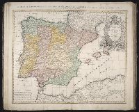
Regnorum Hispaniae et Portugalliae tabula generalis de l’Isliana and Reyno de Espanna dividido en dos grandes estados de Aragon y de Castilla, subdividido en muchas provincias donde se halla tambien el Reyno de Portugal
Publisher:
[Homann Erben]
Subject (Geographic):
Portugal --Maps --Early works to 1800 and Spain --Maps --Early works to 1800
Subject (Topic):
Atlases, German --Early works to 1800
Collection Created:
[Nuremberg : s.n.,
Found in:
Beinecke Rare Book and Manuscript Library > Regnorvm Hispaniae et Portvgalliae tabula generalis de l'Isliana / [cartographic material] / aucta et ad usum scholarum novissime accom[m]odata a Ioh. Bapt. Homanno, S.C.M. Geogr.
Creator:
Published / Created:
between 1701 and 1709?
Call Number:
1973 Folio 30
Collection Title:
[Atlas factice of 32 maps and 1 distance table, produced by the Homann Erben firm]
Image Count:
2
Publisher:
[Johann Baptist Homann]
Subject (Geographic):
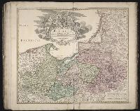
Prussia (Germany) --Maps --Early works to 1800 and Prussia, east (Poland and Russia) --Maps --Early works to 1800
Subject (Topic):
Atlases, German --Early works to 1800
Collection Created:
[Nuremberg : s.n., 1701-1760]
Found in:
Beinecke Rare Book and Manuscript Library > Regnum Borussiae [cartographic material] : gloriosis auspicys serenissimi et potentissimi Prin. Friderici III. Primi Borussiae Regis, March. et Elect. Bran. inauguratum die 18. Ian. a. 1701 / geographice cum vicinis regionibus adumbratum a Ioh. Baptista H
Creator:
Published / Created:
a. 1748
Call Number:
1973 Folio 30
Collection Title:
[Atlas factice of 32 maps and 1 distance table, produced by the Homann Erben firm]
Image Count:
2
Alternative Title:
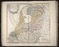
Septem provinciae seu Belgium Foederatum quod generaliter Hollandia
Publisher:
Edentibus Homannianis Heredibus
Subject (Geographic):
Netherlands --Maps --Early works to 1800
Subject (Topic):
Atlases, German --Early works to 1800
Collection Created:
[Nuremberg : s.n., 1701-1760]
Found in:
Beinecke Rare Book and Manuscript Library > Septem provinciae seu Belgivm Foederatvm quod generaliter Hollandia [cartographic material] : audit speciali mappa delineatum adhibitis auxilium observationibus astronomieis nec non mensurationibus Snellii, Muschenbrokii, etc. / auctore Tobia Mayero ...
Branch:v1.61.6 ,Deployed:2024-06-12T09:55:31-04:00