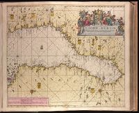
"18" in lower right corner., "Met Previlegie voor 15 Iaar"., Appeared in Gerard van Keulen's Nieuwe groote ligtende Zee-Fakkel ... 1734; cf. Koeman, C. Atlantes Neerlandici, IV, Keu 45, map 30., Backed with paper. Ms. no. "14" in upper right-hand corner. Sheet measures 53.6 x 62.5 cm. No. 14 of 87 maps bound together., Includes four bar scales, Relief shown pictorially; depths shown by soundings., Watermark., and With north oriented towards the right.
Publisher:
By Johannes van Keulen ...,
Subject (Geographic):
Finland--Maps--Early works to 1800. and Sweden--Maps--Early works to 1800.
Subject (Name):
Keulen, Gerard van. Nieuwe groote lichtende zee-fakkel. and Vooght, Claes Janszoon, -1696.
Subject (Topic):
Nautical charts--Bothnia, Gulf of--Early works to 1800.