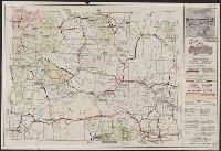
Highway map of the state of Wyoming and Wyoming worth knowing.
Description:
Includes ill. and text., Relief shown by hachures and spot heights., Text, photos, and highway map of United States on verso., and Verso caption: Wyoming worth knowing.
Publisher:
Wyoming State Dept. of Commerce and Industry, in cooperation Wyoming State Highway Dept.,
Subject (Geographic):
Wyoming--Maps
Subject (Name):
Wyoming. Dept. of Commerce and Industry and Wyoming. State Highway Dept
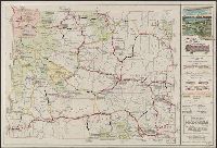
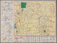
Highway map of the state of Wyoming and Wyoming worth knowing.
Description:
Also shows air routes, national forests, game refuges, national parks and monuments, Indian reservations, military reservations, and historic trails., Includes ill. and text., and Photos, text, distance table, and map of western states (scale [ca. 1:12,500,000]
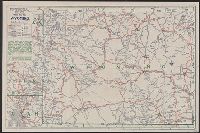
Automobile roads in Wyoming and Official road map, Wyoming
Description:
In lower right: A., Map of "Yellowstone National Park," ill., and advertisements on verso., Relief shown by hachures and spot heights., and Stamped: JUN 13 27.
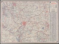
Idaho, Montana, Wyoming and Rand McNally road map, United States.
Description:
"9-464019V-5.", "Rand McNally road map, United States," (scale [ca. 1:10,327,680]), text, ill. and distance table on verso., Indexed., and Relief shown pictorially and by spot heights.
Publisher:
Rand McNally,
Subject (Geographic):
Idaho--Maps, Montana--Maps, and Wyoming--Maps
Subject (Name):
Randall Motor Club
Subject (Topic):
Express highways--United States--Maps, Roads--Idaho--Maps, Roads--Montana--Maps, and Roads--Wyoming--Maps
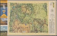
Texaco sectional trip map [of western states]., Touring map of Wyoming, and Wyoming with sectional map of adjoining states
Description:
"Texaco sectional trip map [of western states]" (scale [ca. 1:4,181,760]), text, and ill. on verso., "X.3846.", and Includes index, 2 local route maps, and road maps of "Yellowstone Nat'l Park and Grand Teton Nat'l Park, Wyo." and "Black Hills region, S. Dak."
"2-4617-5.", Includes index to cities and towns, text, and color photographs., Map of western United States, distance table, and color photos on verso., Relief shown by shading and spot heights., and Title taken from folded panel.
"Issued for free distribution only by Wyoming State Highway Commission and Wyoming Tourist Bureau.", In lower right: 5-4617-8., Includes indexes, ill., and text., Map of "Western United States," col. photos, distance table, and text on verso., and Relief shown by shading and spot heights.
Publisher:
Wyoming State Highway Commission? : and Wyoming Tourist Bureau?,
Subject (Geographic):
Wyoming--Maps
Subject (Name):
Wyoming Tourist Bureau, Wyoming. State Highway Commission, and Wyoming. State Highway Dept
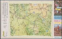
Wyoming, 1976, official highway map and Wyoming, official highway map
Description:
At bottom of panel: Official highway map., Color photos, text, and area map on verso., Includes indexes, distance table, 7 local route maps, text, and ill., Panel title., and Relief shown by shading and spot heights.