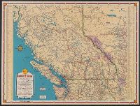
"1939-1", "Above data in effect as of January 1, 1939", Also shows northern Washington, northern Idaho, and northwestern Montana., At head of title: Shell., Directory of radio stations in British Columbia, Alberta, and the western United States on verso., and Inde
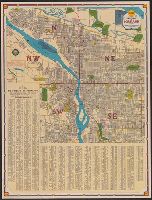
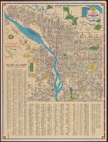
Columbia River Highway, Bridal Veil bridge to The Dalles., Metropolitan Portland and vicinity., and Street guide and metropolitan map of Portland and vicinity
Description:
"10-M-1939-1.", "Traffic rules" text and maps "Metropolitan Portland and vicinity" with index, scale [ca. 1:202,000] and "Columbia River Highway: Bridal Veil bridge to The Dalles" (U.S. highway 30) scale [ca. 1:180,000] on verso., At head of title: Shell., and Includes index and inset of "Portland, system of street directions."
Publisher:
The H.M. Gousha Co.,
Subject (Geographic):
Columbia River Highway (Or.)--Maps and Portland (Or.)--Maps
Subject (Name):
Shell Oil Company
Subject (Topic):
Roads--Oregon--Portland Metropolitan Area--Maps and Streets--Oregon--Portland--Maps
Street guide and metropolitan map of Portland and vicinity
Description:
"L-1 1938-1.", Indexed., Relief shown by hachures., and Text, ill. and "Metropolitan Portland and vicinity" and "Columbia River Highway, Bridal Veil Bridge to the Dalles" maps on verso.