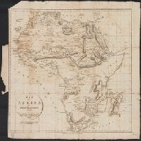
Boundaries hand colored., From Johnston's Royal atlas of modern geography?, Prime meridian: Greenwich., Relief shown by hachures., and Upper right: 36.
Subject (Geographic):
Africa--Maps
Subject (Name):
Johnston, Alexander Keith, 1804-1871. Royal atlas of modern geography and W. & A.K. Johnston Limited, publisher
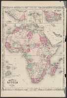
Inset map: St. Helena. Scale [ca. 1:280,000]., Inset view: Cape Town and Table Mount., Prime meridians: Greenwich and Washington., and Relief shown by hachures.
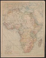
Africa and Johnson's new illustrated family atlas.
Description:
"Entered according to Act of Congress in the year 1864 by A.J. Johnson in the Clerks Office of the District Court of the United States for the Southern District of New York." and Appears in: Johnson's New illustrated family atlas ... -- New York : Johnson and
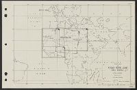
Central Committee on the United Study of Foreign Missions
Published / Created:
c1905.
Call Number:
60 1905
Container / Volume:
BRBL_00328
Image Count:
1
Resource Type:
Maps, Atlases & Globes
Alternative Title:
Christus Liberator.
Description:
"Note: this map may be ordered from any of the Woman's Boards of Foreign Missions in the United States and Canada." and Relief shown by hachures and spot heights.
Publisher:
Central Committee on the United Study of Missions,
Mr. H.M. Stanley's explorations in the Dark Continent :
Description:
Outside neatline and map layout, top map sheet: nine portraits titled "The officers with Mr. Stanley in the Advance Column.", Outside neatline, textual legend "Itinerary of Stanley's Journeys.", Prime meridian Greenwich., and Relief shown pictorially.
Copyright, 1909, by the J.N. Matthews Co., Buffalo, N.Y., Relief shown by hachures and spot heights., and Suppl. to The National Geographic Magazine, March 1909.
Publisher:
National Geographic Society,
Subject (Geographic):
Africa--Maps
Subject (Name):
Grosvenor, Gilbert Hovey, 1875-1966, J.N. Matthews Co, and National Geographic Society (U.S.)