
You Searched For
1 - 6 of 6
Search Results

- Creator:
- Kenyon Company (Des Moines, Iowa)
- Published / Created:
- 1918
- Call Number:
- 11hc 1918O
- Container / Volume:
- BRBL_00010F
- Image Count:
- 2
- Resource Type:
- Maps, Atlases & Globes
- Alternative Title:
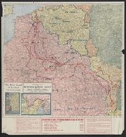
- Battle ground of freedom, Kenyon's War pocket map of the Western battle front of Europe, and Western Europe
- Description:
- Index of towns on verso., Insets: Map of the Eastern battle front; Map of the Italian battle front., and Shows battle lines from 1914 through October 21st, 1918, with "Explanation of lines, letters and numbers in red on this map" printed at bottom of sheet.
- Publisher:
- Kenyon Company,
- Subject (Geographic):
- Europe--Maps and France--Maps
- Subject (Topic):
- World War, 1914-1918--Europe--Maps and World War, 1914-1918--France--Maps
- Found in:
- Beinecke Rare Book and Manuscript Library > Kenyon's Map of the western battle front [cartographic material] : "The battle ground of freedom" where our boys are fighting.
- Creator:
- Geographical Publishing Co
- Published / Created:
- 1917
- Call Number:
- 11hc 1917F
- Container / Volume:
- BRBL_00010D
- Image Count:
- 2
- Resource Type:
- Maps, Atlases & Globes
- Alternative Title:
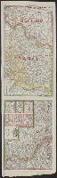
- Western battle front no. 1, Nieuport to Reims and Western battle front, Reims, France to Basel, Switzerland
- Description:
- Includes 3 insets: Russo-German war front -- [Franco-German border] -- Pozieres and environs., Includes advertisement for First and old Detroit national bank., Includes ill. of military figures, places, soldiers, etc. with captions., and Shows boundaries, roads,
- Publisher:
- Geographical Publishing Co.,
- Subject (Geographic):
- Europe--Maps, France--Maps, Germany--Maps, Poland--Maps, and Russia--Maps
- Subject (Topic):
- World War, 1914-1918--Europe--Maps, World War, 1914-1918--France--Maps, World War, 1914-1918--Germany--Maps, World War, 1914-1918--Poland--Maps, and World War, 1914-1918--Russia--Maps
- Found in:
- Beinecke Rare Book and Manuscript Library > Map of the Franco-German war front : from Hirson, France to Basel, Switzerland, and the Russo-German war front from Riga, Russia, to Lemberg, Austria / Published for the Volume Library.
- Creator:
- Bumstead, Albert H. (Albert Hoit), 1875-1940
National Geographic Society (U.S.). Cartographic Division - Published / Created:
- 1918
- Call Number:
- 30 1918B
- Container / Volume:
- BRBL_00032A
- Image Count:
- 1
- Resource Type:
- Maps, Atlases & Globes
- Alternative Title:
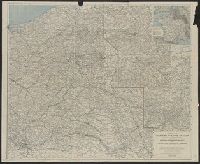
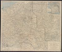
- Index to the map of the Western Theatre of War.
- Description:
- Detached from: National Geographic, May 1918., Indexed by: Index to the map of the Western Theatre of War., and Inset: "Showing relation of the Western Theatre of War to the surrounding region and the connection of the two sections of the main map."
- Publisher:
- The Society,
- Subject (Geographic):
- Alsace (France)--Maps, Europe--Maps, and Lorraine (France)--Maps
- Subject (Topic):
- World War, 1914-1918--Belgium--Maps, World War, 1914-1918--France--Maps, and World War, 1914-1918--Maps
- Found in:
- Beinecke Rare Book and Manuscript Library > Map of the Western Theatre of War / Prepared in the Map Dept. of the National Geographic Society for the National Geographic Magazine ; A. H. Bumstead, cartographer.
- Creator:
- Bumstead, Albert H. (Albert Hoit), 1875-1940
National Geographic Society (U.S.). Cartographic Division - Published / Created:
- 1918
- Call Number:
- 11hc 1918C
- Container / Volume:
- BRBL_00010E
- Image Count:
- 1
- Resource Type:
- Maps, Atlases & Globes
- Alternative Title:
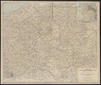
- Index to the map of the Western Theatre of War.
- Description:
- Detached from: National Geographic, May 1918., Indexed by: Index to the map of the Western Theatre of War., and Inset: "Showing relation of the Western Theatre of War to the surrounding region and the connection of the two sections of the main map."
- Publisher:
- The Society,
- Subject (Geographic):
- Alsace (France)--Maps, Europe--Maps, and Lorraine (France)--Maps
- Subject (Topic):
- World War, 1914-1918--Belgium--Maps, World War, 1914-1918--France--Maps, and World War, 1914-1918--Maps
- Found in:
- Beinecke Rare Book and Manuscript Library > Map of the Western Theatre of War / Prepared in the Map Dept. of the National Geographic Society for the National Geographic Magazine ; A. H. Bumstead, cartographer.