Skip to search
Skip to main content
Skip to first result
Search
You Searched For
Format
cartographic
Language
English
Subject (Geographic)
Europe--Maps
New Search
Search Results
Creator:
Published / Created:
c1917.
Call Number:
30 1917B
Container / Volume:
BRBL_00032A
Image Count:
1
Resource Type:
Maps, Atlases & Globes
Description:
Caricature map., Copyright: Karel Horký., and Countries are represented by animal ill. to depict international relations.
Publisher:
s.n.],
Subject (Geographic):
Europe--Maps and Europe--Politics and government--Maps
Subject (Topic):
World War, 1914-1918--Maps
Found in:
Beinecke Rare Book and Manuscript Library > 1914--1915--1916--1917--?? / drawn by J. Lenhard.
Creator:
Published / Created:
[ca. 1917]
Call Number:
307hc 1917
Container / Volume:
BRBL_00036A
Image Count:
2
Resource Type:
Maps, Atlases & Globes
Description:
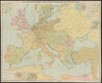
Relief shown by hachures. and Shows: international boundaries, railways, roads, naval stations, fortified towns, sea routes.
Publisher:
G.W. Bacon & Co.,
Subject (Geographic):
Europe--Maps and Europe--Politics and government--Maps
Subject (Topic):
World War, 1914-1918--Belgium--Maps, World War, 1914-1918--France--Maps, and World War, 1914-1918--North Sea--Maps
Found in:
Beinecke Rare Book and Manuscript Library > Bacon's map of the seat of war in the North Sea, Belgium and eastern France.
Branch:v1.61.6 ,Deployed:2024-06-12T09:55:33-04:00