Skip to search
Skip to main content
Skip to first result
Search
You Searched For
Format
cartographic
Language
English
Subject (Geographic)
Europe--Maps
New Search
Search Results
Creator:
Published / Created:
1919
Call Number:
30ed 1919
Container / Volume:
BRBL_00037B
Image Count:
1
Resource Type:
Maps, Atlases & Globes
Publisher:
National Geographic Society,
Subject (Geographic):
Europe--Maps
Subject (Name):
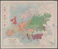
Grosvenor, Edwin A. (Edwin Augustus), 1845-1936, Grosvenor, Gilbert Hovey, 1875-1966, and National Geographic Society (U.S.)
Subject (Topic):
Race--Europe--Maps
Found in:
Beinecke Rare Book and Manuscript Library > Map of the races of Europe and adjoining portions of Asia and Africa / drawn under the direction of Edwin A. Grosvenor and Gilbert Grosvenor in the Map Department of the National Geographic Magazine by Albert H. Bumstead.
Published / Created:
[1915?]
Call Number:
30ag 1915
Container / Volume:
BRBL_00037
Image Count:
2
Resource Type:
Maps, Atlases & Globes
Description:
Verso: Various information.
Subject (Geographic):
Europe--Maps
Found in:
Beinecke Rare Book and Manuscript Library > Map showing the North Atlantic, Mediterranean and Cruising Services of the Hamburg-American Line and European railroad connections.
Creator:
Published / Created:
[1944?]
Call Number:
30 1944A
Container / Volume:
BRBL_00032B
Image Count:
2
Resource Type:
Maps, Atlases & Globes
Publisher:
C.S. Hammond & Co.,
Subject (Geographic):
Europe--Maps
Found in:
Beinecke Rare Book and Manuscript Library > Maps of allied assaults on fortress Europe; Europe, France, Italy, Netherlands and Belgium.
Published / Created:
1915
Call Number:
11hc 1915G
Container / Volume:
BRBL_00010B
Image Count:
1
Resource Type:
Maps, Atlases & Globes
Alternative Title:
Geography of the war
Description:
Relief-Western field, No.1. -- The Forest of Argonne, No.2. -- The Yser Canal System, No.3.
Publisher:
Royal Geographical Society,
Subject (Geographic):
Europe--Maps
Found in:
Beinecke Rare Book and Manuscript Library > Maps to illustrate the paper by Hilaire Belloc on the geography of the war : [in the Geographical Journal, January 1915.]
Published / Created:
1906
Call Number:
11hcf 1919B-8
Container / Volume:
BRBL_00010S
Image Count:
1
Resource Type:
Maps, Atlases & Globes
Publisher:
The McKinley Publishing Co.,
Subject (Geographic):
Europe--Maps
Found in:
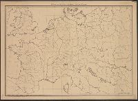
Beinecke Rare Book and Manuscript Library > McKinley's Wall Outline Maps Central Europe.
Published / Created:
1906
Call Number:
11hcf 1919D-51
Container / Volume:
BRBL_00010Y
Image Count:
1
Resource Type:
Maps, Atlases & Globes
Publisher:
The McKinley Publishing Co.,
Subject (Geographic):
Europe--Maps
Found in:
Beinecke Rare Book and Manuscript Library > McKinley's Wall Outline Maps Central Europe.
Published / Created:
1908
Call Number:
11hcf 1919D-52
Image Count:
1
Resource Type:
Maps, Atlases & Globes
Publisher:
The McKinley Publishing Co.,
Subject (Geographic):
Europe--Maps
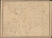
Found in:
Beinecke Rare Book and Manuscript Library > McKinley's Wall Outline Maps France and the Netherlands (Gaul).
Published / Created:
1942?]
Call Number:
11hd 1942R-1
Container / Volume:
BRBL_00010ZE
Image Count:
1
Resource Type:
Maps, Atlases & Globes
Description:
Lower right corner: W.N.R. No. 141. and No. 1, April 1940 -- No. 2, March 1941 -- No. 3, July 1942 -- No. 4, Nov. 1942.
Publisher:
s.n.,
Subject (Geographic):
Africa, North--Maps, Europe--Maps, and Mediterranean Sea--Maps
Found in:
Beinecke Rare Book and Manuscript Library > Mediterranean - Four Phases of War [cartographic material].
Creator:
Published / Created:
c1914.
Call Number:
11hc 1914C
Container / Volume:
BRBL_00010A
Image Count:
1
Resource Type:
Maps, Atlases & Globes
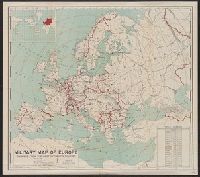
Description:
Includes table showing area and populations of the European powers., Indicates fortified towns, military headquarters, naval stations, railroads; concentric circl, Inset of location map of the world with Europe highlighted in red., and Prime meridian: Greenwich.
Publisher:
General Drafting Co.,
Subject (Geographic):
Europe--Maps
Subject (Topic):
World War, 1914-1918--Europe--Maps and World War, 1914-1918--Maps
Found in:
Beinecke Rare Book and Manuscript Library > Military map of Europe [cartographic material] / compiled from the most authentic sources.
Creator:
Call Number:
30 1939
Container / Volume:
BRBL_00032B
Image Count:
1
Resource Type:
Maps, Atlases & Globes
Publisher:
Bibliographisches Institut AG.,
Subject (Geographic):
Europe--Maps
Found in:
Beinecke Rare Book and Manuscript Library > Mittel- und Nordeuropa.
Branch:v1.61.6 ,Deployed:2024-06-12T09:55:19-04:00